Bosphorus Strait Cruise (Istanbul, Turkey)

Istanbul and the Bosphorus Strait

After a 12 hour, 35 min. long flight from NAIA international Airport (NAIA) Terminal 3, our Turkish Airline (Flight Number TK265) arrived at Istanbul International Airport by 12:30 PM, Sunday, June 16.

Check out “Istanbul International Airport”

The Touristanbul counter at the Istanbul International Airport

Before visiting Turkey, we obtained an e-visa ($30 per pax) at the www.evisa.gov.tr/ website (check your country’s requirements to see if it is necessary to obtain a visa to enter Turkey). If you are eligible for an e-visa, you may obtain it from the Turkish Airlines Sales / Ticket Desks before or on the day of your departure.

Boarding our Touristanbul bus at the airport

Our connecting international flight to Edinburgh Airport, Scotland was still 18 hours and 45 minutes later so we took advantage of our complimentary Touristanbul service to discover Istanbul, the city that never sleeps, during our layover time. According to the time frame best suited to your flight arrival and departure schedule, we selected the 6:30 PM-11 PM tour, one of the eight carefully arranged and planned tours offered by Touristanbul for those with a layover between six and 24 hours.

BUDO Eminonu Pier

With such an abundance of historical sightseeing spots in Istanbul and too little time to squeeze them all into your short holiday, an unforgettable cruise, between two continents (Asia and Europe) along the 32-km. long Bosphorus Strait (not a river) is probably the most overlooked Istanbul tourist attraction. After our Turkish Airlines connecting international flight landed at İstanbul Airport, we proceeded all the way through into international arrivals (past baggage claim), turned right and walk to the end of the hall to TourIstanbul, opposite of the arrival hall of the Turkish Airlines and opposite the passport control at the Transfer Desk.

Boarding the Naral Istanbul

Upon arrival, we all signed up for the free Touristanbul tour at the Hotel Desk in the International Arrivals Terminal of İstanbul Airport (you can also sign up at the Touristanbul Desk Office in the Transfer desk area), using our ticket number issued by Turkish Airlines ticket number starting 235, and got a ticket for the queue.  Istanbul Airport only provides one-hour free wi-fi to fliers that are in the Departure Area.

Paula, Selena, Jandy and Grace on board the Naral Istanbul

The author (right) with Jandy and Grace (photo: Selena Sta. Maria)

Touristanbul is available for Turkish Airlines’ flights, including code share flights. There is no hotel offered. If a guest is unable to make their flight, in cases that are their responsibility, they will ensure that the passenger reaches their destination smoothly via the next flight.

Galata Bridge, the fifth on the same site, was built in 1994. The bridge was named after Galata (the former name for Karaköy) on the northern shore of the Golden Horn. This bascule bridge is 490 m. (1,610 ft.) long with a main span of 80 m. (260 ft.). The deck of the bridge is 42 m. (138 ft.) wide and has two vehicular lanes and one walkway in each direction. Tram tracks running down the middle of it allow the T1 tram to run from Bağcılar, in the western suburbs to Kabataş, a few blocks away from Dolmabahçe Palace.

After signing up and booking our tour, we were picked up by a friendly and well-informed guide named Eray and boarded an airconditioned tourist bus with about 40 other guests. Before joining the tour, we stored our heavy luggage at the luggage office next to the hotel desk ($18 per piece) and just brought our hand-carried bags with us which were stored in the boot of the bus.  The 42.2-km. bus ride, from the airport to the boat landing near the Golden Horn Metro Bridge, took us around 45 mins.

Bosphorus Bridge, the oldest and southernmost of the three suspension bridges spanning the Bosphorus strait, is a gravity-anchored suspension bridge with steel towers and inclined hangers. The aerodynamic deck hangs on steel cables. The bridge is 1,560 m. (5,118 ft.) long, with a deck width of 33.40 m. (110 ft.). The distance between the towers (main span) is 1,074 m. (3,524 ft.) and the total height of the towers is 165 m. (541 ft.). The clearance of the bridge, from sea level, is 64 m. (210 ft.).

The tour covers a lot of territory.  During this unforgettable, two-hour tour experience on board the 24 m. long and 7 m. wide pleasure craft Naral Istanbul, cruising at an average speed of 7.2 knots, having a fabulous view of the legendary Bosphorus Strait and saw some of Istanbul’s most notable and iconic historical sites, structures and monuments. Its rolling hills are covered with a mix of ancient and modern architecture, all of them overlooking the water.

The Maiden’s Tower between Europe and Asia

The Maiden’s Tower (Kiz Kulesi), built in 1725 0n a small islet at the southern entrance of the Bosphorus Strait, between the European and Asian sides, is one of the landmarks and most storied structures of Istanbul.

Maiden’s Tower, a small islet at the southern entrance of the Bosphorus strait, 200 m. (220 yds.) from the coast of Üsküdar, has a café and restaurant with views of the former Roman, Byzantine and Ottoman capital at Sarayburnu. Private boats ply back and forth between the tower and the shore throughout the day. The tower appeared on the reverse of the Turkish 10 lira banknote from 1966 to 1981.

Formerly an observation terrace, a tax collection area for merchants, a hospital and a lighthouse, it now houses a café and restaurant. Recently, it was featured in the 1999 James Bond film The World is Not Enough. From 1966 t0 1981, the tower also appeared on the reverse side of the Turkish 10 lira banknote.

Hatice Sultan Mansion, a historical yalı (waterside mansion) located at Bosporus, in the Ortaköy neighborhood, was named after its original owner Hatice Sultan. It is used today as a water sports club’s building.

Naime Sultan Yalisi was given to Sultan Abdul Hamid II’s favorite daughter Naime upon her marriage to Mehmed Kemaleddin Bey in 1898.

The Bosphorus Strait is home to many beautiful and historical mansions (yalilar).  Many designed by members of the Balyan family (Armenian architects for the Ottoman court for five generations), they are considered an important cultural heritage of Istanbul.   Of the original 600 mansions, about 360 are still standing, with 150 preserved in their original form, each reflecting a particular era and architectural style.

Dolmabahce Palace was home to six Sultans from 1856, when it was first inhabited, up until the abolition of the Caliphate in 1924: The last royal to live here was Caliph Abdülmecid Efendi. A law that went into effect on March 3, 1924, transferred the ownership of the palace to the national heritage of the new Turkish Republic.

Gracing the edges of the Bosphorus Strait, on the European side, is the beautiful and elegant Dolmabahce Palace, the main administrative center of the Ottoman Empire (from 1856 to 1887 and from 1909 to 1922), was built from 1843 and 1856 and was home to the Sultan up to the end of the Ottoman Empire.

Beylerbeyi Palace, an imperial Ottoman summer residence built between 1861 and 1865, is now situated immediately north of the first Bosphorus Bridge. It was the last place where Sultan Abdulhamid II was under house arrest before his death in 1918.

The Beylerbeyi Palace, at the Asian side, is an imperial Ottoman summer residence built between 1861 and 1865.  Designed in the Second Empire style by Sarkis Balyan, it is now a museum.

Ciragan Palace, built by Sultan Abdulaziz to replace the old Çırağan Palace which was at the same location, was designed by the Armenian palace architect Nigoğayos Balyan and constructed by his sons Sarkis and Hagop Balyan between 1863 and 1867. It is now a five-star hotel in the Kempinski Hotels chain.

Four Seasons Istanbul Hotel, formerly the Atik Pasha Palace, is a renovated 19th century Ottoman palace that sits on the European bank of the Bosphorus Strait. Now a hotel with 170 guestrooms and suites, it has magnificent views of the hills of Asia.

Former 19th century Ottoman palaces, on the European side of the Bosphorus, that have been renovated and converted into hotels include the five-star, 317-room Ciragan Palace Kempink and the Four Seasons Hotel Istanbul. On the other hand, the Shangri-la Bosporus is a restored 1930s tobacco warehouse with a Neo-Classical façade.

Shangri-la Istanbul Hotel, located between Dolmabahce Palace and Naval Museum on the European coast of the Bosphorus, emulates a modern art museum, showcasing more than 1,000 European and Asian pieces.

The city continues its long history as the center of architecture as diverse and rich as its past, with new buildings also being built upon the ancient landscape. The 400,000 sq. m. Galataport Istanbul, a world-class, innovative underground cruise ship port stretching 1.2 kms. along the coastline, is a mixed-use development housing around 250 shops and restaurants, a Peninsula hotel and other cultural and entertainment facilities.

Galataport has space for three large cruise ships to dock side by side behind specially designed screens that rise to ensure that no one can leave the ships without passing through the Customs and Immigration facilities but that are retracted when no ships are in port. Customs and Immigration facilities are located underground, with most of the overground space taken up by shops, restaurants and offices.

Istanbul Museum of Modern Art, inaugurated on December 11, 2004, it is Turkey’s first modern and contemporary art gallery. Focusing on Turkish artists, it is a private venture under the umbrella of the nonprofit Istanbul Foundation for Culture and Arts.

It also incorporates the Istanbul Modern Art Museum (designed by Italian architect Renzo Piano along the waterfront zone of Karaköy, it was opened last May 2023), the İstanbul State Art and Sculpture Museum of the Mimar Sinan Fine Arts University and the restored Paket Postanesi (Parcel Post Office), now a symbol of Galataport.

Mimar Sinan Fine Arts University, established on January 1, 1882 under the leadership of Osman Hamdi Bey, as the College of Fine Arts, the Ottoman Empire’s first educational institution for fine arts and architecture.

Parcel Post Office (Paket Postanesi), built from 1905 to 1911, was designed by engineer S. Saboureaux. It is one of the oldest structures of the port area and one of the finest in the city with its characteristic slate dome and roof, unique spaces and facades. The restored Post Office, now featuring 73 boutique stores facing the interior and exterior courtyards, has a 180-m. long coastline overlooking the historical peninsula.

Atop Little Camlica Hill in Uskudar is the futuristic, 369 m. high (221 m. of which is a 49-storey reinforced concrete structure with 18 m. below ground) Camlica TV and Radio Tower, the highest structure in Istanbul.

The Camlica Radio and TV Tower has panoramic elevators rising from the ground floor to the top floor. Located on both sides of the main building, these elevators symbolize the Bosphorus, which both separates and integrates the Asian and European continents.

Completed in 2020, this telecommunications tower has observation decks and restaurants.  Designed by Melike Altinisik Architects (MMA) firm, the building was inspired by the tulip flower, a symbol of the Turks during the Ottoman period

The 936 m. long, €146.7 million Golden Horn Metro Bridge, a cable-stayed bridge carrying the M2 line of the Istanbul Metro, is the fourth bridge across the Golden Horn. Entering service on February 15, 2014, its eventual design pays homage to the city’s maritime heritage with support towers shaped to look like horns and hull-shaped supports for the platforms..

The cruise also passed by some of the iconic bridges spanning the Bosphorus River.  The 490 meter long and 80 meter wide Galata Bridge, the fifth on the site, is a bascule bridge completed in December 1994. At the underside of the bridge are a string of restaurants.  The 1,560 meter long and 33.4 meter wide Bosphorus Bridge (officially known as the 15 July Martyrs Bridge), the oldest and southernmost of the three suspension bridges spanning the strait, was completed in 1973.  Underneath it is the Ortakoy Mosque.

The Golden Horn Metro Bridge, a cable-stayed bridge carrying the M2 line of the Istanbul Metro across the Golden Horn, connects Karaköy and Küçükpazarı on the European side of Istanbul. The bridge enables a direct connection between Hacıosman metro station in the Sarıyer district (at the northern end of the M2 line), and the Yenikapı transport hub in the Fatih district (at the southern end of the M2 line.).

Ortakoy Mosque with the Bosphorus Bridge behind it. The mosque was designed in a mixed or eclectic style incorporating contemporary European Revivalist trends such as Neoclassical, along with some details and overall design elements drawn from the earlier Ottoman Baroque style.

Completed around 1854 or 1856, it was designed by the father-and–son team of Garabet and Nikogos Bayan (who also designed the aforementioned nearby Dolmabahce Palace).  It is distinguished from other mosques of the period by its particularly ornate stone-carved decoration.

Besktas Anatolian High School, located on the European side of Istanbul, is one of the best schools in Turkey. Built for Abdulaziz in 1871, the building was an addition to the Çırağan Palace and later used as a harem room.

Another of the best known sights of Istanbul is the Suleymaniye Mosque, a masterpiece of Ottoman architecture and the largest Ottoman-era mosque in the city.  From its location on the Third Hill, it commands an extensive view of the city around the Golden Horn.

The iconic Blue Mosque and its six minarets. Included in the UNESCO World Heritage Site list in 1985 under the name of “Historic Areas of Istanbul,” it was constructed between 1609 and 1617 during the rule of Ahmed I and remains a functioning mosque today.

The iconic Blue Mosque, another popular monument of Ottoman architecture built between 1609 and 1617, is the second mosque in the world, after Mecca, with six minarets.

Suleymaniye Mosque, commissioned by Suleiman the Magnificent (r. 1520–1566), was designed by the imperial architect Mimar Sinan. One of the best-known sights of Istanbul, from its location on the Third Hill, it commands an extensive view of the city around the Golden Horn. Considered a masterpiece of Ottoman architecture, it is one of Mimar Sinan’s greatest works and is the largest Ottoman-era mosque in the city.

Many schools, colleges and universities are also located along the banks of the Bosphorus Strait. They include the Kabatas Boys’ High School (one of the oldest and most prominent high schools in Turkey), Galatasaray University (widely regarded as one of the most prestigious and notable universities in Turkey), Besiktas Anatolian High School (one of the best schools in Turkey), and Kuleli Military High School (the oldest military high school in Turkey).

Kabatas Boys’ High School. one of the oldest and most prominent high schools in Turkey, was established in 1908 by the Ottoman sultan Abdulhamid II.

T.C. Galatasaray University, built in 1871, during the reign of Sultan Abdülaziz, was designed by Ottoman Armenian architect Sarkis Balyan. The building was used as a dormitory for the female students of the Galatasaray High School until 1992, when it was inaugurated as the Galatasaray University.

Normally, guests also experience a taste of the city by sampling a traditional and authentic Turkish and Ottoman cuisine at an elegant restaurant (depending on the time you choose, you can have breakfast, lunch or dinner but, in our case, we had dinner) but this wasn’t available so, instead, we had our dinner of a Turkish crepe (washed down with soda) on board our coach. After finishing our dinner, we were driven back to Istanbul International Airport.

Kuleli Military High School, the oldest military high school in Turkey, is located in Çengelköy, on the Asian shore of the Bosphorus strait. It was founded on September 21, 1845, by Ottoman Sultan Abdülmecid I.

Touristanbul: E-mail: touristanbul@thy.com. Website: www.touristanbul.com

Cebu–Cordova Link Expressway (Cordova, Cebu)

The Php30 billion Cebu–Cordova Link Expressway (CCLEX), also known as the Cebu–Cordova Bridge and the Third Cebu–Mactan Bridge (colloquially known as the Third Bridge locally), is a toll bridge expressway in Metro Cebu which links Cebu City with the municipality of Cordova, Cebu. The artistically designed CCLEX, with its iconic crosses on top of the twin pylons, has now become part of Cebu’s iconic landmarks.

Cebu–Cordova Link Expressway (photo: Pete Dacuycuy)

Here are some interesting trivia regarding this bridge:

Cordova mayor Adelino Sitoy first proposed the bridge to connect his municipality with Cebu City in mainland Cebu.  After numerous studies were conducted, the local government of Cordova and Cebu City entered into a public-private partnership with Metro Pacific Tollways Development Corp. (MPTDC).  Then chairman of the Regional Development Council of Region VII Michael Rama also lobbied for the construction of the Cebu-Cordova bridge.  Rama later became Mayor of Cebu City when the Cebu–Cordova Bridge project was already awarded to a company.

Here is the historical timeline of the bridge:

  • In January 2016, the Metro Pacific Tollways Development Corp.(MPTDC, the toll road arm of Metro Pacific Investments Corp. which is a publicly listed infrastructure company and a member of the Manny V Pangilinan Group of Companies), through a disclosure to the Philippine Stock Exchange, announced that the construction of the bridge that was to commence in 2017. In the same announcement, MPTDC said that they will be responsible for the construction and financing of the bridge and, once it is completed, its operation as well.
  • On March 2, 2017, the groundbreaking ceremony for the Cebu–Cordova Bridge was held.
  • On April 15, 2021, eight ecumenical “Iconic Crosses,” placed on the two main pylons of the bridge, were lighted during the 2021 Quincentennial Commemorations in the Philippines to highlight Cebu’s title of being the Cradle of Christianity in the Far East.
  • As of September 30, 2021, the bridge is 85.38% complete.
  • On October 5, 2021, the final concrete pouring in the main bridge deck was held effectively completing the main bridge deck. The entire expressway is expected to be completed in December 2021, with opening slated for the first quarter of 2022.

Designed by the Spanish firms Carlos Fernandez Casado (CFC) and SENER Ingeniería y Sistemas, the local firm DCCD Engineering Corp and the Danish firm COWI did the engineering works. Built by a joint venture between Spanish firm ACCIONA, and Philippine firms First Balfour and DMCI, the bridge was meant to serve as an alternate route serving the Mactan–Cebu International Airport.

The 390-m. long (1,280-ft.) cable-stayed main span of the CCLEX is supported by 145-m. (476-ft.) high twin tower pylons whose design was inspired by the historic Magellan’s Cross Pavilion. The main span of the 27–m. (89 ft.) wide bridge has a 51 m. (167 ft.) navigation clearance for maritime traffic which allows ships to traverse the bridge. Viaduct approach bridges and a causeway, as well as toll road facilities (its design inspired from the eight-rayed sun of the Philippine flag) on an artificial island, also form part of the CCLEX. It has two lanes in each direction, with a design speed of 80 kms. per hour allowing it to serve at least 50,000 vehicles daily.

The planned expressway extension to Lapu-Lapu City will have a direct connection to the Mactan–Cebu International Airport and will add roughly 5 to 8 kms. (3.1 to 5.0 mi.) to the expressway, and is estimated to cost 10 billion to ₱15 billion.

To provide safe and seamless travel between Cebu City and Mactan, which hosts the Mactan–Cebu International Airport, Mactan Export Processing Zone, and some of the country’s premier resorts and hotels, the CCLEX will use an all-electronic toll collection system. The toll plaza, with eight toll lanes (our lanes in each direction) will use radio-frequency identification or RFID electronic payment for toll collection.

Cebu Provincial Tourism Office: 3/F, East Wing, Capitol Executive Bldg., Capitol Site, Cebu City 6000. Tel: (032) 888-2328. E-mail: sugbuturismo@gmail.com.

Department of Tourism Regional Office VII: G/F, LDM Bldg., Cor. Legaspi and M.J. Cuenco Sts., 6000 Cebu City.  Tel: (032) 412-1966, (032) 412-1967, (032) 254-3534, (032) 254-6650 and (032) 254-2811. Fax: (033) 335-0245. Email: phdot7@tourism.gov.ph. Airport Office Tel:  (032) 494-7000 loc. 7548.

Cebu Pacific Air has daily flights from Manila to Cebu’s Mactan International Airport.  It also has flights from Clark (Pampanga) and Davao City.  Book via www.cebupacificair.com.

The Revitalized Jones Bridge (Manila)

Jones Bridge (official name: William A. Jones Memorial Bridge)

One of the highlights of my joining (with my son Jandy) the Pasig River Heritage Tour (hosted by Renacimiento Manila headed by its president Mr. Diego Torres), aside from our walking tour of Escolta,  was my up close and personal crossing of the iconic and historic Jones Bridge (official name: William A. Jones Memorial Bridge).  This arched girder bridge, spanning the Pasig River, was once described as Manila’s “Queen of Bridges.”

Check out “A Walking Tour of Escolta

Virginia representative William Atkinson Jones, author of the Philippine Autonomy Law of 2016 (Jones Law), in his later years

The fourth bridge to span the Intramuros-Binondo Crossing, it was named after the Virginia legislator William Atkinson Jones.  Jones, the chairman of the U.S. Insular Affairs House Committee which had previously exercised jurisdiction over the Philippines, was the principal author of the Jones Law (Philippine Autonomy Act of 1916) that gave the country legislative autonomy from the United States. Jones died in 1918 while the bridge was still being planned.

The author and son Jandy with Jones Bridge in the background

The bridge was built to replace the historic Puente de España (Bridge of Spain), the first bridge built to cross the Pasig River.  Constructed during the Spanish colonial era (opened January 1, 1875), the Puente de Espana was the last incarnation of bridges that span the same location since 1630. Located at one block upriver at Calle Nueva (now E.T. Yuchengco Street), it connected Calle Rosario (now Quintin Paredes Street), at the Binondo district, to Padre Burgos Avenue at the Ermita district. During the heavy rains of September 1914, the central pier weakened, collapsing the middle span of the bridge. The Puente was temporarily kept open using a temporary truss bridge while the new bridge is being constructed at Calle Rosario.

Puente de Espana, circa 1900 (photo: University of Michigan Library)

In 1919, a new bridge to replace the much smaller  Puente de España was commissioned under the auspices of the City Government of Manila.  However, in 1920, the Insular Government, through the Philippine Bureau of Public Works, took over in finishing the bridge’s construction.  The construction of new bridges were part of a master plan of Daniel Burnham, who wanted to give emphasis on the rivers of city and likened them to the Seine River in Paris and the canals of Venice. This plan was heavily implemented and supervised by William E. Parsons.

The Pasig River

However, upon the passage of the Jones Act, Filipino architect Juan M. Arellano (who also designed the Old Legislative Building, Manila Metropolitan Theater and the Manila Central Post Office), then a member of the Bureau of Public Works, took over and finished the bridge’s final design using French Neo-Classical architecture in the style of the passageways constructed during Haussmann’s renovation of Paris.  The bridge was inaugurated in 1921 and, soon after, the Puente de España was dismantled.

Check out “Save the Metropolitan Theater!!!” and “Manila Central Post Office Building”

Pont Alexandre III

The first incarnation of the bridge featured three arches resting on two heavy piers embellished with faux-stone and concrete ornaments such as statues of boys on dolphins similar to those on the famed Pont Alexandre III (widely regarded as the most ornate and extravagant in Paris) at the Seine River which Arellano had previously visited.  The statues were created by the young, well-known German sculptor Otto Fischer-Credo who previously studied at the Academie der Kunts in Berlin and graduated at the Royal Academy of Arts in Paris.

Check out “The Bridges Along the Seine River

Jones Bridge, circa 1930s (photo: John Tewell Archive via Wikipedia Commons)

Similar to the Parisian Pont, he marked both ends of the bridge with four concrete  plinths and commissioned sculptor/painter Ramon Lazaro Martinez to build four statues, collectively called La Madre Filipina (The Philippine Motherland), allegorically representing motherhood and nationhood, which would be placed on the pedestals. Each statue, representing the values espoused in the Jones Law, symbolizes the different aspect of nationhood since the Philippines at the time was transitioning from being a colony of the United States to gaining its independence. The finished, ornate concrete arch bridge rivaled any found in the United States and Europe.

Pasig River Heritage Walk group listening to Mr. Diego Torres (in blue), president of Renacimiento Manila

In 1942, during the Japanese occupation in World War II, the bridge was renamed to Banzai Bridge by virtue of Executive Order No. 41 issued by Philippine Executive Commission Chairman Jorge B. Vargas.  During the Battle of Manila, retreating Japanese Army troops bombed the bridge in order to impede incoming American troops. One of the four La Madre statues was permanently lost during the destruction. After the war, while the main bridge itself was being rebuilt, a bailey bridge was set up as a temporary passageway for vehicles.

Buildings along the Pasig River

Following the passage of the Philippine Rehabilitation Act of 1945, the Philippine Bureau of Public Works and the U.S. Bureau of Public Roads reconstructed the Jones and Quezon bridges using large and deep steel girders.   However, in an urgent haste to finish its reconstruction, none of its original ornamentation, on either piers and balustrades, were restored, and its Neo-Classical aesthetic were replaced with an unadorned architecture, more practical yet completely unaesthetic, quite banal and modern industrial girder bridge which was a far cry from Juan M. Arellano’s vision. The three remaining La Madre Filipina statues were also removed and its plinths were demolished. The statue representing Gratitude, restored by Anastacio Caedo, was relocated within Rizal Park while the two others (representing Justice and Progress) are relocated at the entrance of the Court of Appeals Main Building.

Making our way across the bridge

In 1998, in celebration of the Philippine Centennial Independence, architect Conrad Onglao, commissioned by then-First Lady Amelita Ramos, partially restored the bridge by replacing the post-modern steel design with stone balustrades. During the term of Manila Mayor Lito Atienza, the steel girders were lighted and thematic lamp post were added onto the bridge, which drew mixed reactions. As opposed to its original Neo-Classical design, two granite fu dogs (donated by Tong Tah Trading Enterprise of Singapore) were also added, in 1998, at the base of the bridge’s Liwasang Bonifacio (south) side, giving it a Chinese character.

Check out “Liwasang Bonifacio

One of two fu dogs donated by Tong Tah Trading Enterprise of Singapore

In 2019, the City Government of Manila, under Mayor Francisco “Isko Moreno” Domagoso, announced a ₱20 million (reportedly donated by the Philippine-Chinese Chamber of Commerce and Industry, Inc.) rehabilitation project to “restore” the Jones Bridge to its near-original architecture, using Beaux-Arts architecture similar to that of Pont Alexandre III in Paris, and the return of the three surviving La Madre sculptures that had previously guarded the bridge. The fourth sculpture (Democracy), destroyed during the Battle of Manila, was replicated using the archives of the pre-war Jones Bridge in the National Library of the Philippines.

The array of lampposts

Jose “Jerry” Acuzar, owner of Las Casas Filipinas de Acuzar in Bataan, was commissioned by Moreno to design and build 80 triple-branched, black, Beaux-Arts-inspired lamp posts (cast from resin instead of metal), similar to those on Pont Alexandre III, for the formerly darkly lit bridge. The four lions (or merlions) on the pedestals of the new lampposts were meant to symbolize the official coat-of-arms of City of Manila, designated to represent the power of the Spanish Empire.

Two of the four La Madre Statues

The four plinths which would act as the pedestal for the returning La Madre Filipina statues, were reconstructed. Retrofit and repair works were also done at the steel girders of the bridge. The balustrades of the bridge were painted in a faux marble pattern, with undertones of orange, yellow and gold. The bridge was temporarily closed during the rehabilitation.

The La Madre statue Gratitude

The statues of Gratitude (at the southeast portion of the bridge) and the replicated Democracy (at the southwest corner of the bridge) were reinstated at the Ermita side of the bridge on November 23, 2019. Two days later, Jones Bridge was inaugurated and formally opened to the public.

The La Madre statue Democracy

The other two original statues, located at the grounds of the Court of Appeals, were deemed too fragile to be relocated so replicas were made and installed on June 2021 at the Binondo side of the bridge. Progress, symbolizing, labor, education and power, was installed on the northwest portion of the bridge while Justice, symbolizing law and order, and equality under the law, was installed on the northeast side of the bridge.

A Beaux Arts-inspired, tri-branch lamppost

Jones Bridge has 3 spans, 2 piers in the water and has a length of115 m. (377 ft.), a width of 16.70 m. (54.8 ft.) and has a clearance below of 7.5 m. (25 ft.) at mean tide. It also has 4 lanes (2 per direction) and has a load limit of 20,000 kgs. (20 tons). The bridge rarely suffers from traffic congestion (which usually occurs at the both ends of the bridge due to parking violations) and water buses of Pasig River Ferry Service also habitually pass under it to reach its Escolta Street station.

A strategically placed, flower bedecked barricade at the center of the bridge

Every January 9 of the year (the Feast of the Black Nazarene), since 2013, the Metropolitan Manila Development Authority annually closes the bridge from car passage for the Translacion  procession, after the Department of Public Works and Highways deemed the nearby MacArthur Bridge unstable to accommodate increasing foot traffic during the festivities. However, starting 2020, the Translacion was rerouted to the recently retrofitted Ayala Bridge.

Escolta Underpass

The bridge served as the backdrop for the 1989 film Jones Bridge Massacre: Task Force Clabio (starring Lito Lapid) which was based on real-life events. The 2007 Filipino film The Promise has a scene in where Daniel (Richard Gutierrez) was tasked to assassinate someone underneath the bridge’s tunnel, although he was unable to do it and sets the man free afterwards. The bridge was also featured in the 2012 Hollywood film The Bourne Legacy (the motorcycle chase starts off here) and the 2021 Philippine romantic fantasy The Lost Recipe.

The Bourne Legacy (2012) motorcycle scene at Jones Bridge

To encourage people to use the pedestrian lane, the lampposts at the center of the four-lane bridge were removed and replaced by strategically placed barricades covered with plants. The length of the bridge is painted and solar road stud lights were added on the edge and centerline of the bridge. As a safety measures for pedestrians, the walkways are painted with rubberized paint and, to make the bridge more stunning at night, pin lights were installed along the railings and under the girder of the bridge.

Approaching the Binondo side of the bridge

The bridge, now a hit in social media, has a cinematic appearance and is a favorite for selfies and pre-nuptial photo shoots. Though, in my opinion, just halfway near the grandeur of the pre-war bridge (the statues of boys playing dolphins at the piers are still missing), it is still a testament to how Manila could regain a sense of its own past and restore its old glory.

Descending the bridge stairway leading to Escolta

Jones Bridge: Quentin Paredes St. Ermita, the City of Manila, Metro Manila, Philippines.  Coordinates: 14°35′45″N 120°58′38.3″E

Old Quirino Bridge (Bantay, Ilocos Sur)

The old Quirino Bridge

The old Quirino Bridge

The scenic Old Quirino Bridge, also called Banaoang Bridge, is an old Parker-type (camelback) bridge named after the late former Philippine President Elpidio Quirino, who hails from Vigan. Spread across the Abra River, it majestically connects the two beautiful, transcending rocky mountain slopes of the town of Santa and the tail end of Bantay, both in Ilocos Sur.

The mighty Abra River

The mighty Abra River

Considered as one of the country’s most beautiful bridges, this arch bridge, next to the Vigan Gap,  is considered an iconic symbol of Ilocos Sur. Aside from its magnificent views, it is also widely praised for its marvelous engineering and grand architectural design. The approach to the bridge is as scenic as the bridge itself.

Quirino Bridge (5)

The original bridge trusses

At the height of Super Typhoon Feria (which devastated the province from  July 4-6, 2001), one of its steel spans was damaged and washed away.  The old, 4-span bridge was reconstructed, with a different third quarter K-truss portion, and is still presently passable.  However, on December 2007, Chinese engineers and a local construction company started to build a new, 456 m.-long replacement, a stone’s throw (350 m.) from the original bridge.

The replacement span

The replacement span

The new Quirino Bridge is a component of the Japan-funded Urgent Bridges Construction Project for Rural Development which plans to replace old bridges with new bridges, on national roads that lead to urban centers all over the country. On December 30, 2009, it was officially opened by then-President Gloria Macapagal Arroyo. The old truss type bridge, currently preserved as a tourist attraction, doubles up as a backup in case the new main bridge is damaged by typhoons.

The new Quirino Bridge

The new Quirino Bridge

Old Quirino Bridge: Vigan Gap, Bantay, Ilocos Sur

Rialto Bridge (Venice, Italy)

Rialto Bridge

The Rialto Bridge (ItalianPonte di Rialto), one of the four bridges (and the oldest) spanning the 3,800 m. long, S-shaped Grand Canal, is one of the architectural icons of Venice.  The dividing line for the  the sestieri (districts) of San Marco and San Polo, it is renowned as an architectural and engineering achievement of the Renaissance.

A gondola passing under the bridge

This pedestrian bridge had its beginning in 1181 as a pontoon bridge called the Ponte della Moneta (presumably because of the mint that stood near its eastern entrance) built, at the narrowest point of the canal, by Nicolò Barattieri. In 1255, the development and importance of the Rialto market on the eastern bank, necessitated its replacement by a timber bridge with two inclined ramps, meeting at a movable central section, that could be raised to allow the passage of tall galleys. The connection with the Rialto market eventually led to a change of the bridge’s name. The painting Miracle of the Relic of the Cross at the Ponte di Rialto, by Italian Renaissance artist Vittore Carpaccio, dates back to 1496, the time when the bridge was still in wood.

The painting Miracle of the Relic of the Cross at the Ponte di Rialto, by Vittore Carpaccio, can be found at the Gallerie dell’Accademia

During the first half of the 15th century, two rows of shops were built along the sides of the bridge, its rents and taxes bringing an income (which helped maintain the bridge in working order) to the State Treasury. In 1310, it was partly burnt during the revolt led by Bajamonte Tiepolo. In 1444, it collapsed under the weight of a crowd watching a boat parade in celebration of wedding of the Marquis Ferrara. In 1524, the bridge collapsed again.

In 1503, the idea of rebuilding the bridge in stone was first proposed. Over the following decades, several projects were considered. In 1551, the authorities, among other things, requested proposals for the renewal of the Rialto Bridge and plans were offered by famous architects such as Jacopo SansovinoPalladio and Vignola (Michelangelo  was also considered as a designer of the bridge), all involving a Classical approach with several arches (which would hinder the river traffic), and all judged inappropriate to the situation.

The present 48 m. (157 ft.) long and 7.32 m. (24 ft.) high stone arch bridge, designed and built by Swiss-born Venetian architect and engineer Antonio da Ponte (appropriately translated as “Anthony of the Bridge”) and his nephew, Antonio Contino (the architect of the Bridge of Sighs, Venice’s second most talked about bridge), was started in 1588 and completed in 1591.

Similar to the wooden bridge it succeeded, it consisted of a massive single 28.8 m. (94.5 ft.) long span, built on some 6,000 wooden piles driven under each abutment in the soft alluvial soil, with two inclined covered ramps lead up to a central portico. The bed joints of the stones were placed perpendicular to the thrust of the arch. The lower chord of the bridge has a length of 25 m. (83 ft.) and a width of 22.9 m. (75.1 ft.). Stone reliefs on the bridge depict St. Mark, the city’s patron, and St. Theodore and the Annuciation

Its design was considered so audacious so much so that architect Vincenzo Scamozzi predicted its future ruin.  However, the bridge has defied its critics and is now a significant tourist attraction in the city. The bridge has three walkways.  Two are located along the outer balustrades while the wider central walkway is lined by two arcades of small shops selling jewelry, linens, Murano glass, and other tourist items.

Rialto Bridge: Sestiere San Polo, 30125 VeniceItaly. As the bridge consists primarily of steps, crossing it is a challenge for tourists with strollers or wheelchairs.

How to Get There: From the train station or the Piazzale Roma or if you’re walking from St. Mark’s Square, simply follow the signs to “Rialto.” From the square,  head for the clock tower, cut through the arched passage, and follow the upscale shopping streets (known as the Mercerie) until you reach the Grand Canal, then turn right and walk two blocks to the bridge. Another option is to approach the bridge via the No. 1 vaporetto (water bus) which stops at Rialto on its way up or down the Grand Canal.

The Iconic Foot Bridges of the Grand Canal (Venice, Italy)

Grand Canal

Fascinating Venice, often called the “City of Canals,” is also known as the “City of Bridges” because of the 400-plus pedestrian bridges, both nondescript and practical, that crisscross its waterways and embody the city’s beauty and history.  However, only four of these bridges span the Grand Canal.

Rialto Bridge

The photogenic Rialto Bridge (Ponte de Rialto), the first and oldest of the four bridges spanning the Grand Canal, is still in use, connecting the sestieri  (districts) of San Marco and San Polo.  One of the city’s most famous landmarks, rows of shops (mostly jewellers and souvenir shops) line each side of this wide, stone arched bridge which is the gateway to the famous nearby Rialto (the name Rialto is derived from the words rivo alto meaning “high bank”) food market, the city’s principal food market since the 11th century located west of the span.  Built along the so-called “lazy bend” of the waterway (between its two highest points above sea level) and its narrowest point, tourists flock here to see this famous bridge and its views of the gondola-filled Grand Canal waterway. It has fairly steep flights of steps. Until the completion of the Accademia Bridge in 1854, this was the only bridge over the Grand Canal.

Check out “Rialto Bridge

The Academy Bridge (Ponte dell Accademia), so named because it crosses the Grand Canal (near the southern end) at the Gallerie dell’Accademia (one of the top museums in Venice after whom it  is named for), links the sestieri of Dorsoduro and San Marco.

Check out “Gallerie dell’Accademia

The original steel structure, designed by Alfred Neville and opened on November 20, 1854, was demolished and replaced by a wooden bridge designed by Eugenio Miozzi and opened in 1933 (despite widespread hopes for a stone bridge).

Ponte de Accademia

In 1986, when the 1930s bridge was deemed too dangerous, the total replacement of the wooden elements was necessary and metal arches, capable of supporting the structure better, were inserted. Interesting because of its high arch construction and the fact that it is made of wood, Venice authorities have attempted to crack down on lovers attaching padlocks (“love locks“) to the metal hand rails of the bridge.

Approach to Ponte de Accademia

The elegant stone arch Scalzi Bridge (Ponte degli Scalzi or Ponte dei Scalzi), named for the nearby Chiesa degli Scalzi (literally the “Church of the Barefoot Monks”), links the  sestieri of Santa Croce, on the south side, and Cannaregio on the north side. If you are arriving in Venice, via rail, to the Santa Lucia (Ferrovia) railway station, the Scalzi Bridge will be one of the first bridges you will cross after disembarking. Designed by Eugenio Miozzi, it was completed in 1934, replacing an Austrian iron bridge.

Ponte degli Scalzi

The Scalzi is located a mere stone-throw away to Ponte di Calatrava, the fourth and final of the four bridges to span the Grand Canal. Strategically located, it links the Stazione di Santa Lucia, on the north, to Piazzale Roma (the city’s arrival point by car/bus), on the south side of the Grand Canal, a bus depot (this bridge is closer to the bus station than the Scalzi bridge) and car park.  Designed by Spanish architect Santiago Calatrava and constructed by Cignoni, its design and installation studies were carried out by a specialized group – Prof. Renato Vitaliani (Padua University) and Prof. Francesco Colleselli (Brescia University) for geotechnical and foundation aspects; the company Mastropasqua-Zanchin & Associates Structural Engineering for the steel arch and weldings verification; and Fagioli Group and Giorgio Romaro (Padua University) for the installation activities.

Ponte della Costituzione

A controversial addition to Venice’s architectural landscape because of its cost (its official budget for the project of €6.7 million ballooned to approximately €10 million), its construction and inauguration was also delayed by heated criticism, walk-outs and protests by politicians and the general public, in part, due to controversy over its Modernist-Minimalist style (being incompatible with Venice’s decorative medieval architecture),  the lack of wheelchair access (its many steps, embedded in its relatively steep pavement, means that elderly people will have difficulty climbing it and wheelchair users are excluded from crossing) and lack of necessity (the distances between Scalzi and Rialto Bridges or between the Rialto and Ponte dell’Accademia bridges are severalfold longer, and with no other way to cross the canal besides the vaporetto or traghetto).

However, its basic span was finally moved into place by a large barge from July to August 11, 2007 and the bridge was opened for public use on the night of September 11, 2008. In 2010, a mobility lift system, resembling cocoons, was installed, incurring large costs as  it was not part of the original design.

This arched truss bridge, designed to be constructed off-site and installed entirely from the canal, has a large radius of 180 m. (590 ft.).  It has a central arch, two side arches and two lower arches, all joined together by girders (consisting of steel tubes and plates which forms closed section boxes) placed perpendicular to the arches.The bridge stairway, paved with pietra d’Istria (a stone traditionally used in Venice), has tempered glass steps illuminated from below by fluorescent lights. The tempered glass parapet  terminates in a bronze handrail with concealed lighting.

Formerly known as Quarto Ponte sul Canal Grande, the official name of Ponte della Costituzione (English: Constitution Bridge) was adopted in 2008 to celebrate the 60th anniversary of the Italian constitution. However, tourists and locals in Venice still refer to it as the Calatrava Bridge (ItalianPonte di Calatrava). Today, this bridge is important, both functionally and symbolically, as it connects arriving visitors to the city, welcoming them to Venice with a panoramic view of the Grand Canal.

Makartsteg Bridge (Salzburg, Austria)

Jandy, Cheska and Kyle at Makartsteg Bridge

The Makartsteg Bridge,  the most modern bridge over the Salzach River in the Salzburg city center, is open for pedestrians and cyclists only.  Connecting the new part of the city with the old town (Altstadt), it was named after the 19th century Historicist painter Hans Makart, who was born and raised in Salzburg.  Providing artwork for many of the pompous buildings of the Ringstraße, Makart became famous as a painter of the Viennese Historicism.

The current bridge is is already the third Makartsteg, the first one built in 1905 in Art Nouveau (Jugendstil) and demolished in 1967. The second Makartsteg, famously known as the “swinging bridge” (if you stood still at the center, you could feel it move rather strongly), was crossed by some 20,000 pedestrians on an average day and soon was in bad shape, being demolished once again in 2000.

View of the Salzach River, Hohensalzburg Fortress and the city from the bridge

One year later, the current Makartsteg bridge was opened with a massive festival, with live music along the river banks during a warm June night, fireworks and some 25,000 people cheering at the most elegant Makartbridge the city had seen so far.

Port of the Amadeus tourist boats

On the left side of the bridge is the “port” of the Amadeus tourist boat. Though there’s nothing special about the bridge itself, the panoramic view of the city, the cathedral, Hohensalzburg Fortress, the sunset and the boat traffic from this bridge is good.

Locks attached to the bridge’s chain link fence

However, this is not what the bridge is so famous for as the chain link fence of the bridge is covered in a sea of locks brought there by lovers from all around the world.

The locks at night

Hence, the name “Love Lock Bridge.” Following a popular, century-old tradition, these lovers inscribe their lock with their initials, affix the new love lock to the popular footbridge, snap photographs and then tossing the key into the river, an act symbolizing their unbreakable and eternal love.

Jandy enjoying the night time view of the city from the bridge

This practice is viewed, by many, as a romantic gesture while others consider it a popular form of vandalism as many cities around the world are struggling with what some call litter and vandalism on their most cherished public walkways. In fact, the French did away with the one in Paris completely due to weight issues.

In May 2011, on the basis of a resolution of the City Hall (which declared them to be inconsistent with the regulations in force concerning “posters and similar things”), the first 42 love padlocks were removed. However, it was soon acknowledged that this was a misapprehension and, probably counting on greater profits from tourism , this tradition was allowed to continue.

Manny and Cheska

Locks are purchased in a few of the stores just off of the. Prices reflect being in a highly tourist area. The locks are said to be removed every few years to make room for new ones. However, there is no mention about all of the keys laying on the bottom of the river.

The Bridges Along the Seine River (Paris, France)

The author with Pont Alexandre III in the background

During our Seine River Cruise, on board a popular and modern Bateaux Parisiens glass-topped trimaran, we passed by some of the city of Paris’ major bridges and passerelles (pedestrian footbridges). The city has 37 bridges  across the River Seine of which 5 are pedestrian, 2 are rail bridges, three link Île Saint-Louis to the rest of Paris, 8 do the same for Île de la Cité and one links the 2 islands to each other. The city’s bridges offered us a lesson in history and architecture.  A list follows, from downstream to upstream:

Check out “Seine River Cruise

Pont d’Iéna

The 155 m. long and 35 m. wide Pont d’Iéna (“Jena Bridge”), linking the Eiffel Tower on the Left Bank to the district of Trocadéro on the Right Bank, was built from 1808 to 1814 and designed with five arches, each with an arc length of 28 m., and four intermediate piers.

Check out “Eiffel Tower

The tympana, along the sides of the bridge, had been originally decorated with imperial eagles conceptualized by François-Frédéric Lemot and sculpted by Jean-François Mouret. Soon after the fall of the First Empire in 1815, the eagles were replaced with the royal letter “L” but, in 1852, when Napoléon III ascended the throne of the Second Empire, , the royal “L” was replaced new imperial eagles sculpted by Antoine-Louis Barye,

Four sculptures, sitting on top of four corresponding pylons on the two ends of the bridge, were put in place in 1853.  The sculpture of a Gallic warrior (by Antoine-Augustin Préault) and a Roman warrior (by Louis-Joseph Daumas) are along the Right Bank while the sculpture of an Arab warrior (by Jean-Jacques Feuchère) and a Greek warrior (by François Devault) are along the Left Bank. Since 1975, this bridge has been part of the supplementary registry of historic monuments.

The steps leading off the bridge, popularly known among film fans as the “Renault stairs,” was featured in a scene in A View to a Kill where James Bond (played by Roger Moore) drove a hijacked Renault 11 taxi down the steps in pursuit of an assassin, later revealed to be May Day (Grace Jones).

Passerelle Debilly (Debilly Footbridge)

The 125 m. long and 8 m. wide Passerelle Debilly (Debilly Footbridge), a through arch footbridge, connects the quai de New York to the quai Branly, close to the Eiffel Tower. Opened in 1900, it was designed by architect, Jean Résal (who also designed the Pont Alexandre III) and named after General Jean Louis Debilly of the French First Empire who was killed in the Battle of Jena in 1806.

The footbridge, built on a metallic framework resting on two stone piers at the riverbanks, is decorated with dark green ceramic tiles arranged in a fashion that suggests the impression of waves. In 1966, as a contemporary of the Pont Alexandre III and the Austerlitz Viaduct, the Passerelle Debilly was eventually included in the supplementary registry of historical monuments and, along with the Eiffel Tower, is the second metallic structure that stands as an attestation to the engineering achievements of its epoch. In 1991, the bridge was repainted and, in 1997, its cladding was resurfaced with hard tropical wood.  The bridge is located near the Métro stationIéna.

Pont Alexandre III

The 160 m. long and 40 m. wide Alexandre III Bridge (Pont Alexandre III), a deck arch bridge widely regarded as the most ornate, extravagant bridge in the city, connects the Champs-Élysées quarter with those of the Invalides and Eiffel Tower. Since 1975, the bridge has been classified as a French monument historique.

Nymph reliefs

This  bridge, with its 32 exuberant Art Nouveau  bronze candelabras, cherubsnymphs and winged horses at either end, was built between 1896 and 1900 and was named after Tsar Alexander III (the second to last emperor of Russia) who, in 1892, concluded the Franco-Russian Alliance. Tsar Nicholas II (his son), Empress Alexandra Fedorovna and French President Felix Faure laid the foundation stone in October 1896. The Beaux-Arts style of the bridge reflects that of the Grand Palais, to which it leads on the right bank.

Statue of Fames Restraining Pegasus

A marvel of 19th century engineering, the bridge was designed by the architects Joseph Cassien-Bernard  and Gaston Cousin, built by engineers Jean Résal and Amédée Alby and was inaugurated in 1900 for the Exposition Universelle (universal exhibition) World’s Fair, as were the nearby Grand Palais and Petit Palais. Consisting of a 6 m. (20 ft.) high single span steel arch, its design was constrained by the need to keep the bridge from obscuring the view of the Champs-Élysées or the Invalides.

Check out “L’Hotel des Invalides

Sculptures, provided by numerous sculptors, feature prominently on the bridge. Watching over the bridge are four gilt-bronze statues of Fames supported on massive 17 m. (56 ft.) masonry socles, crowned by Fames restraining Pegasus, that provide stabilizing counterweight for the arch, without interfering with monumental views.

The nymph reliefs, at the centers of the arches over the Seine, are memorials to the Franco-Russian Alliance. The Nymphs of the Seine, with a relief of the arms of Paris, faces the Nymphs of the Neva, with the arms of Imperial Russia. Both are executed in hammered copper over forms by Georges Récipon.

Pont des Invalides

The 152 m. long and 18 m. wide Pont des Invalides, the lowest bridge traversing the Seine, was opened in 1855 in time for the upcoming 1855 World Fair in Paris.  Paul-Martin Gallocher de Lagalisserie and Jules Savarin used the existing piers of the former suspension bridge (built in 1829) and a newly added central pier to build an arch bridge in masonry on the same site.

The new pier was adorned with sculptures in two allegorical themes –  Land Victory by Victor Vilain (upriver) and the Maritime Victory by Georges Diébolt (downstream).  The two old piers, adorned with sculptures of military trophies bearing the imperial coat of arms, were both done by Astyanax-Scévola Bosio.

Passerelle Léopold-Sédar-Senghor

The 106 m. long and 15 m. wide Passerelle Léopold-Sédar-Senghor, a footbridge in the 7th arrondissement of Paris, is served by the Metro station Assemblée Nationale. Formerly known as Passerelle Solférino (or Pont de Solférino), it renamed on October 9, 2006 on the centenary of Léopold Sédar Senghor’s birth. Linking the Musée d’Orsay and the Jardin des Tuileries (Tuileries Gardens), the bridge was built between 1997 and 1999 under the direction of the engineer and architect Marc Mimram.

With a single span and no piers, this architecturally unique metallic bridge is covered in exotic Brazilian ipê wood (also used for outdoor flooring at the Bibliothèque nationale de France) which gives it a light and warm appearance.

Its foundations, at either end, are in the form of concrete pillars extending 15 m. into the ground, and the structure itself is made up of six 15- ton components built by Eiffel Constructions Métalliques, the Eiffel engineering company. For the year 1999, its innovative architecture brought Marc Mimram the award “Prix de l’Équerre d’Argent.” For promenaders, the bridge also has benches and lampposts.  They can reach the Jardin des Tuileries through a subterranean passage on the Rive Droite.

Pont Neuf

The 232 m. long and 22 m. wide Pont Neuf (“New Bridge”), the oldest (built from 1578 to 1607) standing bridge across the river Seine, stands by the western (downstream) point of the Île de la Cité, the island in the middle of the river that was, between 250 and 225 BC, the birthplace of Paris (then known as Lutetia) and, during the medieval period, the heart of the city. Since 1889, it has been listed as a monument historique by the French Ministry of Culture.

The bridge is composed of two separate spans.  One, of five arches, joins the left bank to the Île de la Cité.  The other, of seven arches, joins the island to the right bank. At the tip of the island is Square du Vert-Galant, a small public park, nicknamed the “Green Gallant,” named in honor of Henry IV. In 1991, it became a UNESCO World Heritage Site.  From time immemorial, it has appeared in countless paintings and , on this bridge, one can make out previous water levels that broke the Seine’s banks.

Pont au Double

The 45 m. long and 20 m. wide Pont au Double, linking the 4th and 5th arrondissements of Paris, from the Île de la Cité to the quai de Montebello, derives its name from the toll amount which was charged (a “double” denier), money which used to pay for the construction of the bridge. Built in 1883, this one arch cast-iron bridge replaced bridges built from1626 to 1634 (collapsed in 1709, the rebuilt bridge remained in place until 1847).

Pont de la Tournelle

The 122 m. long and 23 m. wide Pont de la Tournelle (Tournelle Bridge), an arch bridge with a 7 m. clearance above the central arch, was built in 1928.  In order to emphasize the shapeless landscape in the part of the Seine that it bestrides, the Pont de la Tournelle was intentionally built lacking symmetry. Its grand central arch, linking the riverbanks via two smaller arches, one on each side, is decorated, on the Eastern bank, with a pylon built on the left pier‘s cutwater.

Statue of St. Genevieve Atop a Pylon

The statue of Saint Geneviève (the patron saint of Paris), atop of the pylon, was designed by Paul Landowski, a Polish-French monumental sculptor .

Pont de Sully

The Pont de Sully  (or Pont Sully), constructed in 1876 (as part of Haussmann’s renovation of Paris), was designed by the engineers Paul Vaudrey and Gustave Brosselin.  Opened on August 25, 1877, it is named after Maximilien de Béthune, Duke of Sully (1560–1641) and minister to Henry IV.

In reality, it is two separate bridges set at an angle of about 45 degrees to the river banks, which means that it gives a splendid view over the quais of the Île Saint-Louis and Notre-Dame. The northern part, over the narrower arm of the river, consists of a central 42-m. arch in cast iron and two 15-m. arches in masonry. It links the island to the rest of the 4th arrondissement on the Right Bank  (the nearest Metro station, Sully – Morland, is located here). The southern part, consisting of three cast iron arches, links the island to the Boulevard Saint-Germain in the 5th arrondissement of Paris on the Left Bank.

Pont Marie

The 92 m. long and 22 m. wide Pont Marie, linking the Île Saint-Louis to the quai de l’Hôtel de Ville, is one of three bridges designed to allow traffic flow between the Île Saint-Louis and the Left and Right banks of Paris. Linking the Right Bank, the Pont Marie is the counterpart of the Pont de la Tournelle which is built along the same line but serves to connect the Île Saint-Louis with the Left Bank.  Started in 1614 and opened in 1635, it was designed by
Rémy Collin
Jean DelgrangeChristophe Marie (after whom the bridge was named after) and reconstructed in 1670.  Each of its five arches is unique and the niches in the abutments have never been filled with statues.

Pont de l’Archevêché

The 68 m. long and 17 m. (11 m. usable) wide Pont de l’Archevêché  (Archbishop’s Bridge), linking the 4th Arrondissement, at the Île de la Cité, to the 5th Arrondissement (between the quai de Montebello and the quai de la Tournelle), is the narrowest road bridge in Paris.  Located near the Métro stationMaubert-Mutualité, It was built in 1828 by the engineer Plouard and is composed of three arches of stone measuring lengths of 15 m. (49 ft.), 17 m. (56 ft.) and 15 m. (49 ft.).

Pont Saint Louis

The 67 m. long and 16 m. wide Pont Saint-Louis (3:34 PM), in the 4th arrondissement, links the Île de la Cité (the seventh to link the two islands since 1630) with the Île Saint-Louis. Started in 1969 and inaugurated in 1970, the bridge is served by the Cité stop of the Paris Metro.

Bateaux Parisiens: Pontoon 3, Port de la Bourdonnais, 75007 Paris, France. Tel: +33 825 01 01 01 and +33 1 76 64 14 66.  Open 9:30 AM – 10 PM. Website: www.bateauxparisiens.com. Admission: adults (€15), children under 12 yrs. (€7), free for children under 3 years old. Ticket will be valid for one year at any given time. Departures: April to September (from 10:15 AM -10:30 PM, every 30 mins., no departures at 1:30 PM and 7:30 PM), October to March (from 11 AM -8:30 PM, at least every hour). Book online in advance to avoid queues. The boat also departs from Notre Dame Cathedral. Audio guide commentary with musical accompaniment, from a handset, available in 13 languages (English, French, German, Spanish, Italian, Portuguese, American, Russian, Dutch, Polish, Chinese, Japanese and Korean). Smoking is not allowed on the boat and animals are not permitted on board.

How to Get There: Champ de Mars Tour Eiffel (RER C) 5 . Nearest metro: Trocadero or Bir Hakeim


Dampol Bridge (Dupax del Sur, Nueva Vizcaya)

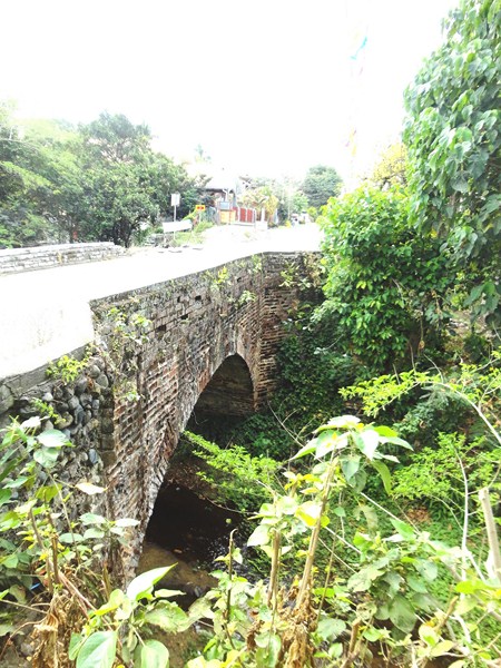
The nearly two century old, single arch Dampol Bridge

The nearly two century old, single arch Dampol Bridge

While my media colleague  Alexis Romero was busy interviewing Fr. Ferdinand E. Lopez at the Church of St. Vincent, I walked a short distance to Dampol Bridge which was said to have been built at the same time the church was being built.  Most tourists and some locals pass by it and don’t know that they are stepping upon or driving on one of Dupax del Sur’s historical treasures.

Approach to Dampol Bridge

Approach to Dampol Bridge

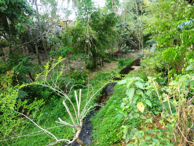
This nearly two century old, single arch unreinforced bridge that spans the Abanatan Creek which divides Brgy. Dopaj and Brgy. Dumang, was built in 1818 by the Isinai and other indigenous groups living in the area.  Its red-colored bricks were made from an old adobe workshop near the church, when Spanish Dominican friar Fr. Francisco Rocamora was vicar.

Abanatan Creek

Abanatan Creek

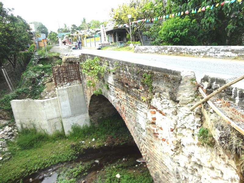
During a road construction and widening project undertaken by the DPWH -Nueva Vizcaya 2nd District Engineering Office in 2014 (who regarded the bridge as part of the National Highway), this important cultural and historical landmark was spared from demolition after an outcry from the Isinai community, but not after part of the protective brick wall had already been taken down in sections, exposing the inner filling to decomposition.

The damaged portion of the bridge

The damaged portion of the bridge

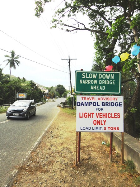
Today, only light vehicles (load limit: 5 tons) such as cars are allowed to cross the bridge, one at a time.  A suggestion to re-route traffic away from Dampol Bridge is now being considered.

Malagonlong Bridge (Tayabas City, Quezon)

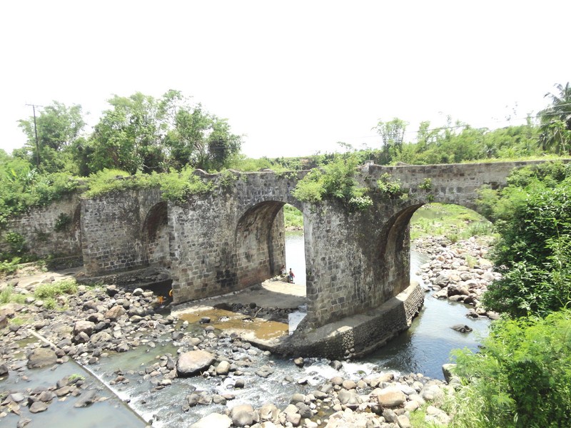
Leaving the Tayabas City proper, Jandy, Maricar, Violet, Lanny and I continued on our way to Lucban.  About 2.4 kms. outside the city, we made a stopover at the now unused, Spanish-era Malagonlong Bridge across the Dumaca-a River.  This wasn’t the first time I’ve seen this bridge, having seen it on our way to Mauban to attend the Maubanog Festival 3 years ago.

Malagonlong Bridge

Malagonlong Bridge

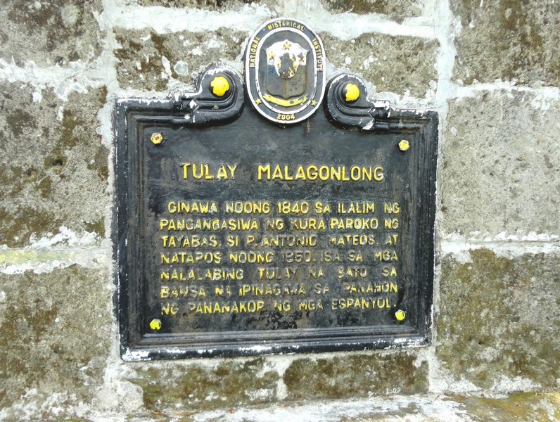
However, this would the first time I would actually explore it, crossing the bridge’s 445 ft. (136 m.) length to the other end. The first time, I just took pictures of it from the modern, girder-type concrete bridge parallel to it. On August 12, 2011, it was declared as a National Cultural Treasure under the Historic Bridges of Tayabas. On its eastern side is the plaque installed by the National Historical Institute.

The plaque installed by the National Historical Institute (NHI)

The plaque installed by the National Historical Institute (NHI)

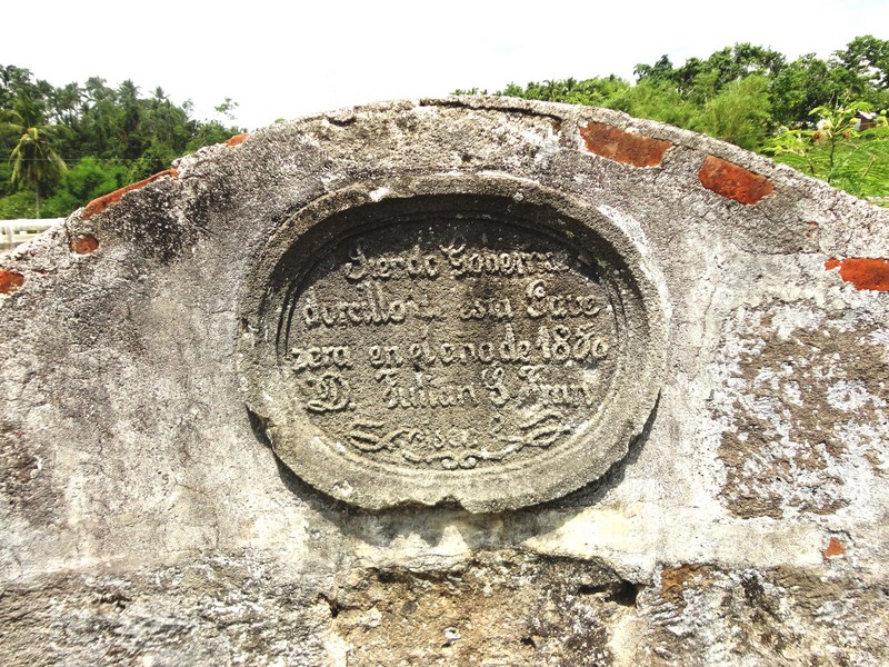
An older plaque installed at one of the bridge's balconies

An older plaque installed at one of the bridge’s balconies

The oldest in the province, the charming, ivy-covered Malagonlong Bridge (Puente del Malagonlong) is one of the few remaining and the longest Spanish colonial, arch-type bridge in the country. One of 11 Spanish-era bridges within Tayabas City, it connects Brgy. Mateuna with Brgy. Lakawon.

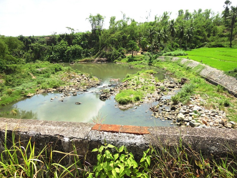
Dumaca-a River

Dumaca-a River

Built with about 100,000 adobe blocks, limestone and molasses, it was started, during the term of gobernadorcillo Don Joaquin Ortega’s term, by Spanish Franciscan parish priest Fr. Antonio Mateus in 1840 and completed 10 years later during the term of gobernadorcillo Don Julian S. Francisco. 

The bridge's 6 m. wide carriageway

The bridge’s 6 m. wide carriageway

The bridge has five spans, the first arch with a height and width of 36 ft (11 m); the second at 33 ft (10 m); the fourth at 30 ft (9.1 m) and the fifth at 18 ft (5.5 m). It has a width of about 20 ft (6 m.) and six small balconies.

The author posing at one of the bridge's balconies

The author posing at one of the bridge’s balconies

How to Get There: Tayabas City is located 147.28 kms. from Manila and 10.62 kms. from Lucena City. Malagonlong Bridge is a 15-20 min. tricycle ride from the city center.