The Surreal World of Kapurpurawan Rock Formation (Burgos, Ilocos Norte)

Kapurpurawan Rock Formation: The Sphinx-like “Head”

After our biscocho and salt making observation tour in Pasuquin, our Lakbay Norte 2 media group then boarded our bus and proceeded to the fellow Ilocos Norte town of Burgos.   From the National Rd. our bus turned towards a gravel road and traversed it for about 3 kms. until we reached a makeshift picnic hut, our jump-off point for the amazing, unique and Sphinx-like Kapurpurawan  Rock Formation, one of the best places to visit in the town, aside from the iconic Cape Bojeador Lighthouse, the country’s tallest.

Bonsai-like plants amid pools of limpid sea water

From the hut, it was a 30-min. walk, along concrete steps, dirt track and then, through a tidal pool.  At the tidal pool, sea water-filled coral rock pools, of varying sizes, and bonsai-like vegetation can be seen sporadically.  The rock formation was formed from sandstone naturally carved by weathering from wind, sand and water to create different surreal shapes such as the iconic “Head,” “Cradle” and the “Resting Dragon.” The word kapurpurawan was derived from the Ilocano root word puraw meaning “white” and these formations are said to be much whiter during the summer months of April and May.

This rock formation, possibly the “Resting Dragon,” looks
like a slithering cobra  about to pounce

Our short Kapurpurawan Rock Formation hike made us hungry and, as it was lunchtime, we proceeded to the nearby, picturesque town of Paoay for lunch at Cafe Herencia.

Check out “Restaurant Review: Cafe Herencia

Herencia Cafe: MacArthur St., Brgy. 14, Sangladan, Paoay, Ilocos Norte.  Tel: (077) 614-0214

Breathtaking Palaui Island (Sta. Ana, Cagayan)

Palaui Island

We woke up very early in the morning to overcast skies and rain.  After breakfast at the Cagayan Holiday & Leisure Resort, we all checked out of our villa.  We left our luggage at the hotel lobby for transport to the Eastern Hawaii Resort, later to be our second home in Sta. Ana.  Thus unburdened, we all boarded our CEZA coaster for the fish port at Brgy. San Vicente. Point Escarpada, in Brgy. San Vicente, the sailfin capital of the Philippines.  It has the best fishing grounds for marlin, being at the confluence of several ocean currents that carry baitfish and the larger pelagic predators that hunt them.

White sand beach at Punta Engano

At the port, 5 motorized outrigger boats were chartered to bring us to the undeveloped and seldom visited, 3,850-hectare and volcanic Palaui Island, a 7,415-hectare Protected Landscape and Seascape with a shoreline of 20.6 kms., a length of 10 kms. and a width of 5 kms..  The island is inhabited by a community of Dumagats administered by a Filipino church group and is also home to different monkeys, wild pigs, deer, sea turtle and various endemic and migratory birds.  

Cape Engano Lighthouse

The skies were still overcast when we left port.  With me in the boat was Astra Alegre, Izah Morales, Kara Santos, Nina Fuentes and Kim Madridejos.  Our 45-min. boat ride was uneventful until we reached open water when the sea suddenly became choppy, creating mild to wild panic among the other boats but childish exhilaration (except for the visibly worried Astra) with me and my companions with every rising wave.  We first made short landfall at a gray sand Siwangag Cove for some photo ops then returned to our boats for our final landfall at a gorgeous bay with a curving white sand beach and well-preserved coral.  The beach looked really inviting but we weren’t here for swimming or snorkeling.   Instead, we opted to visit its picturesque old Cape Engaño Lighthouse (Faro de Cabo Engaño), the northernmost Spanish-era lighthouse in the country.  Located on the windswept headland of Punta Engaño, it was designed by Engr. Magin Pers y Pers, started in 1887 and completed on December 30, 1892. Upon reaching the end of the beach, we began our ascent up a mildly sloping to steep trail up the 92.75 m. high, cone-shaped hill, pausing at intervals to admire the Batanes-like scenery of its surroundings.

Dos Hermanas

After a 30-min. hike, we finally reached the lighthouse.  Though now run down and a little eerie, it was obviously a sight to behold during its heyday.  The back of the lighthouse had a panoramic view of the rolling waves of the Pacific Ocean breaking on the beach and rocky shore, the rolling, green-carpeted hills below, the two rocky islands of Dos Hermanas beyond and, farther off, the Babuyan group of islands, leaving all of us awestruck by the sheer beauty of nature before us.  It was already drizzling when we went down the hill and returned to our boats.  The return trip was just as exhilarating as the previous.  Upon arrival at the port, a prepared lunch adobo and rice awaited us at the nearby picnic huts.  

Roughing it up in San Lorenzo Ruiz (Camarines Norte)

The Hike Begins …..

From the second day onwards, right after the Pabirik Festival, it was raining from time to time and heavy rain welcomed us early in the morning of the third day, the day we were to travel to the Calaguas Islands and camp overnight. A phone call confirmed our worst fears – the trip to the Calaguas Islands was cancelled due to rain and high waves.  Regretfully, we switched to Plan B – a hike to Nakali Falls in San Lorenzo Ruiz town, rain or shine.  We were all driven to the municipal hall where two guides were assigned to us by the mayor.  Amable Miranda and Roufel “Raffy” de Vera of the Provincial Tourism Office also accompanied us.  As it was still early in the morning, we expected the round trip trek to the falls to be over in four hours and that we would be back at the municipal hall by lunch time.  How wrong we were.  Regretfully, for the trek, we only brought bottled water and some snacks we bought at Daet.

Me with Kara, Raffy and our guide

The trail was understandably wet and muddy due the previous night and today’s rain and I regretted having worn slippers instead of sandals which, more often than not, got stuck in the muck.  The uphill, downhill and sometimes flat trail brought us hiking through coconut and pineapple plantations, boulder-strewn river banks as well as crossing the Matacong hanging bridge.  I also made a wrong turn along the way, hiking alone for some time before retracing my steps and catching up with them.  A number of times, media colleague Lito Cinco wanted to quit, uttering his famous line “This is where I draw the line” a number of times, only to continue on his way, goaded on by Kara Santos.

Dining on coconut meat and juice

We all finally drew the line when we neared the falls as the strong river current, even with a guide rope thrown across, prevented us from hurdling the final leg.  Even if we did, heavy rain would have prevented us from using our cameras much less get a good, clear shot.  We just contented ourselves with bathing the cool river waters.  It was now late in the afternoon and we hadn’t eaten lunch, just snacks, water and the juice and meat of some coconuts plucked from trees at a shack where we made a stopover and rested.

Contenting ourselves with bathing at the river

The thought of a late lunch waiting for us at the municipal hall plus a hot shower and warm bed at the resort goaded us to reduce the return hike from the original 4 down to 3 hours, helped along by my walking barefooted in the mud, however risky it may be.  The others made better time than us and Mark Nunez and I brought up the rear, as we finally staggered back to the town, so weak that we bought and gobbled up chocolate bars at the first sari-sari store we saw just to get us again walking the last few strides to the municipal hall.  Upon arrival,  town mayor Nelson P. de los Santos welcomed us with a much anticipated but very late lunch.  The others were already eating when we arrived.  Back at Bagasbas Lighthouse Resort, we had to coax our weary and aching bodies just to eat our dinner.  Sleep came easy to us the weary that night. Check out my Business Mirror article “Camarines Norte: 400 Years of Keeping the Faith.”


Pinatubo: Scratch This from my Bucket List (Zambales)

Our 4 x 4s  traversing dry lahar fields and small streams

Mt. Pinatubo was prominent in my Bucket List of places to visit and I readily joined the 5-day, North Philippines Visitors Bureau (NPVB) and Manila North Tollways Corp. (MNTC)-sponsored Lakbay Norte 2 Tour as it figured prominently in the itinerary.  We were now in the third day of the tour and we left Microtel Inn & Suites Luisita  (Tarlac) very early in the morning, eating our packed breakfast on our special Victory Liner bus along the way.  By 7 AM, we arrived at our jump-off point for the trek to Mt. Pinatubo’s 2.5-km. wide Crater Lake – P.D.C. (Pull Travel Destination Corp.)  Spa Town in Brgy. Sta. Juliana in Capas in Tarlac.

The Trek Begins….

Normally, trekking via the Capas Trail (the easiest route to Mt. Pinatubo), passing by lahar deserts, would have taken us a grueling 6-8 hours on foot. However, five 4 x 4, 5-pax (including our driver) all-terrain vehicles, a mix of short wheelbase land cruisers and homemade jeeps, were made available for our use.  These were to negotiate some of the watery and rocky paths across Crow Valley, unreachable by other kinds of vehicles.  The drive through the valley, though at times bumpy, was exhilarating, with spectacular views of the Cabusilan Mountain Range.   After an hour, we arrived at the base of the mountain, the jump-off point of our trek.  From here, it was to be all 2-3 hours (dependent on our fitness and ability and the size of our group) of footwork, through the valley and up a mountain path, to the Crater Lake. Normally, a very hot trek, especially during the summer months (when the light gray volcanic ash reflect the rays of the sun), we were fortunate this day as it obviously rained the day before and it was quite windy.  Just the same I applied sun block lotion and wore a cap, shorts, sturdy rubber  sandals, plus my a comfortable light blue and white MNTC-supplied T-shirt.  

A surreal but serene landscape

The trek, though very tiring, was truly exhilarating as we traversed sometimes fairly flat and dry lahar riverbeds and oftentimes rocky ground and crossed numerous small creeks and rivers by jumping from boulder to boulder or, in my case, I just getting my feet wet under the cold water (truly a different kind of experience).  After a short, final hurdle up paved steps, we reached our destination – viewpoint for observing the magnificent crater and it turquoise-colored lake created during the 1991 Pinatubo eruption.  The viewpoint was developed to cater to us tourists.

Boating at the Crater Lake

After a few minutes of rest and quietly admiring the beautiful scenery set before us, most of us went down the paved steps down to the lake where a number of us rode boats, in two trips, and were rowed to the other side of the lake by an Aeta boatman.  The others, including me, contented themselves with dipping our feet in the cool lake waters while two others (Karlo de Leon and Melissa Dizon) took to swimming its deep water. Upon the arrival of the second boat load, we all made our way back up to the rest area, bade farewell to this magnificent creation of nature’s fury and made our way back to our respective vehicles.  The return hike was easier and done in half the time it took to get there as it was mostly downhill. The uphill climb to our vehicle’s parking area was the most strenuous.  As soon as everyone was accounted for, we all returned to our assigned 4 x 4s, too tired to even take pictures, and made our way back to P.D.C. Spa Town.

The Pugad (Pugo Adventure) Tour (Pugo, La Union)

Four-wheeled, all-terrain vehicles (ATV)

We were now in Lakbay Tour’s second day and, after an art-filled first day in Baguio City, we were now in for some adrenalin pumping adventure featuring zip lines (3 to be exact) with some all-terrain vehicle (ATV) excitement thrown in at Pugad Pugo Adventure Park in Pugo, La Union.   Pugad, “bird’s nest” in the vernacular, is actually a hybrid of the two words Pugo, the name of the town, and “adventure.” We alighted from our special Victory Liner tour bus (its body sticker-wrapped with the tour’s sponsors), at the Flying V (incidentally also a Lakbay Norte 2 tour sponsor) station along Marcos Highway in Brgy. Cares in Pugo and transferred to a smaller Pugad shuttle bus.  DOT Region 1 representatives Evangeline M. Dadat (senior tourism operations officer) and Reynaldo Gesmundo (tourism operations officer II) joined us.  After a 300 m. drive over a narrow road (unfit for our big bus), we finally arrived at the resort. Though this inland swimming resort has 2 crystal-clear outdoor swimming pools (adult and kiddie), picnic cottages, clean toilets, shower rooms, conference halls and a hanging bridge over a clean river, Pugad Resort  is more known for the extreme adventure it offers. Pugad’s famous 380-m. long and 240-ft. high Super Man Zip Line 1, one of the resort’s  three zip lines, stands out as the longest zip line in Luzon and is reportedly the second longest in the country.  Rates for the 3 zip lines is PhP900 per person or PhP1,000 if it includes wall climbing and breathtaking rappelling.This was too good to miss out.

Pugad Pugo Adventure Park

But first we had to wait in line as only five people can be accommodated at a time.  While waiting, we opted to try out out the  4-wheel, all-terrain vehicles and dune buggies at the nearby dirt track.  Unlike the zip line, this was a first for me and I drove cautiously over the winding and hilly but well-designed, 2.5-km. long course with its numerous bumps and turns, at one time falling into a ditch in spite of my caution.   My other companions confidently drove like seasoned racers. However, I soon speeded up midway round the course, only slowing down as I tackled the final 4-ft. high and steep hill back to our starting point.
 
Hannah Barrios finally enjoys Zip Line 3


This initial adrenalin rush now over, it was now time for some state-of-the-art zip lining. There were no more waiting lines as only three of us were left, the other two being Studio 23’s  Hannah Barrios and Joshua “Red” Nietes, both reluctant and scared first-timers. After filling up the necessary waiver forms, we were suited up with the necessary Petzl C29 Pandion harness and Petzl helmets for our safety then bundled into the back of a pickup truck, then driven up the cliff,  We then made a short hike, up a concrete stairs, to our first zip line—the Super Man Zip Line 1 (so named because we had to do it in a flying Superman pose), the highest and the longest in duration (30 seconds) of the three.

I tried it first, as Hannah and Red  were reluctant.  Soon I was harnessed parallel to the ground and on my way. It was everything it was hyped up to be, with picturesque views of a smooth flowing, boulder-strewn river, small rice terraces and lush, forested mountains. It was sometime before Red then Hannah took the plunge but, after having done so, liked it so much that they were both first at the succeeding 2 zip lines. The 280-m. long, 160-ft. high and less picturesque Zip Line 2, the fastest among the three (10 seconds with its 100-m. descent), and the 250-m. long, 60-ft. high and relaxing, 20 second long Zip Line 3, the basic and beginner’s zip line, were both done in the sitting position.  The last passes over the swimming pool and the river before ending at the campsite. It was starting to rain when I finished the last of the zip lines, making rappelling and wall climbing out of the question as the wall had become quite slippery. Besides, it was now time for lunch at the resort’s restaurant prepared by resort owners Eugene Martin, a retired police director, and his wife Pricilla, a Pugo councilor.  Heck out my Business Mirror article “Pugo’s 3 in 1 Adventure Tour.” 
 
Pugad Pugo Adventure Park: Sitio Kagaling, Brgy. Palina.  Mobile number (0927) 667-2619.  Tel: (072) 603-1592.  E-mail: pugoadventure@yahoo.com.

A Historical Tour of Corregidor (Cavite)

Battery Hearns

Come morning, prior to breakfast, Lee and Mark opted to do some fishing as South Dock.  The fish that early morning weren’t biting and the only thing they had to show for their unsuccessful effort was a lost fish hook.   After a hearty and filling breakfast, Mark and I, with other hotel and day tour guests, joined the regular tour via tranvia.  Its itinerary included Batteries Hearns, Geary, Way and Crockett, plus the Pacific War Memorial (and its museum), Lorcha Dock and the Spanish Lighthouse.

A tranvia

Battery Hearns, a 12-inch seacoast gun, was built from 1918 to 1921 at a cost of US$148,105. One of the last major additions to Corregidor’s defense system, it had a maximum range of 29,000 yards and was capable of firing in all directions. Intended to defend the island against enemy naval threat from the South China Sea, Battery Hearns had been in action firing towards Cavite from February 1942 and, on April 8 and 9, 1942, towards Bataan. When Corregidor fell, this gun emplacement was captured nearly intact by the Japanese.  It was subsequently repaired and put back into action.  However, in January and February of 1945, it was completely neutralized by American aerial bombardment.

Battery Way

Battery Way, built from 1904 to 1913 at a cost of US$112,969, was named after 2nd Lt. Henry N. Way of the 4th U.S. Artillery who was killed in 1900 during the Philippine-American War.  It was armed with four 12-inch mortars capable of firing a 1,000-lb. deck piercing of 700-lb. high explosive shell in any direction with a maximum range of 14,610 yards at the rate of one round per minute per mortar.  Three of the serviceable mortars opened fire on April 28, 1942 and on May 2, two of these were hit.  After more than 12 hours of continuous firing, the remaining mortar finally froze tight on May 6, the last to cease firing before the surrender.

Battery Geary

Battery Geary was built from 1907 to 1911 at a cost of US$145,198. It was named in honor of Capt. Woodbridge Geary of the 13th U.S. Infantry who died in 1899 during the Philippine-American War. With a maximum range of 14,610 yards, its eight 12-inch mortars were capable of firing in any direction.  Considered as the most effective anti-personnel weapon in Corregidor, the vertical plunging trajectories of the mortars made them ideal for use against enemy entrenched on higher grounds in Bataan.  The battery had two mortar pits with 3 magazines and its standard crew consisted of 4 men per mortar.

Battery Crockett

Battery Crockett, one of the 6″ disappearing” gun batteries that formed the interlocking field of fire which totally encircled the island, was built from 1905 to 1908 at a cost of US$290,049. Armed with two 12-inch seacoast guns mounted on disappearing carriages behind a concrete parapet, this battery basically fired south across the major southern channel into Manila Bay.  It had a range of 17,000 yards and was capable of a 170-degree traverse, with overlapping fields, or a total of 220 degrees coverage for the battery. Similar to Battery Cheney and Battery Wheeler in design, it was centrally located on the island.

Pacific War Memorial

The Pacific War Memorial, standing on the highest part of Corregidor, on the island’s west,  was built by the U.S. government and completed in 1948 at the cost of US$ 1,230,000.  It is dedicated to the Filipino and American soldiers who shed their blood on Corregidor. The memorial’s dome has an opening at the top through which sunlight shines through to exactly fill a circular altar on the week of May 6, the Fall of Corregidor. Left of the acacia tree-shaded entrance is the Cine Corregidor Ruins and behind it is a small, modest marble museum containing war relics, photos, a documentary film projection room, souvenir shop and descriptive information.

Eternal Flame

To the right of the museum is the remains of the Bachelor Officers’ Quarters and the Post Headquarters.  Within the complex is the steel wing-shaped sculpture Eternal Flame designed by Greek-American sculptor Archimedes Demetrius. The flagpole, originally a mast of a Spanish warship, was salvaged by Admiral George Dewey after the Battle of Manila Bay, and had it planted in Corregidor.  It is where the American flag was lowered during the surrender and raised again during the liberation.  The American flag was lowered for the last time on October 12, 1947 and the Philippine flag was hoisted in its stead.

Lorcha Dock

Lorcha Dock, situated near Gen. Douglas MacArthur Park (has a life-size bronze statue of the general), is often referred to as The Army Dock or MacArthur’s Dock.  It was at this dock where, on March 11, 1942, Gen. Douglas MacArthur boarded PT Boat 41, under the command of Navy Lt. John Bulkeley, for Australia.  The Spanish Lighthouse, located on the highest point of the island (628 ft. above sea level), is a reproduction of the old lighthouse built in 1897 but destroyed during World War II.  It has a commanding view of the island.  We previously visited the lighthouse and the Pacific War Memorial during the Adventour.

Mark tries out the ROCKet zipline

After the tour, we returned to the hotel for lunch and check out.  After lunch, all four of us, together with Jovy and Mat, proceeded to the Mile Long Barracks for additional photo ops and, prior to our leaving, Mark (a first for him) and I tried out the ROCKet Zipline (http://www.benjielayug.com/2009/12/launch-of-the-rocket-zipline-corregidor-cavite.html).  a 40-ft. high, 300-m. long free-fall cable ride.  Gravity-propelled and with rocket-like speed, it stretches from Corregidor Inn to the South Beach.  This piece de resistance truly capped two adrenalin-fulfilling days in the historic, and now adventure-filled, island of Corregidor.

Sun Cruises, Inc. (SCI) – Reservation Office: CCP Terminal A, CCP Complex, Roxas Blvd., Manila.  Tel: (632) 831-8140 and (632) 834-6857 to 58.  Fax: (632) 834-1523.  E-mail: suncruises@magsaysay.com.ph.

Sun Cruises, Inc. (SCI) – Sales Office: 21/F,  Times Plaza Bldg., Ermita, Manila.  Tel: (632) 527-5555 local 4511 and 4512.  Fax: (632) 527-5555 local 4513.  E-mail: sales@suncruises.com.ph.

Beijing Zoo – Asian Games Panda House (Beijing, People’s Republic of China)

After having our fill of Peking Roast Duck at the Original Quanjude Restaurant, we returned to our coach and proceeded to the Beijing Zoo where we were to have our first face-to-face encounter with the Giant Panda, an emblem of China, at the Asian Games Panda House. We entered the Zoo’s East Area where the pandas, big cats, bears, small mammals, pheasants and waterfowl are housed.

Beijing Zoo Entrance

The over 10,000 sq. m. Asian Games Panda House, built in 1990 for the 11th Asian Games, currently houses 5 pandas, the youngest being 2 years old. The Giant Panda Hall is designed on a circular pattern inspired by the Tai Chi symbol. The interior has area of 1,452 sq. m. and there is an additional 2000 sq. m. of outside “playgrounds” for the pandas with trees, climbing structures, and lots of places to lean back and enjoy a snack.

Asian Games Panda House

The main part of the house has a bamboo-shaped structure, entered from the southeast side and exited from the northwest, with 11 semicircular arch rings (representing the 11th Asian Games) surrounding it. There are 3 exhibition rooms around the central hall. The center also has rooms for isolating, medical treatment, fresh bamboo, deliveries, food making and TV supervision.  The outdoor sports ground has wooden perches and recreational facilities for pandas.  Bamboo is grown around the Panda House.

A Sleeping Giant Panda

The Giant Panda (Ailuropoda melanoleuca) is a bear easily recognized by its large, distinctive black patches around the eyes, over the ears, and across its round body. Though it belongs to the order Carnivora, the Giant Panda’s diet is 99% bamboo. Other parts of its diet include honey, eggs, fish, yams, shrub leaves, oranges, and bananas when available.

The Giant Panda in Motion

It lives in a few mountain ranges in central China, mainly in Sichuan province, but also in the Shaanxi and Gansu provinces. Due to farming, deforestation, and other development, the Giant Panda has been driven out of the lowland areas where it once lived. The Giant Panda is a conservation reliant endangered species. While the dragon has historically served as China’s national emblem, in recent decades the Giant Panda has also served as an emblem for the country. Its image appears on a large number of modern Chinese commemorative silver, gold, and platinum coins. Though the Giant Panda is often assumed to be docile, it has been known to attack humans, presumably out of irritation rather than predation

Patag Valley (Silay City, Negros Occidental)

On our last day in Silay City, I, together with my wife Grace and children Jandy and Cheska, decided to do some trekking at Patag (meaning “flat plain” in the vernacular) Valley, located 45 kms. from Bacolod City in a valley 1,600 ft. (490m.) above sea level, between the highlands of Mt. Silay and Mt. Marapara.  After breakfast at Balay Daku, my grandfather’s ancestral house, we left by 7:30 AM and were accompanied by Neil Solomon “Solo” Locsin, my young first cousin, who was familiar with the place.  During World War II, the valley was a battlefield, being the last stronghold, in the whole region, of the Japanese Imperial Army’s Nagano detachment.   Here, 15,000 Japanese and hundreds of Filipino and American (from the U.S. 40th Division) soldiers died.  The Japanese surrendered after 5 months.  Today, a wide Japanese altar commemorates the last battle between the two forces and underground, manmade Japanese tunnels can still be found.  

The Von Einsiedel Resthouse


Throughout the 32 km., 1-hour trip, east of the city, to the valley, we passed huge expanses of sugar fields.  We first made a stopover at the beautiful resthouse of Milou von Eisiedel, another first cousin of Neil and I.  Designed by her husband and fellow U.P. alumni and architect Nathaniel “Dinky” von Einsiedel, the a resthouse had two bedrooms, living and dining area, kitchen, a mezzanine and a huge balcony that overlooks a terraced garden with beautiful flowers below and the verdant valley and mountains beyond.  

Returning to our car, our driver then drove us up to the end of a dirt road.  From hereon, it was all footwork as  we were to trek to a waterfall.  Leading the way, Solo guided us along a well-marked but slippery trail.  We were all wearing shorts which seem unsuitable as it exposed our legs to scratches from prickly plants and sharp rocks.  At one time, we had to wade through a stream made murky by an unsightly dam.  This aside, everything else was beautiful as we passed small waterfalls and beautiful turquoise-colored streams After 30 mins. of continuous hiking, we finally arrived at a beautiful, 25-ft. high waterfall.  This was as far as our schedule would allow and, after some photo ops, we retraced our steps back to the car. 

This short tour perked up an appetite to explore the valley, in more detail, sometime in the future.  The valley is a favorite for ecotours, it being a base for exploring stretches of rain forest and some of its 300 waterfalls, the most beautiful of which is the breathtaking Pulang Tubig Waterfalls (not in our itinerary though, being too far out) whose waters seems red in color because of its red or orange rocks it falls unto.  The valley is also home to sulfataras (sulfur geysers) and endangered species of wildlife including the Negros spotted deer (cervus alfredi).  This is also the jump off point for the hike going to Tinagong Dagat (Sipalay City) or Mt. Mandalagan and a site for Boy Scout Jamborees and Red Cross Training.

Return to the Hundred Islands (Alaminos City, Pangasinan)

View of Islands from View Deck

The last time I’ve been to the Hundred Islands in Alaminos City, Pangasinan was way back March of 2005, Holy Week with son Jandy and 2 lady friends, and we only got to explore 3 of its islands, camping overnight at Marta Island. I considered this a poor batting average considering that there are 127 of these granite and scrub-covered islands and islets, a number of them having white sand beaches.  Again it was Holy Week and this time I, together with Jandy and daughter Cheska, found ourselves in Pangasinan, staying at El Puerto Marina Resort and Spa at the provincial capital town of Lingayen.  The resort offered day tours to the islands and we decided, especially Cheska who was a first-timer to these islands, to join the tour.  Our group included Fil-American Ms. Katrina Nogoy and Malaysian-American Ms. Janet Jun Siew Loh, both visiting school teachers from Japan.  Our guide was resort employee Mr. Viramel “Ram” Velasco. 

Lucap Wharf

The trip, via a van driven by Mr. Nixon Fernando, to Brgy. Lucap, take-off point to the islands, took all of 1 hour. Again, it being a long holiday, the wharf and every island with a white sand beach was packed with tourists.  Although I brought a 5-pax tent with me to Lingayen, camping on an island was out of the question.  However, we decided to explore beyond the normal tourist boat route which only included the partially developed Children, Governor’s and Quezon Islands, this time including the other outlying but interesting islands, paying a hefty PhP800 to do so.  While waiting for our boat, I made a short visit to Lucap’s Marine Museum which has a collection of corals and other marine life.  This 1,844-hectare national park, declared as such on January 18, 1940 through Proclamation No. 667, is believed to be the second largest marine reservation in the world with 2,000 species of marine life.

Lucap Wharf Marine Museum

The whole park can be readily covered, even by a slow banca, in half a day.  Most of the islands we passed are small (the smallest being less than 20 sq. m.), heavily-undercut at the base and have an elevation of 20 m. .  Many do not have trees to shade you from the sun and do not carry a name.  Some that do carry names are fancifully named after luminaries in the country (Marcos Island, Romulo Island, Quezon Island, etc.) while others are named after plants and animals that they resemble (Mushroom Island, Turtle Island, etc.).  An interesting photo opportunity was Cathedral Island, so named after its cathedral-like, fruit bat-inhabited cave with domed rock formations.  

Cathedral Island and Cave

Our first stop was Governor’s Island.  The island had white sand beaches on both sides but lolling around at the packed beaches wasn’t yet in our agenda.  Instead, all five of us decided to climb up the top of the island which, unlike 5 years ago, now had paved stairs and roped railings leading to a concrete view deck with railing (and packed with tourists).  What hasn’t changed, though, was the magnificent and panoramic view it afforded of this mini-archipelago said to have been formed from the tears of a prehistoric lovelorn giant who pined for his lost lady love.   The island also has a not-too-deep, sea-sculpted cave.

Marcos Island

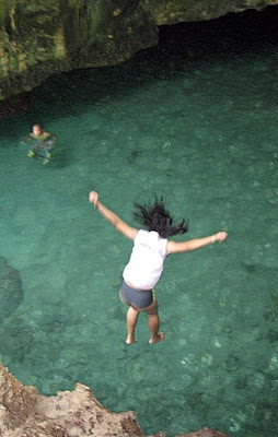
Our next and longest stopover was Marcos Island.  Marked by mermaid statues, the island consists of 3 mounds, a 70-foot drop-off, a nice white sand beach (difficult to land on when the waves are high) and a helipad on the smaller dome.   From the beach, a well-marked trail, on the left, leads to the top of the island where its chief attraction is the bat-inhabited Imelda Cave which can be peered down from a blowhole above. Here, the adventurous and brave could climb down a wooden stairs to a ledge where they can cliff dive to the sea below.    

Waiting in line for our cliff dive
All five of us took a shot at it but the visibly scared Katrina and Jandy (although he knows how to swim) donned life vests just in case.  Upon hitting its suitably deep waters, we swam or clung to the cave walls, out to the cave mouth and back to the white sand beach.  Although Janet and Katrina only tried it once, we liked it so much that we went back for second shots (Cheska tried it thrice).  With our adrenaline rush sated, we finally settled down to lolling around in the rock-shaded portion of its beach. 
Cheska taking the plunge

It was now noontime and, after this exciting but adrenalin-sapping exercise, we were visibly hungry, our previous meal being an early breakfast at the resort.  We got back to our boat and proceeded to Quezon Island (at 25 hectares, the largest in this mini-archipelago).  This most frequented island was truly packed to rafters with tourists as it had, aside from its white sand beach, a pavilion for guests, stores (where one could dine) and toilet and bathing facilities (for a fee).  Again, it being a holiday, prices of goods bordered on the cutthroat but, hungry as we were, still ordered cooked Spam (at PhP250, twice that in Manila) plus rice (at PhP25 per cup) washed down with half-liter bottles of water (at PhP60).  The island also has a nursery for giant clams (locally called taklobo), a demonstration site for 300 clams dispersed here and at Children’s and Governor’s Islands, and all monitored on a regular basis. These, as well as the corals and mangroves, were rehabilitated through a program called “Marine Biodiversity Enhancement,”  a project of the Philippine Tourism Authority (PTA), the University of the Philippines Marine Science Institute (UPMSI) and the Marine Environment and Resources Foundation (MERF). 

Cuenco Island and its Cave
Backed at our boat, we passed by, but did not land, at the similarly packed Children’s Island which has a walkway and a calm, nearly wave-free shoreline suitable for children (hence its name). Cuenco Island, also called Quinco Island, was our last stopover.  This interesting island has two white sand beaches, on two sides, and a huge cave that passes through its center. 

Isla Malipano (Island Garden City of Samal, Davao del Norte)

On our second day at Pearl Farm Resort, Grace, Jandy, Cheska, my in-laws and I decided to crossed over (a 2.5-min. boat ride) to the secluded, 7-hectare Isla Malipano and check out its facilities.  We were dropped off at the 200-pax, octagonal and multi-functional Malipano Gazebo at the other end of the island, a perfect alternative for weddings, theme parties and other occasions.  My in-laws decided to stay here while we went around the island.

Check out “Resort Review: Pearl Farm Resort” and “Pearl Farm Resort

Malipano Gazebo

Also a part of the resort, Isla Malipano has a white sand beach, an offshore reef plus 7 lavishly-decorated, 3-storey private luxury villas, each with a wide veranda with breathtaking views of the Davao Gulf. Small barbecue parties can be held at the veranda.

Check out “Resort Feature: Malipano Villas

The island’s sparkingly white sand beach

The villas are composed of 3 octagonal structures with reception areas, guest suites and dining area, all around a cantilevered deck. Their roof design is patterned after the salakot (traditional Filipino hat).  Four of the villas are perched on stilts directly above the sea while the 3 other villas are built over rock outcrops on the beach.

The Malipano Villas

Five villas have 3 bedrooms (with 2 queen-size beds and 2 single beds or 3 queen-size beds) while 2 villas have 4 bedrooms (with 3 queen-size beds and 2 single beds or 4 queen-size beds).

Veranda with a great view

All villas are airconditioned and equipped with minibar, coffee and tea making facilities, safety deposit box (at the master’s bedroom), cable TV, hair dryers, spacious living room and toilet and bath (the master’s bedroom has a bathtub).  Butler service is available for food orders and other guest assistance while a standby speedboat is available to transport guests to the restaurant and other resort facilities.

One of the villa’s master bedrooms

The island is also ideal for scuba diving as the wrecks of two World War II Japanese freighters are located 60 m. away and in front of the resort.  The 40-m. (132-ft.) long Wreck I is located just a few meters from the resort’s Samal houses, in 35 m. (115 ft.) of water.  Here, you can find groupers, jacks, moray eels and others.  For advanced divers, an open bay hatch allows safe penetration.   It is also recommended for underwater photography.  The slightly smaller, 35-m. (115-ft.) long Wreck II rests on its side at a shallower dept of 28 m. (98 ft.) of water.

Pearl Farm Resort: Kaputian District, Island Garden City of Samal, Davao del Norte.  Tel: (082) 221-9970 to 73.  Fax: (082) 221-9979.  E-mail: pearlfarmresort@fuegohotels.com.  Website: www.pearlfarmresort.com.  Davao Citysales office: G/F, Anflocar Corporate Center, Damosa Bldg., Lanang.  Tel: (082) 235-0876 and 234-0601.  Fax: (082) 235-0873.  E-mail: dvosm@pearlfarmresort.com.  Manila sales office: 15/F, 1504 Corporate Center, 139 Valero St., Salcedo Village, Makati City.  Tel: (632) 750-1896 and 98.  Fax. (632) 750-1894. E-mail: mlasm@pearlfarmresort.com.