Sta. Cruz: Laguna’s Provincial Capitol

Laguna Provincial Capitol

It was already late in the afternoon when Jandy and I arrived at Sta. Cruz town, Laguna’s provincial capital and one of the province’s 2 main route centers (the other is San Pablo City). The health, education, transportation, commerce and social services center for the entire province, Sta. Cruz also serves as the business and commercial hub particularly for the predominantly rural northeastern towns of Cavinti, Famy, Luisiana, Mabitac, Majayjay, Nagcarlan, Pakil and Pangil.

Sta. Cruz Municipal Hall

Formerly a part of Lumban, it became a separate municipality in 1602 and was made into the provincial capital in 1858, replacing Pagsanjan.  This town is made famous for its delicious kesong puti (salty white cottage cheese).  This native delicacy, made from carabao’s milk, is cooked in large vats to which salt and vinegar is added till it curdles.  The cheese is then fermented, strained and molded and then individually wrapped in banana leaves.

Church of the Immaculate Conception

Upon arrival at the town, I parked the Revo across the blue and white municipal hall at the town plaza.  The town’s layout seems to be broader than most Laguna lakeside settlements. Sta. Cruz, however, has no natural tourist attractions, only man-made.   Near the plaza is the Church of Our Lady of the Immaculate Conception.

Check out  Church of Our Lady of the Immaculate Conception

Old Provincial Capitol Building

After merienda at a MacDonald’s outlet nearby, we proceeded to visit the Provincial Capitol Building along P. Guevarra St..  Also within the compound is the old provincial capitol.  Our visit to Sta. Cruz capped our Laguna joy ride and we proceeded on our 87-km. drive back to Manila.

Mayor’s Office: Municipal Hall, Poblacion, Sta. Cruz,  Laguna.   Tel: (049) 808-1008


A Walking Tour of Mauban (Quezon)

The Municipal Hall

We finally arrived at Mauban, at the midst of its Maubanog Festival, by 4 PM and we made a stopover at the municipal hall were we all dropped by the Municipal Tourism Office and paid a courtesy call on Mayor Fernando Q. Llamas, the uncle of our good friend Lee Llamas.  Prominently displayed outside the municipal hall is an old cannon, 1 of 3 (the other 2 are at the Museo ng Mauban) bestowed by Spanish Gov.-Gen. Rafael Maria Aguilar to the town as a reward for the rescue efforts done for the Spanish friars captured by Moro pirates. The cannon were later used against the Spanish to effect the surrender of Tayabas to the revolutionaries in 1898.  All 3 were  restored on April 16, 2004.  

Traditional Mauban products

After our courtesy call on the Mayor, we  all dropped by the Mauban Product Development Office, beside the municipal hall, to check out the town’s traditional products such as finely-crafted nilala woven hats, baskets, slippers, wallets, bags, boxes, caddies, etc.;  delicacies such as pinangat, binalawan, pinais, tikoy, kalamay, pastillas, botarts, mazapan, suspiro, etc.; and nipanog, wine made with sasa (toddy palm nectar) instead of coconut and available in different flavors such as liputi, katmon, guyabano, mango, pineapple, guava, jackfruit, kalamias, tamarind and santol. Being a fiesta, booths selling these products, and more, were found in front of the municipal hall as well as along the major streets. 

Church of St. Bonaventure

While they were checking out the products, I took time out to visit the town’s present, modern Church of St. Bonaventure (the town’s patron saint).   This church underwent a lot of rebuilding since it was first built in 1647 and demolished in 1769.  The second structure, built in 1773, was badly damaged during the 1830 earthquake and rebuilt between 1836 and 1845.  The church collapsed during the July 1880 earthquake and the present church was built in 1891.  The bell tower, built in 1773, was seriously damaged during the 1880 earthquake and the portion that remained was partially destroyed again during the August 20, 1937 earthquake. 

Gat Uban Park

With the sun still up, we still had time to make a walking tour to Gat Uban Park, at the end of Gomez St., along the sea wall.  The park has a seaward facing statue the legendary Dumagat warrior and leader Gat Pangil who defended the town against ruthless Moro attacks.  Gat Pangil was also known as Gat Uban because of his gray hair (uban).  Accordingly, the town was named after the fact.  The well-lighted promenade area, with its gentle sea breeze, is a favorite meeting place for Maubanons. 

View from Rizal Hill Park

It was near sunset when we dropped by Rizal Hill Park (locally called Calvario Hill), along San Buenaventura St. in Brgy. Rizaliana.  To get to the top, we had a  choice of taking the shorter route (climbing a steep concrete stairway) or the longer route via a winding ramp skirting the hill.  Of course, we chose the latter.  At the top of the hill is a statue of National Hero Jose Rizal, erected on December 1912 by the Mauban Circle Association of Students.  The  park offers a panoramic view of the whole town.  In olden times, the hill was used as a sentinel post and a place for religious activities during the Spanish era, as headquarters by American troops, as an outpost by the Philippine Constabulary during the Japanese Occupation and, after the war, by the Civilian Emergency Administration.

Rizal Hill Park

Soon after our arrival,  Mr. Ludovico Badoy and Ms. Carminda R. Arevalo, Executive Director  and Officer-in-Charge (NHCP Research, Publications and Heraldry Division), respectively, of the National Historical Commission of the Philippines (NHCP), formerly the National Historical Institute (NHI), also arrived.  They supervised the installation of a historical marker recognizing the hill for its historical significance.  The marker was to be unveiled the next day, with Mayor Llamas and Mr. Badoy leading the ceremony.  It was now evening when we left the hill and, after dinner at the house of Mayor Llamas, we were billeted for the night at the nearby Llamas ancestral house.

Municipal Tourism Office – Municipal Hall, Poblacion, Mauban, Quezon.  Tel: (042) 784-1205 and 713-0314.  E-mail: gat_uban@yahoo.com.

The Busig-on River (Labo, Camarines Norte)

Nipa palms along the Busig-on River

We left Quinamanukan Island by 3:15 PM, the mainland just a 30-40 min. boat ride away.  Upon reaching the mainland, our boat made its way inland via the wide but sometimes shallow Busig-on River (the province’s longest river system), its muddy banks lined with nipa and coconut palms and backdropped by the 997 m. high Mt. Balagbag (known as the “Sleeping Giant”).  Every now and then, small, outrigger-less and high-bowed bancas would pass us by.  After negotiating a bend in the river, we finally reached port by 4:30 PM.  Amable Miranda of the Camarines NorteTourism Office was already waiting for us there.  After dining on angko, a local delicacy I bought and shared with the others, Amable drove us to Tabea Reichan Restaurant at Vinzons town proper where we had our “late” lunch.  After picking up our luggage at the Municipal Guest House along Bagasbas Blvd. in Daet, Amable drove us to the nearby, upscale Bagasbas Lighthouse Resort, Daet’s premier resort, where we were to stay (my second) for two days.

Tabea Reichan Restaurant: Poblacion (just across the municipal hall), Vinzons, Camarines Norte

Bagasbas Lighthouse Hotel Resort: Bagasbas Blvd., Daet, Camarines Norte.  Tel: (054) 441-5855.  Mobile number: (0916) 520-6783.  E-mail: info@bagasbaslighthouse.com. Website: www.bagasbaslighthouse.com.

Back to Camarines Norte

Municipal Guest House

For the third time this year, I was again invited to visit Daet, in Camarines Norte, this time to cover its Pinyasan Festival as well as the 150th birth anniversary of Jose Rizal, the town being the site of our National Hero’s first monument.  I was joined by event organizer Mr. Bernard Supetran, professional photographer Mr. Lee Llamas, travel writers Mr. Timothy Jay “TJ” A. Ibay of What’s On and Ms. Karla Marcia Rey, and travel blogger (and Karla’s boyfriend) Mr. Orlando “Lan” Cajigal.   We all left via a 9 PM airconditioned bus at the Philtranco terminal in Pasay City, all sitting at the rear of the bus.  This was to be my first long-haul bus (8-9 hrs.) trip to Daet, my first being by plane to Naga City (plus a 2-hr. van drive back to Daet) and the two others by van.

Surfer’s Dine Inn

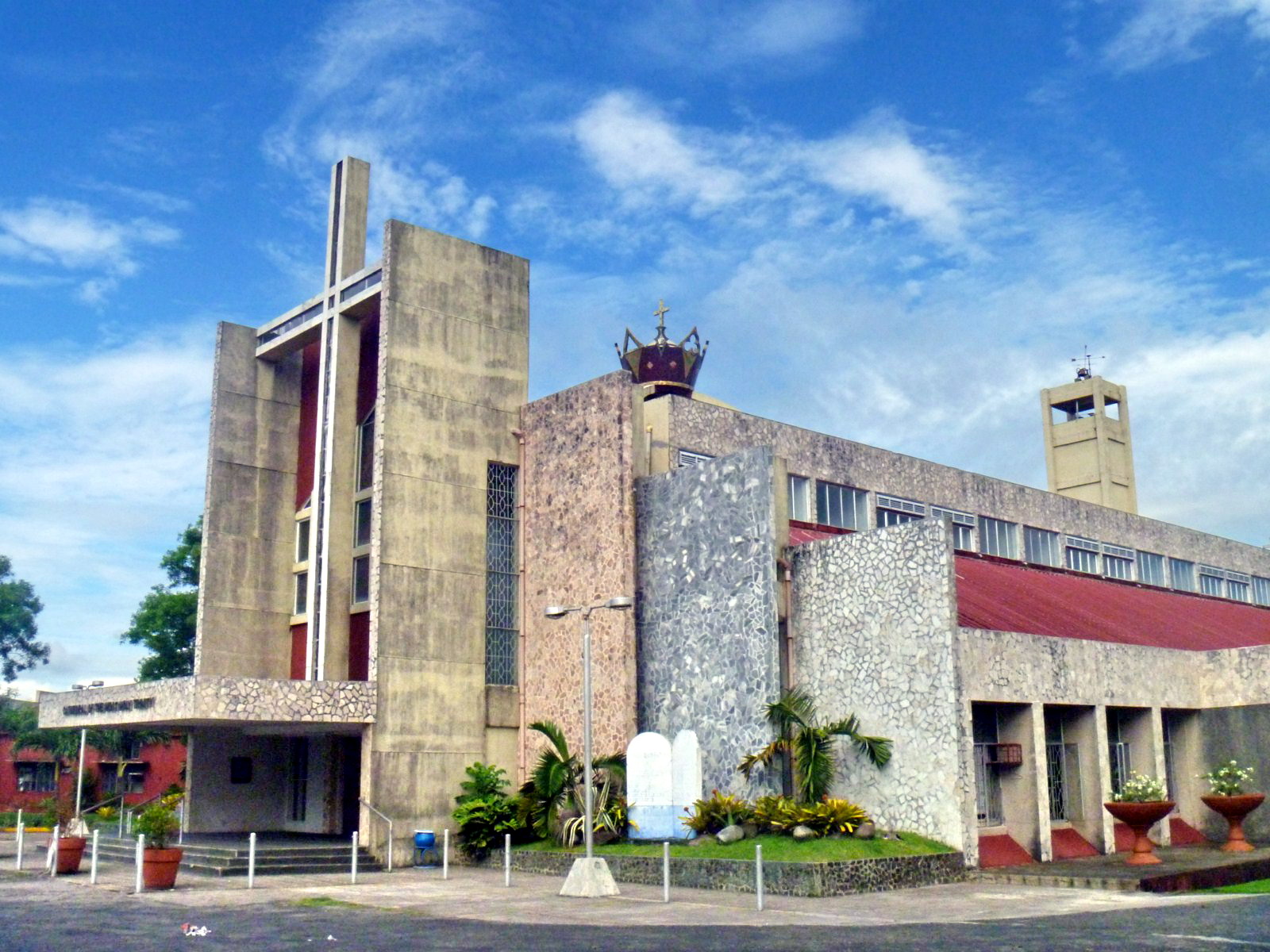
Our 6 AM arrival at Daet was heralded with a crash as our bus’ roof  scraped the low ceiling of the bus shed.  Poor bus driver (salary deduction).  Our trusty driver from the Provincial Tourism Office, Mr. Amable Miranda, was on hand at the terminal to pick us up with a van.  We were first brought to Surfer’s Dine Inn, along Bagasbas Blvd., for an early Filipino breakfast (mine was pork chops). Here, we were met by Provincial Tourism Officer and good friend Atty. Debbee Francisco.  Amable then brought us to the Municipal Guest House, also along Bagasbas Blvd., where we freshened up and rested for a short while.   We were all slated to go overnight camping at Tinaga Island, one of the famed Calaguas Islands.  This was to be my second visit and the first for the rest.We left Bagasbas by 8 AM for the leisurely drive to Minaongan Fish Port in Paracale, bringing along just enough personal necessities for our overnight camping (plus some borrowed pillows and blankets from the guesthouse).  The national highway unusually passed through the gated property (which was closed at night) of the modern Cathedral of the Most Holy Trinity (consecrated on  September 1, 1984).  Here we made a brief stopover for photo ops.

Cathedral of the Most Holy Trinity

Cathedral of the Most Holy Trinity

Chao Phraya River Cruise (Thailand)

After our Wat Phra Mongkhon Bophit tour in Ayutthaya Historical Park, we all returned to our coach and were all brought to Potangtai Pier near Bangsai (the royal folk arts and handicrafts center) for the start of our 2.5 hr. Chao Phraya River cruise from Ayutthaya back to Bangkok on board the modern and luxurious cruiser Grand Pearl.  From Ayutthaya, we would be passing through Pathumthani and Nonthaburi provinces before arriving in Bangkok.

The Grand Pearl

On board, we were in for a late but delicious buffet lunch of mostly spicy Thai and international cuisine served within the luxurious confines of the cruise boat.  All 4 of us sat in a comfortable, u-shaped booth beside a large viewing window.

Dining, Buffet-Style, on Thai Cuisine

Throughout our lunch, we watched the scenery along the banks Chao Phraya River banks within the refreshing airconditioned cabin lounge.  By 3:30 PM, midway through our cruise,  a refreshing beverage of tea or coffee and cookies were also served to the guests.

The Airconditioned Cabin Lounge

After our filling lunch, some guests proceeded to lounge at the wooden sun deck  at the front of the cruiser while the majority, including us, opted to remain in airconditioned comfort at the cabin lounge.

The Sun Deck of the Grand Pearl

Sometimes, I would also go up the sun deck, amidst the fresh cool tropical air and warm, afternoon sun, to get an amazingly clearer view of the life of the inhabitants that dwell along the river and the unforgettable scenery of children as they greet the visitors going by.

Houses Mounted on Stilts

We would watch various kinds of river craft, from barges, smaller wooden pleasure cruise boats to traditional, long-tail boats, their engines invariably mounted on an inboard, turret-like pole which can rotate through 180 degrees, allowing steering by thrust vectoring.

Long-Tail Boats

The architectural scenery also varies; from simple houses on stilts to modern villas, to modern medium-rise (Mandarin Oriental Hotel) and high-rise (The Peninsula Bangkok) hotels, from traditional Thai temples (the graceful Wat Arun,  Wat Kanlayanamit, Wat Rakang Khosittaram, Wat Pathum Khongkha) to old Roman Catholic churches (Church of the Holy Cross) and from magnificent palaces (Grand Palace, Bang Khunprom Palace, etc.) to engineering marvels (King Rama VIII Bridge).

Royal Barge Museum

The Royal Barge Museum, on the banks of the Bangkok Noi Canal , is a huge boathouse that displays 8 finely-crafted Thai royal barges (including 4 for the king). The majestic Suphannahongsa (“golden swan,” the personal barge of the King, carved out of a single teak tree trunk, was completed in 1911.

King Rama VIII Bridge

The asymmetrical, cable-stayed, 2.45 km. long (including approach spans) Rama VII Bridge, opened on September 20, 2002, has a single, inverted Y-shaped tower, a sleek superstructure and gold-colored suspension cables arranged on single and double planes.

Bang Khun Phrom Palace (Bank of Thailand Museum)

The Baroque cum Art Nouveau Bang Khun Phrom Palace, the former residence (until 1932) of HRH Prince Paribatra Sukhumbhand, the 33rd son of King Chulalongkorn (Rama V), now houses the Bank of Thailand (BOT) Museum. The museum has 14 rooms many of which display the history of Thai currency and the Bank of Thailand.

Wat Arun

Wat Arun, recognizable by its central, 66.8 m. high prang (Khmer-style tower) topped with a 7-pronged trident, was started in 1809.  It is called the “Temple of the Dawn” because the first light of morning reflects off the surface of the temple with a pearly iridescence.  By the side of the river are 6 Chinese-style pavilions made of green granite and containing landing bridges.

Wat Rakang Kosittaram

Wat Rakang Kosittaram (Temple of the Bells), built during the Ayutthaya period, was later reconstructed and upgraded as a Royal Temple by King Taksin. The main features of the temple is the bell tower whose bells gave the name temple the name “Rakang” (Thai for “bell”).

Wat Kalayanamit

The massive, mid-nineteenth century  Wat Kalayanamit is well known for its 15.45 m. high and 11.75 m. wide Phra Buddha Trai Rattana Nayok (Luang Po To), called Sum Po Hud Kong in Chinese, which is Bangkok’s biggest Buddha image.

Sunanthalai Building (Royal Seminary)

The elegant, century-old Neo-Classical Sunanthalai Building, within the compound of Rajini School (the first girl’s school operated by Thais, founded by Queen Saowapa), was built  by King Rama V in memory of Queen Sunantha Kumariratana who drowned in the Chao Phraya River  on May 31, 1880.  It was restored after a fire in 2005.

Church of the Holy Cross

Nestled among old houses on the river banks and newer buildings inland, recognizable by its reddish dome, is the Church of the Holy Cross (Santa Cruz Church), one of Bangkok’s many old Catholic churches.  First built in wood in 1770 during the reign of King Taksin (1867–1782), it was rebuilt in 1835.  The present church, built in 1916, was designed by Italian architects Annibale Rigotti and Mario Tamagno.

River City Shopping Complex

Other sights along the river include  Thammasart University (Tha Prachan Center), Pom Pra Athit, and the Holy Rosary Church (the oldest Catholic Church in Thailand, also known as Wat Kalawar).  Our cruise ended when we docked at the River City Shopping Complex Pier, Si Phraya in Bangkok by 5 PM.  Altogether, it was a worthwhile experience.

Grand Pearl Cruises: 19/394 Chaovalitr Village, Rimklong Bangkor Rd., Chomthong, Bangkok, Thailand.  Tel: 084-1361199 and 081-9005429.

The Famous Salt Beds of Dasol (Pangasinan)

The famous salt beds of Dasol

After our lunch and ocular visit of Dasoland, we again boarded our van to finally make our way back to Manila.  Its been a very busy and educational three days in Pangasinan. However, we haven’t traveled far when we espied the famous salt beds of Dasol.  We therefore stopped along the highway to take pictures of these fascinating man-made creations.  The  province’s name was derived from the word panag-asinan (“place where salt is made”) and Dasol is one of only four Pangasinan towns (the others are Anda, Bani and Bolinao) that produce salt.

Baskets of raw salt

These salt beds, glistening whitely in the late afternoon sun, have sluices that are opened to allow about 3 inches of sea water from  the incoming ocean tides of Dasol Bay to pour into and be trapped in a checkerboard of shallow ponds lined with grayish-brown clay and paved with shards of clay pots, similar to inland rice paddies.  The impounded water is allowed to naturally evaporate in the sun for a few hours, after which thin crusts of salt crystals would form on the surface and sink to the bottom of the pond.  The resulting encrusted salt is then raked, gathered into small neat piles, scooped into baskets and then transferred to a bigger pile in a hut.  The raw salt is then brought to the cooking sheds to be washed, boiled and condensed into pure rock salt. During the rainy season, the salt beds are converted into fish ponds.

Balingasay River (Bolinao, Pangasinan)

The clean, multi-awarded Balingasay River


On the way back to the Tourist Center from Enchanted Cave in Bolinao, we made a short stopover at a bridge to photograph the 7-km. long, pristine and now fishpen-free Balingasay River (Brgy. Balingasay),  twice winner of the Gawad Pangulo sa Kapaligiran Award for inland bodies of water in the Ilocos Region and a recipient of the highly prestigious Wetlands Conservation Award in 1994. Set aside as a protected seascape, this river, noted for its scenic beauty and biodiversity, has 15 hectares of century-old and new growth mangroves areas, 30 hectares of of attap palms (used for nipa hut roofing), wild ferns and balete trees hanging into the water.  These protect the river from erosion and pollution.  Different species of wild birds (locally called kiaw and pagaw) also make their home atop the trees and wild ducks, lizards, monkeys and wild boar also make their home in the forest.

Some boats parked at the river mouth

The Balingasay River is fed by Quibuar Spring, Bolinao Falls and several other springs and creeks. Fresh water meets the sea water of the South China Sea toward the middle of the river,  a perfect environment for unique fish (malaga, lapu-lapu, etc.) and shellfish (crabs, shrimps and oysters) species to flourish.  Boats from the bridge can be rented (PhP500) to explore the river which connects 5 villages to the town proper, located 5.5 kms. from the mouth of the river. Aside from regular outrigger boats, some boats that ferry villagers are made, through Filipino ingenuity, from discarded wings of World War II airplanes secured from the former U.S. Naval Base in Subic.  The wings are fitted with bamboo and wood as “balancers” and then wooden seats are installed for 12 people.

Bolinao Marine Laboratory (Pangasinan)

Bolinao Marine Laboratory

After our brief rest stopover at El Pescador Beach Resort, we proceeded to the Bolinao Marine Laboratory (BML), the official marine station, started in 1983, of the Marine Science Institute (MSI), University of the Philippines.The BML, located 2 kms. from Bolinao town proper, has a main laboratory building (with research lab and classrooms), administration building, staff houses, dormitories and a land-based hatchery.  A venue for research work, BML also aims to be a focal point for extension activities involving the municipality and the various communities inhabiting the coast; serve as an educational exhibit center for research activities on marine science; to offer direct service to the local community in the form of environmental education programs and; to assist in the formulation of coastal management plans for the municipality.

Giant clams

At BML, we observed the laboratory’s propagation of the endangered giant clam (Family Tridacnidae),  sea urchins and certain species of sea cucumbers through grow out culture and sea ranching.  The sea cucumber Holothuria scabra, one of the most expensive if not the most expensive in the market, are, once bred, are then planted in research pens in Santiago Island.  Sea urchins (scientific name: Tripneustes gratilla), locally called uni, have been overharvested by fishermen in the 1980s and 90s for the Japanese market. These too are bred, fed with processed sea weeds (sargassum) in a hatchery and re-seeded.  BML also does habitat restoration (e.g., coral transplantation) and sets up marine protected areas for coral and sea grass conservation. 

Bolinao Marine Laboratory: U.P. Marine Science Institute (MSI), Brgy. Luciente 1, Bolinao, Pangasinan.  Tel: (075) 541-8022 ext. 102. E-mail: chin445@yahoo.com.

Paoay Lake National Park (Ilocos Norte)

Cattle and boats for hire line the lake shore

After our brief sojourn in Batac City, we next proceeded to the Malacanang Ti Amianan (Malacanang of the North) in Paoay.  Along the way, we made a brief stopover at the view deck of Paoay Lake National Park.  This 470-hectare, horseshoe-shaped lake, the largest in the province, was declared as a National Park on June 21, 1969 by virtue of Republic Act No. 5631.  Once known as Naguyudan, it is known to the locals as Dakkel a Danum and is a popular picnic site. The lake is artificially seeded with various species of colorful fish and is 10 m. deep, yet the surface is below sea level.  Its fresh water comes from a subterranean source.

Lakbay Norte 2 at Lake Paoay National Park

According to a charming but Sodom and Gomorrah-like legend, it is said that a once-prosperous town, San Juan de Sahagun, once stood where the lake is now.  The materialism of the town and the indolence of its people incurred God’s wrath, so he sent an earthquake and flood waters that swallowed up the town and formed the lake.   Town elders will tell you that the original townsfolk, in gaudy fiesta finery, can still be seen as colorful, transformed fishes swimming around with earrings and bracelets.  Geological studies indicate that the lake was formed by a massive earthquake that caused the ground to sink and be filled with water from underground springs.  

A barge used to cross the lake

The lake is ideal for bird watching   Common residents here include the endemic Philippine Duck (Anas luzonica), the White-Collared Kingfisher (Halcyon chloris), the White-Throated Kingfisher (Halcyon smymensis), the Brahminy Kite, cattle egret and little egret. Migratory birds that linger for a while here include the Tufted Duck (Aythya fuligula), the Grey Heron (Ardea cinerea), great egret and the osprey. Cottages (PhP50) can be rented at the viewing deck.

Paoay Lake is located north of Paoay town, 3 kms. off the main highway and 3 kms. from the sea.

The Surreal World of Kapurpurawan Rock Formation (Burgos, Ilocos Norte)

Kapurpurawan Rock Formation: The Sphinx-like “Head”

After our biscocho and salt making observation tour in Pasuquin, our Lakbay Norte 2 media group then boarded our bus and proceeded to the fellow Ilocos Norte town of Burgos.   From the National Rd. our bus turned towards a gravel road and traversed it for about 3 kms. until we reached a makeshift picnic hut, our jump-off point for the amazing, unique and Sphinx-like Kapurpurawan  Rock Formation, one of the best places to visit in the town, aside from the iconic Cape Bojeador Lighthouse, the country’s tallest.

Bonsai-like plants amid pools of limpid sea water

From the hut, it was a 30-min. walk, along concrete steps, dirt track and then, through a tidal pool.  At the tidal pool, sea water-filled coral rock pools, of varying sizes, and bonsai-like vegetation can be seen sporadically.  The rock formation was formed from sandstone naturally carved by weathering from wind, sand and water to create different surreal shapes such as the iconic “Head,” “Cradle” and the “Resting Dragon.” The word kapurpurawan was derived from the Ilocano root word puraw meaning “white” and these formations are said to be much whiter during the summer months of April and May.

This rock formation, possibly the “Resting Dragon,” looks
like a slithering cobra  about to pounce

Our short Kapurpurawan Rock Formation hike made us hungry and, as it was lunchtime, we proceeded to the nearby, picturesque town of Paoay for lunch at Cafe Herencia.

Check out “Restaurant Review: Cafe Herencia“

Herencia Cafe: MacArthur St., Brgy. 14, Sangladan, Paoay, Ilocos Norte.  Tel: (077) 614-0214