
I have been dying to do a walking tour of Escolta , Manila’s historic version of High Street. During the Spanish era, this short (less than a kilometer long) stretch was linedwith rows of camarines (1-storey Chinese shops). On his way to his office in Intramuros from Malacanang, the Spanish governor-general would usually pass here with his escolta (official escorts), hence the derivation of its name (from the Spanish word escortar meaning “to escort”). Later, these camarines along Calle Escolta were replaced by bahay-na-bato (stone houses) adorned with Neo-Classical elements such as Greek columns and caryatids and, towards the end of the Spanish regime, by European establishments, the only ones permitted to do business along the cobblestones (imported from Hong Kong) of this narrow, historic thoroughfare.
.JPG) |
| Escolta – A shadow of its former self |
From the early 1900’s to the 1960s, Escolta was the country’s premier shopping mecca, with high-end stores such as La Estrella del Norte and Puerta del Sol, which marked the east and west entrances of Escolta. It is also home to H.E. Heacocks and Oceanic (for fine household items); Berg’s (for fashionable clothes); Hamilton Brown and Walk-Over Shoe Store (for quality leather shoes); 2 high-class cinema theaters (Capitol and Lyric) which brought the glitz and glamour of Hollywood to Manila; restaurants (Henry’s Donuts, Max’s Fried Chicken, Dencia’s Pansit Malabon, Savory Restaurant, etc.); and Botica Boie (for mixed potent medicines). Founded in 1830, the latter also served the best ice cream sodas, brewed coffee and clubhouse sandwiches in its glass-in mezzanine overlooking the street. With the emergence of commercial and business districts of Makati City and Quezon City, the prestige of Escolta gradually faded.
.JPG) |
| The First United and Regina Buildings |
Needing to buy some lighting fixtures along nearby Soler St., I decided to include a visit to Escolta in my itinerary. From Gil Puyat Ave., I took the LRT and dropped off at Carriedo Station. The first notable piece of architecture I encountered was the Neo-Classical-style Don Roman R. Santos Building, fronting Plaza Lacson (formerly Plaza Goiti). When the Japanese bombed the city during World War II, only 3 of its 5 floors were finished. Luckily, it survived and the building was finished in 1957. The building once housed the headquarters of Monte de Piedad and Prudential Bank and, later, a shopping mall (South Super Mart). When the mall closed, Bank of the Philippine Islands (BPI) took over the building. Its entrance has Ionic columns with a triangular pediment, within which is a big clock flanked by bas-relief sculptures.
.JPG) |
| Don Roman R. Santos Building |
Both ends of Escolta open into impressive open spaces (Plaza Sta. Cruz and Plaza Moraga). Though no longer the premier shopping district it used to be, strolling along Escolta is still a rewarding experience as one could still find traces of its glorious past. Upon crossing the little Visita Bridge spanning Estero de la Reina, at the Sta. Cruz entrance of Escolta, I was attracted by 2 impressive, eye-catching (though marred by entangled electrical cables) buildings facing each other – the fancy, Art Deco-style First United Building and the elegant Beaux Arts-style Regina Building.
.JPG) |
| First United Building |
The pink and white First United Building, formerly the Perez-Samanillo Building, is one of the few surviving examples of the Art Deco architectural style in Manila. Built in 1928 by Andres Luna de San Pedro (Juan Luna’s son), it’s awesome façade has a large amount of architectural and decorative elements. Its central bay rises towards a crowning block rendered with a bas-relief of the Creation. Once described as Manila’s foremost business address, it prides itself with providing maximized space, abundant lighting and ventilation to its tenants.
Check out “First United Building“
Regina Building
The graceful, white Neo-Classical-style Regina Building, built in 1934, its design (with traces of Renaissance Revival) also attributed to Andres Luna de San Pedro, was originally designed as a 3-storey commercial building. A fourth floor was added by Arch. Fernando H. Ocampo (founder of the UST College of Architecture and designer of the UST Central Seminary and the 8th Manila Cathedral) when the de Leon family bought the building from the Roxases. The staff of the late Sen. Vicente Madrigal (grandfather of Sen. Jamby Madrigal) rented a suite in this building. Also on the same floor, across the hall, was the office of Madrigal Shipping, then the world’s largest tramp steamship company.
.JPG) |
| Burke Building |
Further out was the Burke Building, with its simple balance lines. Built in 1919, it was named after the cardiologist William J. Burke who introduced and installed the first electrocardiograph in the country. Also a philanthropist, he donated the land for the street (Calle David, renamed W. Burke St. in 1990). The first Otis elevator in the Philippines was installed in this building.
.JPG) |
| Natividad Building |
The charming, Beaux Arts-style Natividad Building, one of the most beautiful landmarks in the area, is one of the oldest buildings along Escolta. It was burned during the 1945 Battle of Manila (leaving only its exterior shell) and was later restored. In the 1950s, this building housed the office of the Insurance Commission. Its alluring, ivory and white-colored facade, evocative of a French café in a Parisian neighborhood, has four levels alternately decorated with arched and square windows with cornices with tooth-like dentils underneath it.
.JPG) |
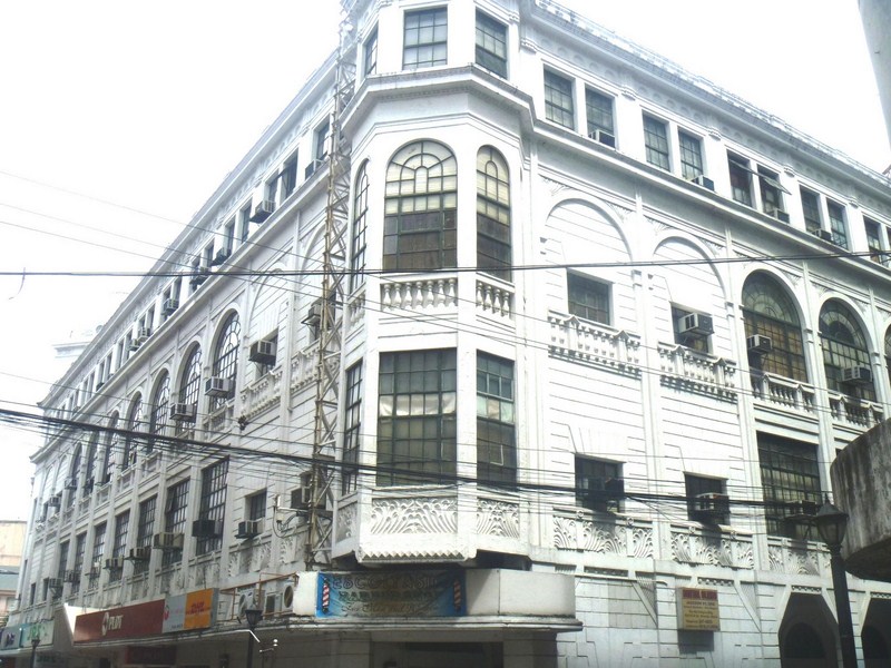
| Calvo Building |
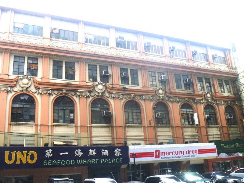
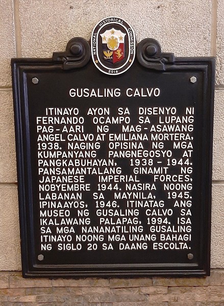
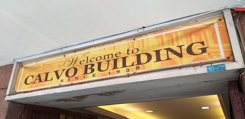
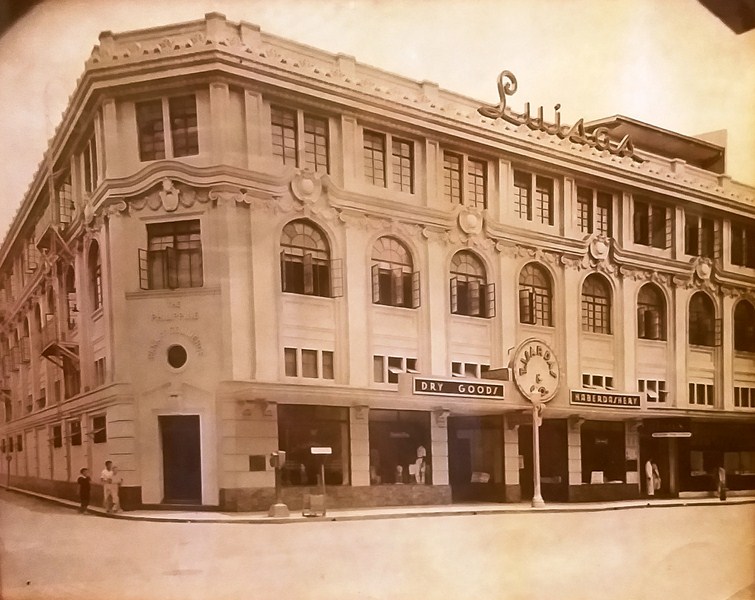
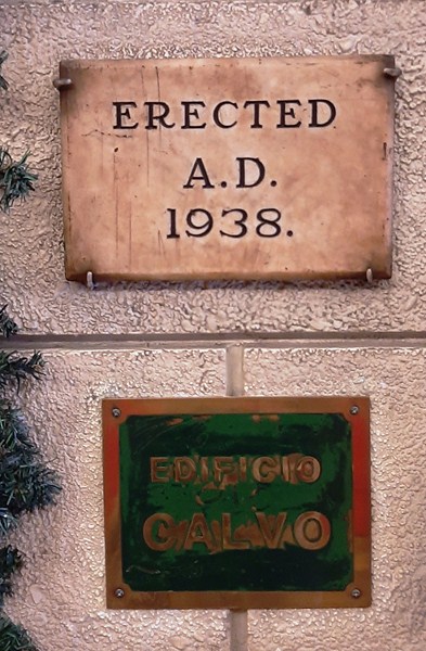
The stunning, Beaux Arts-style Calvo Building, built in 1938, was also designed by Arch. Fernando Ocampo. This 4-storey building, with its richly-decorated facade, once housed the Philippine Bank of Commerce, the popular MV Villar Records Store and the original radio station of Robert “Uncle Bob” Stewart’s Channel 7. On its roof deck was Luisa, a popular soda fountain. Today, Mercury Drug and Tropical Hut flank the entrance to the building, with Wah Yuen Hot Pot and Seafood Restaurant in its Calle Soda side. Its mezzanine is home to the little-known Escolta Museum.
Check out “Escolta Museum” and “Calvo Building“
Across the street from the Calvo Building is the decaying and dilapidated shell of the majestic, Mesopotanian-inspired Art Deco-style Capitol Theater. Built in the 1935, this theater, designed by National Artist Arch. Juan Nakpil, had a seating capacity of 800 and an unusual double balcony. Its lobby once mounted a beautiful wall mural by the late Filipino modernist and National Artist Victorio C. Edades. Now abandoned, it ceased operations in the late 1980s.
.JPG) |
| Capitol Theater |
On the face of its western tower were bas-reliefs, evocative of Art Deco lines and curves, showing Filipinas (one holding a mask and another holding a lyre) in traje de mestiza frame and set in a tropical landscape, attributed to the Italian atelier of Francesco Ricardo Monti. The bigger, 1600-pax Lyric Theater, another Art Deco masterpiece designed by Modernist Arch. Pablo S. Antonio, was demolished in the early 1980s.
Burke Building: 321 W. Burke St., cor, Escolta St., Binondo, Manila
Calvo Building: 266 Escolta St. cor. Calle Soda, Binondo, Manila. Tel: (632) 241-4762.
First United Building: 413 Escolta cor. David St., Binondo, Manila.
Natividad Building: Escolta cor. Tomas Pinpin St., Binondo Manila
Regina Building: W. Burke St., cor, Escolta St., Binondo, Manila
Roman S. Santos Building: Escolta cor. Yuchengco St., Binondo, Manila
.JPG)
.JPG)
.JPG)
.JPG)
.JPG)
.JPG)
.JPG)
.JPG)
.JPG)
.JPG)
.JPG)


.JPG)
.JPG)
.JPG)
.JPG)
.JPG)
.JPG)
.JPG)
.JPG)
.JPG)


