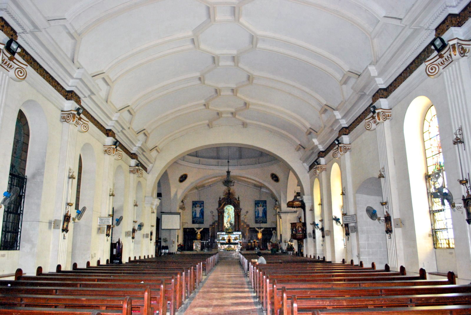
Sunset at Battery Grubbs (Corregidor Island)

Once settled in at the Corregidor Inn, Mark, Rico, Jovany (with Mat) and I took the opportunity to watch the sun go down at Battery Grubbs, one of the larger gun emplacements on the island.  We were driven to the west central part of the island, passing through a Spanish-style arch (above which is the name “Battery Grubbs) at the end of road’s end. The battery was named in honor of 1st Lt. Hayden Y. Grubbs of the 6th U.S. Infantry who died in 1899, during the Philippine-American War.

Check out “Hotel and Inn Review: Corregidor Inn

Arched entrance to Battery Grubb

Arched entrance to Battery Grubb

This gun emplacement, with two 10-inch guns (Model 1895M1) mounted on Model 1901 disappearing carriages  (Watervliet #25 / #14 and #22 / #16) intended to fire to the northwest, was originally emplaced in the Manila Harbor defenses.  It was built from November 1907 to early 1909 at a cost of a whopping (at that time) US$212,397.88. On February 2, 1911, it was transferred to Corregidor. These were apparently never changed during the service life of the battery.

Gun No. 1

Gun No. 1

This gun emplacement, with two 10-inch guns (Model 1895M1) mounted on Model 1901 disappearing carriages  (Watervliet #25 / #14 and #22 / #16) intended to fire to the northwest, was originally emplaced in the Manila Harbor defenses.  It was built from November 1907 to early 1909 at a cost of a whopping (at that time) US$212,397.88. On February 2, 1911, it was transferred to Corregidor. These were apparently never changed during the service life of the battery.

Gun No. 2

Gun No. 2

During the start of World War II, Battery Grubbs was not manned but, in early April 1942, Battery C of the 91st Coastal Artillery was transferred here from Battery Morrison  and the Number 2 gun was put into action.  The Number 1 gun, which had suffered some mechanical failure, was never commissioned. On April 11, an aerial bomb hit the power plant, putting the battery out of service. Five days later, a direct hit took out the number 2 gun and destroying the Battery Commander’s station.  The battery was subsequently abandoned.

The massive concrete parapets

The massive concrete parapets

After Corregidor’s surrender, the Japanese tried to restore the battery into a usable state but, before they could complete the work, it was heavily damaged during the U.S. bombardment in 1945. In 1994, the guns were repainted and railings installed for the visit of former U.S. Pres. Bill Clinton and his wife Hillary Clinton.

Sun Cruises, Inc. (SCI) – Reservation Office: CCP Terminal A, CCP Complex, Roxas Blvd., Manila.  Tel: (632) 831-8140 and (632) 834-6857 to 58.  Fax: (632) 834-1523.  E-mail: suncruises@magsaysay.com.ph.

Sun Cruises, Inc. (SCI) – Sales Office: 21/F,  Times Plaza Bldg., Ermita, Manila.  Tel: (632) 527-5555 local 4511 and 4512.  Fax: (632) 527-5555 local 4513.  E-mail: sales@suncruises.com.ph.

A Historical Tour of Corregidor (Cavite)

Battery Hearns

Come morning, prior to breakfast, Lee and Mark opted to do some fishing as South Dock.  The fish that early morning weren’t biting and the only thing they had to show for their unsuccessful effort was a lost fish hook.   After a hearty and filling breakfast, Mark and I, with other hotel and day tour guests, joined the regular tour via tranvia.  Its itinerary included Batteries Hearns, Geary, Way and Crockett, plus the Pacific War Memorial (and its museum), Lorcha Dock and the Spanish Lighthouse.

A tranvia

Battery Hearns, a 12-inch seacoast gun, was built from 1918 to 1921 at a cost of US$148,105. One of the last major additions to Corregidor’s defense system, it had a maximum range of 29,000 yards and was capable of firing in all directions. Intended to defend the island against enemy naval threat from the South China Sea, Battery Hearns had been in action firing towards Cavite from February 1942 and, on April 8 and 9, 1942, towards Bataan. When Corregidor fell, this gun emplacement was captured nearly intact by the Japanese.  It was subsequently repaired and put back into action.  However, in January and February of 1945, it was completely neutralized by American aerial bombardment.

Battery Way

Battery Way, built from 1904 to 1913 at a cost of US$112,969, was named after 2nd Lt. Henry N. Way of the 4th U.S. Artillery who was killed in 1900 during the Philippine-American War.  It was armed with four 12-inch mortars capable of firing a 1,000-lb. deck piercing of 700-lb. high explosive shell in any direction with a maximum range of 14,610 yards at the rate of one round per minute per mortar.  Three of the serviceable mortars opened fire on April 28, 1942 and on May 2, two of these were hit.  After more than 12 hours of continuous firing, the remaining mortar finally froze tight on May 6, the last to cease firing before the surrender.

Battery Geary

Battery Geary was built from 1907 to 1911 at a cost of US$145,198. It was named in honor of Capt. Woodbridge Geary of the 13th U.S. Infantry who died in 1899 during the Philippine-American War. With a maximum range of 14,610 yards, its eight 12-inch mortars were capable of firing in any direction.  Considered as the most effective anti-personnel weapon in Corregidor, the vertical plunging trajectories of the mortars made them ideal for use against enemy entrenched on higher grounds in Bataan.  The battery had two mortar pits with 3 magazines and its standard crew consisted of 4 men per mortar.

Battery Crockett

Battery Crockett, one of the 6″ disappearing” gun batteries that formed the interlocking field of fire which totally encircled the island, was built from 1905 to 1908 at a cost of US$290,049. Armed with two 12-inch seacoast guns mounted on disappearing carriages behind a concrete parapet, this battery basically fired south across the major southern channel into Manila Bay.  It had a range of 17,000 yards and was capable of a 170-degree traverse, with overlapping fields, or a total of 220 degrees coverage for the battery. Similar to Battery Cheney and Battery Wheeler in design, it was centrally located on the island.

Pacific War Memorial

The Pacific War Memorial, standing on the highest part of Corregidor, on the island’s west,  was built by the U.S. government and completed in 1948 at the cost of US$ 1,230,000.  It is dedicated to the Filipino and American soldiers who shed their blood on Corregidor. The memorial’s dome has an opening at the top through which sunlight shines through to exactly fill a circular altar on the week of May 6, the Fall of Corregidor. Left of the acacia tree-shaded entrance is the Cine Corregidor Ruins and behind it is a small, modest marble museum containing war relics, photos, a documentary film projection room, souvenir shop and descriptive information.

Eternal Flame

To the right of the museum is the remains of the Bachelor Officers’ Quarters and the Post Headquarters.  Within the complex is the steel wing-shaped sculpture Eternal Flame designed by Greek-American sculptor Archimedes Demetrius. The flagpole, originally a mast of a Spanish warship, was salvaged by Admiral George Dewey after the Battle of Manila Bay, and had it planted in Corregidor.  It is where the American flag was lowered during the surrender and raised again during the liberation.  The American flag was lowered for the last time on October 12, 1947 and the Philippine flag was hoisted in its stead.

Lorcha Dock

Lorcha Dock, situated near Gen. Douglas MacArthur Park (has a life-size bronze statue of the general), is often referred to as The Army Dock or MacArthur’s Dock.  It was at this dock where, on March 11, 1942, Gen. Douglas MacArthur boarded PT Boat 41, under the command of Navy Lt. John Bulkeley, for Australia.  The Spanish Lighthouse, located on the highest point of the island (628 ft. above sea level), is a reproduction of the old lighthouse built in 1897 but destroyed during World War II.  It has a commanding view of the island.  We previously visited the lighthouse and the Pacific War Memorial during the Adventour.

Mark tries out the ROCKet zipline

After the tour, we returned to the hotel for lunch and check out.  After lunch, all four of us, together with Jovy and Mat, proceeded to the Mile Long Barracks for additional photo ops and, prior to our leaving, Mark (a first for him) and I tried out the ROCKet Zipline (http://www.benjielayug.com/2009/12/launch-of-the-rocket-zipline-corregidor-cavite.html).  a 40-ft. high, 300-m. long free-fall cable ride.  Gravity-propelled and with rocket-like speed, it stretches from Corregidor Inn to the South Beach.  This piece de resistance truly capped two adrenalin-fulfilling days in the historic, and now adventure-filled, island of Corregidor.

Sun Cruises, Inc. (SCI) – Reservation Office: CCP Terminal A, CCP Complex, Roxas Blvd., Manila.  Tel: (632) 831-8140 and (632) 834-6857 to 58.  Fax: (632) 834-1523.  E-mail: suncruises@magsaysay.com.ph.

Sun Cruises, Inc. (SCI) – Sales Office: 21/F,  Times Plaza Bldg., Ermita, Manila.  Tel: (632) 527-5555 local 4511 and 4512.  Fax: (632) 527-5555 local 4513.  E-mail: sales@suncruises.com.ph.

The Kamistisuhan Houses of Malolos City (Bulacan)

From the basilica, we made a walking tour of the city’s Kamistisuhan Houses which are mostly located along Pariancillo St. These houses, built by landed Filipino-Chinese families, typify the intricate architectural design of Spanish buildings.  When Pres. Emilio Aguinaldo moved the seat of government to Malolos, he established the various cabinet offices at these houses. Some of these houses are still inhabited by the descendants of the original owners and in a good state of preservation.  Others have been demolished or have been converted to commercial establishments.

The beautifully restored Adriano-Vasquez Mansion, a perfect example of adaptive reuse, once housed Aguinaldo’s Gobierno Militar de la Plaza.  Now the Meralco Bldg. (Meralco bought it in 1995 and restored it in 1997), it has a filigreed cast iron staircase that wind up to the balustered rampart.

The Adriano House
 The 2-storey Bautista Caryatid House, behind the Adriano House, has ornately sculpted Neo-Classic touches and was built in 1855 and redecorated in 1877 in the French Art Noveau style.  It was the Secretaria de Fomento and home of Antonio Bautista, Aguinaldo’s Secretary of the Interior.  It contains heirloom memorabilia including the original KKK flag and here, Jose Rizal and Marcelo H. del Pilar spoke to the 21 women of Malolos on June 27, 1892.  Through the years, the house has been used as a municipal hall, a primary school and a barracks for Japanese soldiers.  Restored in the 1970s by descendant Basilidez “Dez” Bautista, its ground floor has an arched double door while the second floor’s columns are decorated by unique caryatids.
 
The Bautista Caryatid House 

The Erastro Cervantes House, beside an old movie theater, once housed Aguinaldo’s Department of the Interior.   The Arcadio Ejercito House housed Aguinaldo’s Department of War.  The Lino Reyes House, across the side entrance of the cathedral, once housed Aguinaldo’s Secretaria de Exterior.  Built by couple Lino and Maria Reyes probably after they were married in 1892, it was progressively renovated in the 1930s.  The house has an octagonal rose window and a weather vane on top of the roof.  

A sad case in point is the Ponciano Tiongson House which was demolished in the 1980s.  Formerly located across the Erastro Cervantes House, it had intricate balustered windows and once served as Aguinaldo’s Commisaria de Guerra.  An internet cafe now stands in its place.

The Hermogenes Reyes House

Other ancestral houses were built during the early American era.  The Hermogenes Reyes House, located a few blocks from the cathedral, was built in 1904 by couple Hermogenes and Teodora Reyes.

The gabled roof Lomotan House
The Dr. Luis Santos House, built in 1933 by an EENT doctor, has a spacious front garden with a fountain with a pair of lovely nymphs. The house sports a pastel blue and white, Art-Deco-inspired facade.

Dr. Luis Santos House

Adriano-Vasquez Mansion: Pariancillo St., Malolos City, Bulacan.
Arcadio Ejercito House: cor. Estrella and Pariancillo Sts., Malolos City, Bulacan.
Bautista Caryatid House: Sto. Nino St., Malolos City, Bulacan
Erastro Cervantes House: Pariancillo St.,Malolos City, Bulacan.
Hermogenes Reyes House: F.T. Reyes St. (formerly Calle Electricidad), Brgy. Sto. Nino, Malolos City, Bulacan.
Lino Reyes House: Estrella St., Malolos City, Bulacan.
Lomotan House: Sto. Nino St., Malolos City, Bulacan

Minor Basilica of Our Lady of the Immaculate Conception (Malolos City, Bulacan)

After our Barasoain Church visit, Jandy and I proceeded on our way to the nearby Minor Basilica of Our Lady of the Immaculate Conception, the ecclesiastical seat of the Diocese of Malolos.  Located in front of the city hall, this Neo-Classical church, and its convent, were first built with light materials in 1591, rebuilt and enlarged in 1691 by Fr.  Roque Barrionuevo, rebuilt with stronger materials in 1734 by Fr. Fernando Sanchez and completed in 1740 by Fr. Juan de Meseguer. Fr. Jose de Vivar did minor restorations in 1753.  Both were destroyed by fire in 1813. From 1963, several restorations were pursued by Engr. Alfredo Aldaba, affecting the facade, dome, transept and main altar.  The present church was started in 1819 by Fr. Melchor Fernandez and consecrated on October 14, 1826.  Severely damaged during the June 3, 1863 earthquake, it was restored from 1859 to 1872 by Fr. Ezekiel Moreno.

Minor Basilica of Our Lady of the Immaculate Conception

The convent was damaged during the July 19, 1880 earthquake, restored in 1883 by Fr. Juan M. Tombo and completed in 1884 by Fr. Felipe Garcia. It was the official residence (Palacio Presidential) of Pres. Emilio Aguinaldo from September 10, 1898 to March 29, 1899.  The convent was reconstructed in 1975.  In 1976, both church and convent were blessed  by Rev. Bruno Torpigliani, the Apostolic Nuncio to the Philippines.

The convent

The basilica has a moderately-decorated, symmetrical facade divided into 3 segments by superpositioned Doric columns and dominated by large, semicircular arched openings on the first level.  The triangular pediment, decorated by a stylized Augustinian emblem at the center, is topped by acroteria and torch-like finials.  The horizontal Doric frieze is decorated with triglyphs and the fluted pilaster-flanked, statued niche is topped by a segmented canopy crowning the tilted frame of the center window.

The basilica’s interior

The basilica has a slender, 4-storey bell tower on its right.  It used to have a triangular cone which was replaced, during the basilica’s renovation in 1970, by a concrete statue of the Immaculate Conception (donated by Amparo Bautista).

The Kalayaan Tree

In front of the basilica (at the right side of the plaza) is a 12-m. high siar tree (Peltophorum pterocarpum), now known as the Kalayaan Tree.  It was said to have been planted by Gen. Aguinaldo during a lull in the convention. proceedings.  Under this tree is a monument depicting a meeting of Filipino revolutionaries Gregorio del PilarIsidoro Torres, Don Pablo Tecson, Fr. Mariano Sevilla and Dona Basilia Tantoco.

The monument under the Kalayaan Tree

Barasoain Church (Malolos City, Bulacan)

After breakfast and swimming at DJ Paradise Resort & Hotel, Jandy and I checked out of our room, boarded our Toyota Revo and proceeded to the city proper where we plan to visit Malolos’ historical sights.  The first item in our agenda was, fittingly, the Barasoain Church (also called the Church of Our Lady of Carmel), the site of the Revolutionary Congress which ratified independence, framed the Malolos Constitution and inaugurated the short-lived First Philippine Republic (Malolos Republic). Former president Joseph E. Estrada also took his oath of office here.

Barasoain Church

This noble and dignified church, with its beautiful concerto of rhythmic layers, has a Neo-Classical facade with a recessed main entrance with concentric arches (a Romanesque feature) flanked by two smaller doors, fluted  flat pilasters (a Renaissance feature), a Baroque segmental pediment,  and sharp line moldings at the cornice, base and top of the piers.  The two sides of the facade, with its sweeping concave lines at the upper wall, curve inward to form an oval shape.

The altar frontal
The church interior
The church pulpit

Inside is a unique 18th century altar frontal with beautiful stone columns and murals on the walls and ceilings done by Baliwag artists and the National Historical Institute.  The church is now airconditioned during Sunday mass.

The bell tower

The 4-storey, octagonal bell tower on the left, was built in 1889 by Fr. Martin Arconada and is crowned by a conical roof.  It has 3 bells installed in 1897 and has alternating open and false windows rising in uneven modules that end up in the crenellated base of the pointed pinnacle.

Barasoain Convent

Beside the church is the convent.  First built in 1859 by Fr. Francisco Arriola, it was restored in 1889 by Fr. Martin Arconada and in 1894 by Fr. Miguel de Vera.  During the short-lived Philippine Republic, it was again restored by Arcadio Arellano and used as the Universidad Cientifica y Literaria de Filipinas.  It now houses two museums: the Ecclesiastical Museum and the Barasoain Museum.   Both church and convent were declared as National Landmarks on August 1, 1973 and on January 23, 1999.

Carriage used by Pres. Aguinaldo during his inauguration
The convent courtyard
Barasoain Church: Paseo de Congreso, Malolos City, Bulacan.  Tel: (044) 662-7686.

The Forbidden City – Inner Court (Beijing, People’s Republic of China)

The Inner Court is composed of the 3 main structures at the rear of the Forbidden City, all official residences of the Emperor and Empress and all smaller than the Outer Court halls, namely the Palace of Heavenly Purity (Qianqinggong), the Hall of Union (Jiaotaidian) and the Palace of Earthly Tranquility (Kunninggong).

Palace of Heavenly Purity

The first structure inside the inner court is the  Palace of Heavenly Purity, the largest of the 3 halls. During the Ming Dynasty, it was the residence (the large space was divided into 9 rooms on 2 levels, with 27 beds) of the Emperor and, during the Qing Dynasty, the palace often served as the Emperor’s audience hall, where he held council with the Grand Council, received ministers and emissaries, and held banquets. This double-eaved building, connected to the Gate of Heavenly Purity to its south by a raised walkway, is set on a single-level white marble platform.  At the center of the palace, set atop an elaborate platform, is a throne and a desk, on which the Emperor wrote notes and signed documents during councils with ministers. A caisson is set into the roof, featuring a coiled dragon.

Behind it is the  Hall of Union. Square in shape and with a pyramidal roof, the 25 Imperial seals of the Qing Dynasty, as well as other ceremonial items, were stored here. The third hall is the Palace of Earthly Tranquility, the emperors’ wedding room. This double-eaved building is 9 bays wide and 3 bays deep.

Exhibit Hall of Textiles and Apparel

Besides the 3 main buildings are the 6 eastern palaces and 6 western palaces, where the emperor used to handle everyday affairs, and which was the living quarters of the emperor, empresses and concubines. Those palaces have been converted into exhibition halls, where a spectacular set of imperial collections is displayed. The Exhibit Hall of Textiles and Apparel, reflecting the nomadic heritage of the rulers, showcases stately court robes plus the emperor’s accouterments.

Imperial Garden

Behind these 3 halls lies the relatively small and compact 1,2,000 sq. m. Imperial Garden (Yu HuaYuan), he private garden of the imperial family (used exclusively by the imperial family to sip tea, play chess, meditate and generally relax) and the last part of the Forbidden City. The garden was built in 1417 during the Ming Dynasty. The most typical imperial garden in China, it is an aesthetic change from the crimson and gray building complex to a colorful and luxuriant atmosphere. The garden contains several elaborate landscaping features.

Hall of Imperial Peace

Within the garden, there are about 20 structures in different styles. It is interesting how the manmade structures maintain harmony with trees, rockeries, flowerbeds and bronze incense burners in this relatively small space.  The Hall of Imperial Peace (Qin’AnDian), first built in the 15th century, is the main structure in the Imperial Garden and the only one on the central axis – it stands in the center of the garden, encircled by a rectangular wall.  In each of the four corners of the Imperial Garden there is a pavilion, symbolizing the four seasons. The Pavilion of Myriad Springs is the most famous and lies in the south east corner of the garden. It was built in 1535 and restored during the Qing Dynasty.

Pavilion of Myriad Springs

To the north of the garden is the Gate of Divine Might, the north gate of the palace (we exited here). On the left side of the Inner Court is the Mental Cultivation Hall (Yangxindian), the most important building except for the Hall of Supreme Harmony. From the time of the third emperor, Yongzhen, all the Qing emperors, 8 in total resided in this hall.

The Forbidden City – Outer Court (Beijing, People’s Republic of China)

Upon entering the Meridian Gate, we were ushered into a large square pierced by the meandering Inner Golden Water River, which is crossed by 5 bridges. Beyond the square stands the Gate of Supreme Harmony, behind which is the Hall of Supreme Harmony Square.

Gate of Supreme Harmony

A 3-tiered white marble terrace rises from this square. Three halls stand on top of this terrace, the focus of the palace complex. From the south, these are are the Hall of Supreme Harmony (Taihedian, the largest), the Hall of Central Harmony (Zhonghedian) and the Hall of Preserving Harmony (Baohedian).

Hall of Supreme Harmony

The first hall we visited was the Hall of Supreme Harmony which rises some 30 m. (98 ft.) above the level of the surrounding square. It is the ceremonial center of imperial power, and the largest surviving wooden structure in China. It is 9 bays wide and 5 bays deep (the numbers 9 and 5 are symbolically connected to the majesty of the Emperor).  Set into the ceiling at the center of the hall is the Dragon Throne (Longyi), an intricate caisson decorated with a coiled dragon, from the mouth of which issues a chandelier-like set of metal balls, called the “Xuanyuan Mirror.” During the Ming Dynasty, the Emperor held court here to discuss affairs of state. During the Qing Dynasty, as Emperors held court far more frequently, a less ceremonious location was used instead, and the Hall of Supreme Harmony was only used for ceremonial purposes, such as coronations, investitures and imperial weddings.

Hall of Central Harmony

The Hall of Central Harmony is a smaller, square hall, used by the Emperor to prepare and rest before and during grand events. Behind it, the Hall of Preserved Harmony, was used for rehearsing ceremonies, banquets and was also the site of the final stage of the Imperial examination.  All 3 halls feature imperial thrones, the largest and most elaborate one being that in the Hall of Supreme Harmony.

Hall of Preserved Harmony

At the center of the ramps leading up to the terraces from the northern and southern sides are ceremonial ramps, part of the Imperial Way, featuring elaborate and symbolic bas-relief carvings. The northern ramp, behind the Hall of Preserving Harmony, is carved from a single piece of stone 16.57 m. (54.4 ft.) long, 3.07 m. (10.1 ft.) wide and 1.7 m. (5.6 ft.) thick. It weighs some 200 tons and is the largest such carving in China.

Northern Ramp

The southern ramp, in front of the Hall of Supreme Harmony, is even longer, but is made from 2 stone slabs joined together – the joint was ingeniously hidden using overlapping bas-relief carvings, and was only discovered when weathering widened the gap in the 20th century.

Hall of Literary Glory

In the south west and south east of the Outer Court are the Halls of Military Eminence (Wuyingdian) and Literary Glory (Wenhuadian). The former was used at various times for the Emperor to receive ministers and hold court, and later housed the Palace’s own printing house. The latter was used for ceremonial lectures by highly regarded Confucian scholars, and later became the office of the Grand Secretariat. A copy of the Siku Quanshu was stored there. To the northeast are the Southern Three Places which was the residence of the Crown Prince.

Upon exiting the Hall of the Preserving Harmony, we notices a huge block of marble carved with cloud and dragon designs. Past that, we entered  another gate called the Gate of Heavenly Peace (Qianqingmen), the main gateway to the Inner Court.

The Forbidden City (Beijing, People’s Republic of China)

After about half an hour of photo ops at Tiananmen Square, it was now time for us to enter the Forbidden City (also officially known as the Imperial Palace Museum), the best preserved imperial palace in Beijing  and the largest surviving ancient palatial structure in the world.  With Brittany, our guide, taking the lead, we all crossed Dongchangan St. and entered the city via Tiananmen Gate (Gate of Heavenly Peace) where most tourists enter.  The gate has a huge portrait of Chairman Mao Zedong, widely used as a national symbol.   Our tour of the Forbidden City would take about 2 hours.

Tiananmen Gate

The 72-hectare (178-acre) Forbidden City, the seat of Imperial power for 500 years, was commissioned by Emperor Yong Le, the third Emperor of the Ming Dynasty,  and was built between 1406 and 1420.  It was home to 24 emperors of the Ming (1368–1644) and Qing (1644–1911) Dynasties.  However, it  was burnt down, rebuilt, sacked and renovated countless of times, so much so that most of the splendid architecture we saw today dates from the 1700’s onwards.  In 1961, the Forbidden City was listed as one of the important historical monuments under the special preservation by the Chinese central government and, in 1987, it was nominated as a World Cultural Heritage by UNESCO. This treasure house of Chinese cultural and historical relics is recognized as one of the most important 5 palaces in the world (the other 4 being the Palace of Versailles in France, Buckingham Palace in the U.K., the White House in the U.S. and the Kremlin in Russia).

Outer Court

The complex was so huge so it took us quite a while to walk through, especially when we  wanted to have a close look at everything. Its dimensions are huge, being 961 m. (3,153 ft.) from north to south and 753 m. (2,470 ft.) from east to west and is surrounded by a 7.9-m. (26  ft.) high city wall and a 6 m. (20- ft.) deep by 52 m. (171 ft.) wide moat. The walls are 8.62 m. (28.3 ft.) wide at the base, tapering to 6.66 m. (21.9 ft.) at the top. Altogether, it has a total floor area of approximately 150,000 sq. m. (1,600,000 sq. ft.) and consists of 90 palaces and courtyards, 980 buildings and 9,999 bays of rooms, not all of which can be visited.

Inner Court

Traditionally, the Forbidden City is divided into two parts: the Outer Court (or Front Court) and the Inner Court (or Back Palace).  The Outer Court, used for ceremonial purposes, includes the southern sections.  The Inner Court, the residence of the Emperor and his family, was used for day-to-day affairs of state and includes the northern sections. Generally, the Forbidden City has 3 vertical axes with the most important buildings are situated on the central north-south axis.

Meridian Gate

Once past Tiananmen Gate, we crossed an expansive brick-paved square until we reached the 5-arched Meridian Gate (Wumen), the largest gate and the main entrance to the palace. The gate was the place where the Emperor announced the new lunar calendar on the winter solstice.  Once through Meridian Gate, we go across Golden Stream Bridge and on to the Outer Court.

Forbidden City: No.4 Jingshan Front Street, Dongcheng District 65132255, Beijing, People’s Republic of China.  Open 8:30 AM-5 M. Admission: RMB60

Tiananmen Square (Beijing, People’s Republic of China)

From the National Centre for the Performing Arts, Tiananmen Square was just a short leisurely walk.  This 440,000 sq. m., 880 m. by 500 m. city square, the largest  in the world (it can accommodate 600,000 people), lies between 2 ancient, massive gates: the Tian’anmen Gate (after whom the square was named) to the north (it separates it from the Forbidden City) and the Zhengyangmen, (better known as Qianmen) Gate to the south.  Designed and built in 1651, the square has since been enlarged 4 times its original size in the 1950s.

Tiananmen Square

The square has great cultural significance as it was the site of several key events in Chinese history such as the May Fourth Movement (1919); the proclamation of the People’ Republic of China by Mao Zedong (October 1, 1949); the annual mass military displays on all subsequent National Days until October 1, 1959; the military parades for the 35th (1984), 50th (1999) and 60th (2009) anniversaries of the People’s Republic of China, and the Tiananmen Protests in 1976 (after the death of premier Zhou Enlai) and 1989.

National Museum of China

The square is flanked by the National Museum of China (dedicated to Chinese history predating 1919) on the east and the Great Hall of the People on the west.   On the main north-south axis of the square is the Mao Zedong Mausoleum, built near the site of the former Gate of China (demolished in the 1950s) upon Mao’s death in 1976.

Monument to the People’s Heroes

On its southern edge is the 38 m. (125-ft.) high Monument to the People’s Heroes, built in memory of the martyrs who laid down their lives for the revolutionary struggles of the Chinese people during the 19th and 20th centuries. The monument, constructed from August 1952 to May 1958, was designed by Architect Liang Sicheng, with some elements designed by his wife, Lin Huiyin.  The monument weighs over 10,000 metric tons and contains about 17,000 pieces of marble and granite from Qingdao, Shandong Province and Fangshan District outside Beijing.

Tiananmen Square is open, with no trees or benches.  However, trees line its east and west edges. The square is lit with large lampposts which are fitted with video cameras.

Great Hall of the People

Tiananmen Square and 6 other places in Beijing were selected  as “red tourist” sites by the State Tourism Administration as part of a “red tourism” program aimed at boosting tourism in former revolutionary bases. Being a regular tourist destination, the square was filled with tourists and the occasional columns of precision-marching soldiers in their familiar green uniforms.

A Column of Precision-Marching Soldiers

War Memorial Museum (Lingayen, Pangasinan)

War Memorial Museum

War Memorial Museum

This open-air museum, within the Lingayen Gulf War Memorial at the Provincial Capitol Compound, has relics of the American landing during World War II. On December 22, 1941, during World War IIJapanese Gen. Masaharu Homma and his 43,000 troops landed at Lingayen Gulf. Four years later, on January 9, 1945, Gen. Douglas MacArthur also landed here with 68,000 American troops during the liberation.  A stone marker here marks the landing site.

The exhibits

The exhibits

The open-air exhibits include a twin 40 millimeter ant-aircraft gun, a naval 3” gun, a Japanese Nakajima “Kate” torpedo bomber and two repainted U.S. M24 “Chaffee” tanks (one has its turret turned to the side, and the other’s turret is to the front).

A repainted U.S. M10 tank

A repainted U.S. M24 “Chaffee” tank

Japanese Nakajima “Kate” torpedo bomber

Japanese Nakajima “Kate” torpedo bomber

The author, Cheska and Jandy beside an ant-aircraft gun

The author, Cheska and Jandy beside a twin 44 mm. anti-aircraft gun

A pagoda displays a collection of historic photographs (including information on HMAS Australia hit by Kamikazes) while a bronze compass and map, in the center of the compound, details the US Army units that landed on January 9, 1945 at Lingayen Gulf.