Picnic at Digyo Island, Cuatro Islas (Inopacan, Leyte)

On our last whole day stay in Leyte, Jandy and I were invited by Mr. Roy Perez, a medical representative of Astra Zeneca who toured us around Ormoc City, to join him and his family and relatives on a picnic tour of the Cuatro Islas.  We were picked up by Roy after breakfast and, in his car, we traveled the 107-km. distance to Baybay in about 2 hrs.. At the town’s port, we boarded, together with the others, a large outrigger boat rented for our use.
  
On our way to Digyo Island

As the name implies, the Cuatro Islas consists of 4 lovely islands; Apid, Digyo, Himokilan and Mahaba, all of which are bordered by white sand beaches, rich fishing ground and unexplored coral reefs (a total of 287 species).   Though Baybay was our jump-off point, three of the four islands (Apid, Digyo and Mahaba) belong to the town of Inopacan while Himokilan Island is under the jurisdiction of Hindang.
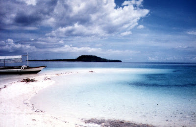
Digyo Island’s beautiful sandbar.  Across is Himokilan Island

Digyo (pronounced as Dijo) Island, our destination, is the smallest,  prettiest and most popular tourist destination of the four.  After 30 mins., our outrigger boat made landfall at the island’s beautiful sandbar of fine, white sand. Good coral growth, ideal for snorkeling, are located at the western part of the island, facing Apid Island. The island is also a nesting site of sea turtles.  While there, I circled the island in about 20 mins.

Digyo’s white sand beach
Big, delicious coconut-cracking crabs called tatus are found in Himokilan Island, the largest of the four islands. Mahaba Island, serviced by outrigger boats, has a viewing deck, kiosks, sari-saristores and restrooms.  Diving and snorkeling equipment, as well as barutos(stiletto-shaped dugout canoes) and glass-bottom boats, can be rented here.

Marabut Marine Park (Marabut, Western Samar)

The resort’s beach and catamaran

On April 20, Holy Thursday, I decided to visit to Marabut Marine Park and Beach Resort in Marabut with my brother-in-law Manny and my son Jandy.  Marabut is the last town before the border with Eastern Samar, off the southern coast of Samar.  However, Manny’s car was trapped in the garage due street diggings along the street.  Mr. Victor Macasera, my Astra medical representative guide to Sohoton Caves, came to our rescue by offering to bring us there.  After our usual early morning breakfast and loaded with our usual picnic basket prepared by Paula, manny’s wife, we departed Tacloban City around 9 AM, crossed the San Juanico Bridge to Samar, turned right at the fork to Basey and proceeded, down a well-maintained road, to Marabut town.

Burial cave

Soon, we espied the beautiful stack of small limestone islands of the marine park just off the horizon.  Near the resort, we made a stopover at a small cave along the highway.  Inside, we saw a cross, an image of the Blessed Virgin and a net-covered concrete vault containing the mixed up bones of victims killed by the Japanese during World War II.  About a kilometer past the cave, we came upon the road sign and an  700-800 m. long access road leading to the resort.  Past an old, wooden loggers’ lodge was the entrance to the resort.  We parked our car and rented a picnic shed for our use.

The islands of the marine park

This 1-hectare resort, opened in 1997, sits on a 90-hectare land planted with rice and coconut trees.  It also has a reforestation area planted with mahogany and gmelina trees. The resort is owned by the Unimaster Conglomeration, Inc. of Mr. Wilson Chan, the same corporation that owns the Leyte Park Hotel in Tacloban City.  It has 5 nipa, bamboo and wood duplex cottages with bath, an open-air restaurant and a bar.  Being a holiday, the resort was full of Filipino-Chinese guests brought over from Leyte Park Hotel via a huge double-hulled catamaran moored along the beige sand beach.  Beyond that were the 15 dramatic limestone islands that constitute the marine park, all leased from the local government for the exclusive use of the resort.  Although filled with guests, the beach was surprisingly empty of swimmers.

All geared up and ready to go

As we were going around the resort, we came across a group of tourists milling around a dazed man pockmarked with red sores from head to foot.  He was just bitten by a jellyfish while swimming along the beach and was being administered with antibiotics.  It was jellyfish season. No wonder the beach was empty.  So much for the swimming.   Still the limestone islands beckoned.  As we were preparing the table and ourselves for lunch, I espied a number of brave sea kayakers heading towards the islands.  I immediately made a reservation for a 2-pax, sit-on sea kayak.  If I can’t swim along the beach, I could at least kayak.  The resort has 8 plastic kayaks – 3 single and 5 double; plus one outboard motor boat.   Kayak rental is PhP75 per hour, inclusive of life vests but with no helmets.

However, I was placed on a waiting list.  There was nothing to do at the moment except eat, and eat we did.  With food enough for double our party, we feasted on tipay (scallops baked in garlic), kilawinpansit canton, grilled tilapia and steamed rice, all washed down with bottled water or canned soft drinks.  We were too full to even touch the ripe mangoes for dessert. Pretty soon, the previous kayakers returned and as soon as the kayaks were parked, I immediately laid my claim to a kayak. Jandy and I quickly applied sun block lotion, packed our snorkels and camera in a dry plastic bag, donned our shades, rubber slippers and life jackets and were soon on our kayak.

Sea kayaking wasn’t a breeze as I first thought it would be.  Jandy was seated up front and it took some time for us novices to coordinate our paddling and maneuvering efforts.  For a time we seemed to be going nowhere, but soon we got the hang of our double oars and were soon on our way in a leisurely, exploratory pace.  Still wary of going very far, I decided first to visit some of the mainland’s inaccessible and scenic hidden coves just around the beach.  Going there only seemed to bring the islands closer to me and, with a little guts and a prayer, were soon paddling full speed ahead.

The nearest was a magnificent 3-peak island with a white sand beach tucked in between them.  Shooting straight up from the sea like natural skyscrapers, the islands’ towering limestone cliffs’ base were heavily undercut by wave action and were topped by dense jungle.  This scenery reminded me of similar islands (although more compact and much nearer) seen as I toured the equally beautiful Dimakya Island (Club Paradise, Coron in Palawan) and Gigantes Islands of Iloilo.

Pretty soon, after about 20 mins. of paddling, its white sand beach hove into view as the surrounding waters became clearer.  We had to maneuver around to avoid some large rocks visible under the water and soon hit dry land.  We were the only visitors there and we both felt like Robinson Crusoe (or is it Swiss Family Robinson?).  We donned our snorkels and explored its clear waters and coral garden of staghorn and brain coral.  No jellyfish in sight. Thank God.  This condition was soon broken by the arrival of 3 other kayaks from the resort, all paddled by Filipino-Chinese guests of the resort.  We gladly lent our snorkels (and rubber slippers) to the group.

I had my eye on visiting the next island’s white sand beach, and seeing a golden opportunity, suggested a joint kayaking safari with our new friends to the island.   Our next destination was similar to the first except that its peaks were not as rounded.  We reached it after 15 mins., but we were not the first arrivals as a large outrigger pumpboat loaded with tourists was already there even before we left the first island.  Snorkeling here was quite a disappointment and the only floating creature I espied was a jellyfish!  We quickly made a dash for the shore.  Instead, I tried to go around the islands’ heavily undercut girt but soon gave it up upon reaching waist-deep water.

From the island we could espy the third island’s white sand beach (only 3 of the 15 islands have white sand beaches).  In the distant horizon was the all too familiar Tooth Island, a bizarre, hourglass-shaped limestone outcrop (no beach) featured in a colored postcard.  My spirit was willing but I was already tired.  I decided to abandon the idea and instead started paddling, together with the others, back towards the mainland.  Although tired, our strokes were more fluid, just like professional kayakers.  After about 30 mins. we were back at the resort, having been gone for 2 hrs., dead tired and with aching muscles.

Jandy and I turned over our kayaks and life vests to Manny and Victor and they were soon kayaking to the nearest island.  While they were away, I decided to interview Mr. Angel Quiminales, the resort manager.  Angel gave me an overview of the resort’s beginnings, facilities and future plans including a future saltwater swimming pool and additional cottages. My heart sank when Angel told me of a hidden lagoon located just 400 m. from, and to the right, of the mainland beach.  It sank even deeper when he told me that the second island I visited had a beautiful cave with beautiful stalactites just around the beach.  It was a frequent destination for foreigners.  If only I knew.  After this 45-min. interview, we decided to call it a day, thanked Angel and paid our bills (picnic shed and kayak use).  We left Marabut by 4 PM and were back in Tacloban by 5 PM.  The next day, being Good Friday, I decided to rest.

Calbiga Caves System (Western Samar)

I have heard a lot about this relatively unknown, 900 sq. km. Calbiga Cave System in Western Samar, said to be the largest cave system in Asia, and Jandy and I opted to do some cave exploring there. Jandy and I woke up early, had a hearty breakfast, brought my camera, videocam, flashlight, spare batteries and a pack lunch (prepared by my sister-in-law, Paula) of corned beef sandwiches and bottled water, donned our media jackets (with its many convenient pockets) and proceeded, by jeepney, to the Tacloban City bus terminal by the pier.

The low cave entrance

We made the 59-km. (1 hr.) trip from the city to Calbiga via the 7:30 AM regular bus to Catbalogan, passing the same deplorable road conditions we encountered the day before. Upon our arrival at the town, we immediately registered our names at the municipal hall so that a mayor’s permit could be processed and secured.  A group of 9 had registered even earlier, having been in town since 7 AM.  Before we were issued permits, Municipal Administrator Mr. Mario Cabujat gave us a short talk on the past history of the caves and the dos & dont’s in exploring the cave.  After the briefing, we were all given our respective mayor’s permits.   The other group was kind enough to let us hitch with them in their AUV.

The initial 4-km. road going to Brgy. Panayuran was concrete-paved  up to a kilometer, becoming rough the remaining distance.  Our AUV arrived at the jump-off point by 10 PM and parked our vehicle.  We then negotiated with the residents for some guides and working Petromax lamps, settling on PhP250 per guide and PhP50 per Petromax lamp.  I got one guide and lamp while the others got another lamp and guide.  For additional lighting, some brought along some “Molotov cocktails” (actually kerosene-filled bottles with lighted rags as wicks).

A phallus-like stalagmite

Soon after, our group, now enlarged to 14 (another resident tagged along), started our trek along a well-marked trail passing through tall, 10-ft. high cogon grass.  Midway, the trek became steep and rocky as we entered a light forest.  We made a number of rest stops and the trail became narrower as we neared the cave. After an hour’s hike, we reached the dark, low cave opening, located below a limestone cliff studded with weathered stalactites. Going down from the main entrance (there are actually 5) was easy but going about this cave was a struggle as one had to hop from one rock to another with hardly any flat area.  Deciding on which rock to step on wasn’t easy as a lot were sharp and some were loose.  The cave floor was also littered with detached stalactites from previous illegal mining operations.  Some passageways were also narrow and low and one has to watch his (or her) head negotiating these areas.

Vakul

The first chamber, 5-km. long, 40-m. wide  Langun Cave, was huge.  Our flashlights could barely penetrate the darkness, much less reach the over 50-m. high ceiling.  Surprisingly, bats do not inhabit the caves.  The only flying things about are swallows (balinsasayaw).  We rested by a beautiful calcite formation with a small, clear reservoir of mineral water and refilled our water bottles and ate our packed corned beef sandwiches here, sharing some with the two guides.  Water was occasionally dripping from the ceiling, reminding me that it was seeping water that hollowed out these caves by dissolving the limestone and combining to precipitate  calcite over millions of years.  Also, the evaporation of water in places, leaves minute deposits of calcium carbonate that hang hollowly from the cave’s roof (stalactites) or rise solidly and more stumpily from the floor (stalagmites).  It is said that it takes a hundred years to make 1 cm. of pure white stalactite or stalagmite.

“Lady with the Lamp”

After our half-hour lunch, we resumed our exploration, taking my camera and videocam but leaving behind my backpack with my rubbish inside.  Every now and then we would come across beautiful, stalagmites of glittering snow-white calcium carbonate crystal, without a trace of other minerals, carved and combined to form beautiful shapes.  Unlike Sohoton Caves, none of them have yet been named. I therefore dubbed one with helictites (an occasional twisted, twiglike growth) as “The Lady with the Lamp” (in honor of Florence Nightingale, God bless her soul!), a beautiful, bullet-like,  snow-white stalagmite I dubbed as “The White Phallus” (I could think of no other description), another I dubbed  “The Inverted Shoe” (or bakya) and a huge calcite waterfall imbedded with tiny calcite crystals which glittered when lighted by our lamps, I dubbed as “Vakul,” because it reminded me of the Batanes headwear worn by Ivatan women.

“Casper the Friendly Ghost”

Our entry into 270 m. long, 160 m. wide Gobingob Hall, the second chamber, was no less easy and quite unglamorous.  We had to pass through a floor of soft and moist muck.  Our shoes sunk with every step and efforts to raise them was an ordeal.  Oftentimes they remained stuck in the mud.  One member of our party broke her slipper while others just took them off and walked barefoot.  After what seemed an eternity, we were ushered into a huge cathedral-like chamber with huge stalactites hanging from the ceiling. Unlike the previous chamber, the floor here was level, albeit muddy, with long-legged crickets, faded to a pale and sickly hue, hopping around. Inside, too, was an underground stream.  Italian spelunkers have found blind cavefish (the first in the country), crabs and other small shellfish here, true troglodytes wholly adapted to sightless existence in caves.  Try as I must, even with my flashlight, I could not espy a blind cave fish in the still waters.  Other members of the party were able to see one.  I was, however, able to observe, up close, a colorless blind crab caught by one of the group.  It was later released, unharmed.

“The Inverted Shoe”

Our visit to this chamber ended our cave tour. We retraced our steps back to where we left our backpack, proceeded on the cave entrance and emerged, dead tired, at 2:30 PM after 3 hrs. of exploration.  The thought of hiking the 3-km. uphill/downhill trail back to the village daunted me and after a few minutes hike, I asked my guide to carry my backpack the rest of the way.  We reached the village by 4 PM. After washing up, paying the guides (I paid my guide an extra PhP50 for carrying my backpack) and signing the required guestbook, we left the village at 4:30 PM for the trip back to Tacloban.  After 2 or 3 stops due to overheating plus a detour to Basey to drop off some passengers, we reached Tacloban by 8 PM.

The Calbiga River (Western Samar)

After lunch, Jandy and I took a jeepney to the Tacloban Bus Terminal, near the port, to get a Catbalogan-bound bus to Calbiga in the hope that we could still do some spelunking at Calbiga Caves.  The 59-km. bus trip took all of 1 hr., crossing the San Juanico Bridge, and on to the Maharlika Highway, passing the towns of Basey, Sta. Rita, Villareal and Pinabacdao before reaching Calbiga. Travel time would have been shorter where it not for the deplorable road conditions, with potholes everywhere and, in some places, half of the road had all but disappeared, creating one-way portions.  In Brgy. Lagayan, an alternate route has to be cleared to replace an irreparable portion of the highway.  Upon arrival at the town, we were informed at the municipal hall  that it was too late in the day to visit the caves.  Instead, we just had to console ourselves with a boat trip to Calbiga River’s Carewos Rapids.

Carewos Rapids

The 18-km. long and 10-m. deep Calbiga River, with some 60 challenging rapids, is reputed to be the country’s only navigable wild river suitable for white water rafting.  Docking near the rapids, we tried swimming but this was actually difficult as we had to battle the rapids.  A rope was thrown across both banks  of the river as a lifeline in case we do get swept away.

According to the International Scale of River Difficulty, these rapids are classified as Class III or Class IV, depending on weather conditions.   The river has long rapids with high waves and a lot of irregular rocks.  The Calbiga River requires mandatory scouting, a good quality boat (a smaller boat is recommended because of the width of the river) and equipment, an expert boatman and powerful and precise maneuvering.

Carewos Rapids: Brgy. San Mauricio, Calbiga, Western Samar

Higatangan Island (Naval, Biliran)

Shifting Sandbar

Come Monday, I decided to do some island hopping with a 1-day excursion to the 5 sq. km. Higatangan Island in neighboring island province of Biliran.  I was accompanied by Jandy and a guide and translator, Mr. Narciso “Noknok” T. Villamor, a product specialist from Pharmacia & Upjohn referred to me by my sister-in-law Paula.  After a very early and heavy breakfast, we left Tacloban City on Noknok’s car by 8:30 AM, bringing with us a picnic basket packed for us by Paula.  Along the way, we passed by the Leyte towns of Palo, Sta. Fe, Alangalang, Jaro, Tunga, Carigara, Capoocan and Leyte before stopping for a photo session at Biliran Bridge over the narrow Biliran Strait which connects the island to Leyte.  After crossing the bridge, we continued on to Biliran town and then to Naval.  The road going there was surprisingly smooth all the way.

Biliran Bridge

After a 2-hr. (123-km.) trip, we finally arrived at Naval, the provincial capital and largest town, by 10:30 PM.  We first parked our car at the parking area of the town’s church where Noknok, a former seminarian himself, had some priest friends.  We then hailed a tricycle, loaded our bags and picnic basket and proceeded to the port.  There was only one scheduled, 25-30-pax boat going to Higatangan Island which was to leave by 12 noon.  The boat would return to Naval at 7 AM, the next day.  Fare was PhP15 per person for the 1-hr. trip.  The boat was still loading people and large sacks when we arrived at 11 AM.  We took our seats near the prow and while waiting we befriended Ms. Bebie Balatero, a lot agent working in Naval and a resident of the island.  She willingly agreed to guide us around the place.  From the port we could espy, from a distance, Dalutan Island and Capinahan Island, all within the jurisdiction of Almeria town. Dalutan, we were told, has a small stretch of white sand beach naturally pocked by sea-sculpted boulders on both sides.

Higatangan Island

We departed the port at 11:45 AM and arrived at the island a little before 1 PM, landing at the cresent-shaped white sand beach of Brgy. Libertad, one of the islands 2 barangays (the other is Mabini).  A short distance away was a beautiful white sandbar which extends 200 m. to sea.  It periodically shifts; found near Higatangan’s tip one day and near the other the next day, thanks to the action of wind and changes in sea currents.  The beach has a number of picnic huts and the island’s only resort, Limpiado Higatangan Beach Resort.  The late owner of the inn, Fidel Mahinay Limpiado, Sr. (who was born on April 24, 1892 and passed away on May 25, 1981) was the founder of the Higatangan Evangelical Church of Christ, the first Protestant church  and mother of all UCCP churches in Northern Leyte.

Limpiado Higatangan Island Beach Resort

Jandy was excited about swimming and snorkeling at the beach, even under the hot noontime sun, and was soon down to his trunks.  Noknok and I soon followed suit.  We also got one picnic hut for ourselves and our things.  All of us took our first dip in and around the sandbar.  Later, I decided to comb the beach for shells and was able to pick a presentable spider conch.  Fearing a nasty sunburn (what little sunblock lotion I had was reserved for my son), I rested at the picnic hut and couldn’t help but notice a man talking continuously, without letup, to a boy who was reading a magazine and seemed oblivious to what the man was saying.  Later on, the boy left but the man kept on talking, if only, to himself. Noknok noticed him too.  Anyway, I thought to myself, he wasn’t hurting anybody and so, I ignored him and left him to his own devices.

After 30 mins. of delightful swimming and beachcombing, we remembered that we haven’t eaten lunch and we all settled down to partake of what Paula packed for us.  In the picnic basket was spaghetti, a lechon manok, sliced roasted lechon, rice plus my favorite tipay (scallops baked with garlic).   In addition, we had ripe mangoes for dessert and bottled water and canned soft drinks to wash it all down.  We invited Bebie plus the manager of the inn to join us and pretty soon, although shyly at first, were also partaking our fare.

Higatangan Island is memorable to the late Pres. Ferdinand E. Marcos.  On November 1943, Fidel Limpiado and his family provided refuge  and saved the life of Marcos, a guerilla leader.  Together with his eldest son Ranulfo, they ferried Marcos from Higatangan to Manorabe, Sorsogon in a sailboat, eluding Japanese Navy patrols.  They were, however,  caught in a typhoon and were stranded in Camandag, Sto. Nino in Samar.  The rest is history.  On May 10, 1978, a grateful Marcos, now president of the Republic, together with First Lady Imelda Marcos and daughter Irene, visited Fidel and granted his requests.  The island was declared as a tourist spot.  Higatangan High School was opened immediately and a 9-km. circumferential road, post office, medical clinic and 4 windmill-powered water systems were also built.  Today, a hill is named after the late president and it offers a panoramic view of Samar, Leyte, Cebu and Masbate.

It was getting late in the afternoon, and since there was no regular return trip to Naval, Bebie  offered to look for a boat willing to take us back to Naval.  And off she went, looking for a certain Linda.  In the meantime, we all returned to the inn for an invigorating shower, packed our things and waited at the picnic hut for our boat.  The same boat that ferried us to the island, now empty, soon arrived and docked near the sandbar.  They offered to bring us back to Naval for the cutthroat price of PhP700.  Before its arrival, we were able to meet Linda who agreed to accompany and tour us in her boat around to the western side of the island before going back to Naval. We settled on Linda’s price of PhP450.

While waiting for the boat, we couldn’t help but notice that same strange Shakespearian character again talking to himself at the adjoining hut.  We three were soon aboard the boat, together with Bebie, Linda and Linda’s daughter, when our boatman soon arrived.  Lo and behold!!!  It was our same, strange Shakespearean character!  Noknok and I swallowed hard and started to pray ….  So off we went.  Our apprehension soon turned to admiration as we noticed how our boatman, incidentally and, somewhat unfairly, named Gunggung, handled our seemingly fragile craft.  I was seated next to him and soon was the focus of all his senseless chatter.  Later on, he was singing a ditty.  Both chatter and song were in Cebuano. I took it all goodnaturedly.  Later on, I learned that he had a wife and two children but was separated from his wife.  Poor fellow.

We soon rounded the island’s end and approached the island’s western side.  It was a totally different story round here.  Instead of endless white sand beaches, we were introduced to a surrealistic world of short stretches of beach punctuated by magnificent and grotesque rock formations topped by dense undergrowth, all products of the constant battering forces of wind and waves against these rock walls.  Looking down at the sea, we were surprised to see how clear the waters were at this area.  We could see, in great detail, numerous large corals as well as bright blue starfish.  It has a good potential as a dive site.  After about 30 mins., we finished circumnavigating the island and soon headed back for Naval.  Our trip was uneventful for the next half hour.  It started to rain and Jandy took to wearing a raincoat supplied by Linda.

Pretty soon, the waves became choppy and Jandy was screaming with every high wave that lifted the banca.  I took it calmly (I’ve seen worst during an excursion in Calapan City, Mindoro Oriental), trusting in Gunggung (and in God) as he capably rode the banca through the waves.  Noknok later told me that, this being his first time in such a situation, this prodded him to pray to God, and all the saints for that matter, for deliverance.  The choppiness ceased as we neared Naval.  Pretty soon, Naval harbor came into view and we breathed a sigh of relief.  We, including Linda, were so engrossed with relief that we failed to notice that Gunggung didn’t cut the engines to slow down the boat. We hit the shore with a crash, almost knocking us off our feet and into the now shallow shoreline.  There’s nothing like ending our trip with a bang! Gunggung inspected the boat and reported no damage to the boat’s superstructure except for a crumpled propeller.  I gladly paid Linda her fee plus an extra PhP50 for all her trouble, thanked her and Bebie and then parted ways.  We took a tricycle back to the church, loaded our stuff and left Naval by 6 P.M..  We were back in Tacloban by 8 PM.

Sohoton Natural Bridge National Park – Natural Bridge (Basey, Western Samar)

Sohoton Natural Bridge

After about an hour and a half of exploration, we exited the cave and proceeded back to our boat for the trip to Sohoton Bridge.  After a short distance, shallow water grounded our boat to a stop and we were told to alight and walk the remaining distance.  There are 2 winding, moss and fern covered trails going to the bridge, one a longer but more scenic 700-m. hike and the other being half the distance.  We took the scenic route.  Pretty soon we came upon the huge, 15-m. high natural parabolic stone arch entrance (from which the park got its name) stretching across the valley and connecting two mountain ridges.  Underneath is the Sohoton River.

The Sohoton River

Based on my research on caves, I theorized that millions of years ago, the bridge was formerly part of a tunneled cave with the Sohoton River flowing underground through it.  The active river eventually enlarged the cave too much for roof stability, collapsing some parts to form cylindrical shafts leading above ground.  Further collapses reduced the cave roof to stretches of tunnel or arches, forming a gorge.  The process of unroofing ceased when the level of the river fell. The narrow Sohoton natural bridge is the one remaining arch of this cave.   That this bridge was once part of a cave is seen from the huge stalactites still hanging below the bridge.

We went no further than the natural bridge, returned back along the trail, clambered down to the riverbank and retraced our steps back to the boat which was moored near the river’s rapids.   Feeling hungry, we invited Sidong and the boatmen to join us for lunch and we feasted on the contents of our picnic basket – tipay (scallops baked with garlic), lechon manok, (roasted chicken), lechon de leche (roasted pig), rice; and then pushed it all down our systems with bottled water and canned soft drinks.  The river was inviting, so we were soon down to our trunks and tried to test our strength against the rapids.  After a one-hour refreshing swim, we got dressed, packed our stuff and made the 90-min. return trip along the river back to the town.  Upon arrival at Basey, we paid our guide and boatman and were soon on our way back to Tacloban, arriving in time for the Palm Sunday mass.

Sohoton Natural Bridge National Park – Sohoton Caves (Basey, Samar)

The “Guardian Angel”

On April 16, Palm Sunday, Jandy and I made plans to visit the 840-hectare Sohoton Natural Bridge National Parkin Basey, Samar, established as such by American Gov. Frank Murphy on July 19, 1935 by virtue of Proclamation No. 831.  Joining us as guide was Mr. Victor Macasera, a medical representative from Astra Zeneca.  We woke up early and I packed my camera, videocam and other essentials for this day trip. Victor soon arrived and joined us for a hearty breakfast.  We left Tacloban in Victor’s car by 9 AM, bringing with us a picnic basket with packed lunch prepared for us by my sister-in-law Paula.   The 26-km. trip from Tacloban City to Basey took us a mere 20 mins., passing through the 2.16-km. longSan Juanico Bridge, Southeast Asia’s longest bridge, which connects Leyte Island with Samar Island.  There was still a break in the bridge’s railing, where, on February 11, 6 drunk Army men, coming from a fiesta in V&G Subdivision, crashed their vehicle through the railing, into the San Juanico Strait, and all drowned.

San Juanico Bridge

Upon our arrival at Basey’s port, Victor parked his car at the pier and arranged for a small pumpboat, Petromax lamp, permit and guide, all for PhP600.  He chose a small boat for two reasons.  First, we were just a small party and second, its shallow draft will enable us to negotiate the shallow portion of the Basey River.  The guide assigned to us was Mr. Francisco “Sidong” Corales, a 45-year old park ranger and certified spelunker.  The trip up the winding Basey (or Cadacan) River was engrossing.  From the wharf, it is an 11-km. (1.5 hr.) boat ride up along the 50 to sometimes 200 m. wide, golden brown Basey River.

Basey River

The initial portion was along evergreen banks lined with coconut trees, swamp plants and nipa palm (Nypa fruticans).   We had an intimate glimpse of small villages with river dwellers going about heartwarming daily activities like washing clothes and bathing children.  We also passed a colorful assortment of small native outriggers loaded with produce and passengers.  As we went further down the river, it started to narrow dramatically and the scenery began to change to eerie jungle, with massive and very rugged limestone outcrops gradually towering on both sides of the river.  We also passed bizarre, weather-sculpted limestone rock formations.  Huge trees, with interlaced roots and thick branches, hug the river’s edge and large, ancient-looking boulders also jutted out the water.

Bizarre rock formations along river

Occasionally, there were shallow portions along the river and Sidong and the boatmen had to alight to push the boat.  Pretty soon, we reached a junction where the Basey River branches out into the Bugasan and Sohoton Rivers and just before that was the unprepossessing entrance to the Panhulugan I Cave, the largest (546 sq. m.) and most spectacular endogenic cave in the park.   Directly across is towering Panhulugan Cliff, a high and steep rock formation, and cutting into the face of this cliff is  the 3.5-m. high and 50-m. long scar of Panhulugan Cave II. During the Philippine-American War, Filipino insurgents dropped rocks and logs down on U.S. troops coming up the narrow curve of the river.

Panhulugan Cave I entrance

We moored our boat at the entrance of Panhulugan Cave I, climbed a series of steps, crossed a bridge and stopped at a resting area with concrete tables and benches.  Here, Sidong showed us a map of the park and briefed us on what to expect inside the cave.  Upon entering and squeezing our way through narrow and sometimes low openings, we were ushered into a mystical and magical world of beautiful, glittering and exotically shaped and patterned stone unseen except with our Petromax lamps.  There were some walls of sparkling, pure white crystal and chambers replete with stalactites and stalagmites.  Geologically active, water constantly drips from stalactites and there are also large accumulations of materials beneath the chimney holes.

With their wild and vivid imagination, locals have christened many of the beautiful and breathtaking formations after religious icons, animals, plants, parts of the human anatomy and domestic as well as foreign tourist destinations.  Only nature can create and preserve such wonders.  One formation resembled a “three-legged elephant” complete with trunk (above).  Others were appropriately named the “Chair of Alexander the Great,” the “Ice Cream Cone,” the “Guardian Angel,” “Anaconda,” “Statue of Liberty” and beside it, the “Holy Family.” A fenced off portion has a flow area similar to the famed “Banaue Rice Terraces”.  A miniature horizontal ribbon-like formation is aptly named the “Great Wall of China” and beside it the “Chocolate Hills” of Bohol.

The Breast Room

Sidong also tried his hand in music, tapping on some seemingly hollow formations like organ pipes to create musical notes. He also ushered us into the Love Room where the ceiling was covered with the so-called European, American and Filipino versions of the female breast as well as the male sex organ.  One chamber has 15-m. high ceiling which exudes the solemn atmosphere of a high-domed cathedral.  Its eerie silence sent a tingling feeling down my spine.  Before exiting, Sidong showed us what appeared to be ancient animal bone fragments embedded in one of the cave walls.

Tongonan Hot Spring National Park (Ormoc City, Leyte)

From Lake Danao, we again boarded our AUV and proceeded to Tongonan Hot Spring National Park.  Located at an elevation of 2,000 ft. amid densely forested hills, this 272-hectare park is at the west end of the Leyte Mountain Trail, 18 kms. (a 45-min. drive) northeast of Ormoc City.  It also has a cool climate, lush tropical vegetation and underbrush, a warm medicinal pool, a cavernous hillside geyser that spouts boiling water and steam hourly and formations exuding sulfuric vapors.  It is also home to wild pig, monkeys, deer and birds.  Its 112.5 MW Tongonan Geothermal Power Plant is the first geothermal power plant to operate in the Philippines. It supplies the region’s less than 100 MW consumption as well as that of the Luzon and Visayas grid.  A little farther off is the 5-hectare Lake Kasudsuran, located in a virgin forest at Brgy. Ga-as and Mt. Hanagdan, 1,000 ft. above sea level.

Tongonan Hot Spring National Park

After the Tongonan tour, we returned to Ormoc City for lunch, switched to Roy’s car and next paid a visit to the house of our host, Mr. Sabin Larrazabal.  We were greeted by his widowed daughter-in-law, Daya and his son Dr. Mario “Butch” Larrazabal who served us coffee and snacks.  Mr. Larrazabal arrived after a few minutes.  Already in his 70s, his still very active lifestyle belies his actual age.  Roy introduced us, but due to Mr. Larrazabal’s hectic schedule, could only talk to us for a short while.  After saying farewell, we proceeded back to the resort to check out our luggage.

Back at the city proper

Before we were brought to the bus terminal, Roy showed us around the city.  We also visited the Philippine-Japan Peace Memorial on Carlota Hills (a marker overlooking Ormoc Bay put up by the relatives of Japanese war veterans from the Nagoya and Gifu Prefectures) and the nearby cross-shaped common burial vault of the unknown victims of the Ormoc tragedy.

Near the port, we visited the marker showing plaques of the city’s achievements, the remnants of the old Spanish-era Fuente de la Reina bridge and the 7,000-person capacity Ormoc City Superdome (where the PBA provincial games are played). Ending our city tour, Roy dropped us off at the city’s bus terminal where we took a PhP100 per person Hi-Ace van for the 2-hr. trip back to Tacloban City.

Lake Danao Natural Park (Ormoc City, Leyte)

From Kananga, we again boarded the AUV for the 2,193-hectare Lake Danao Natural Park.  Declared as such on June 2, 1972, this outstanding trekking area is part of the 40-km. Leyte Mountain Trail which starts from the 365-hectare Mahagnao National Park (established in 1937), between Burauen and La Paz, to Lake Danao and Tongonan National Park.  The trek offers a rain forest tour, beautiful Lakes Mahagnao, Malagsum, Kasudsuran and Danao, the spectacular Guinaniban Falls and breathtaking views of the mountains, forest, plains and the islands of Samar and Leyte from the crest of the central Amandiwing Mountain Range with its near-virginal tropical rainforest.

Lake Danao

Located 25 kms. from Tacloban City and 15 kms. (a 30-min. drive) northeast of Ormoc City, the violin-shaped, 148-hectare Lake Danao, formerly called Lake Imelda, is situated at an elevation of 1,600 ft. above sea level and is hemmed in by the cloud-capped Amandiwing mountain range.  Considered to be one of the most beautiful and cleanest lakes in the country, it is 3 kms. long, 200 m. deep and has a cool and invigorating climate.  We parked our vehicle near the Ranger Station and went up the nearby wooden viewing tower for a beautiful view of the lake.

We were greeted by Mr. Antonio Elias, station utility man, who offered to row me and Jandy in his small banca to the middle of the lake.  Upon our return, we paid a visit to the lone ranger (any similarity to a fictional character is purely coincidental) assigned to the station, Mr. Quinciano C. Abiertas, Jr., who gave us additional information about the lake.

Me and Jandy at the viewing tower

The lake is home to giant and native tilapia, shrimp (awang), mudfish (bul-a), shellfish (kaykay and taab) and is also said to be the habitat for giant eels  (igat or kasili).  The 2,045-hectare surrounding cloud-capped mountains has a dense secondary rain forest and a mossy forest on top.  It is planted with narraagoholauannato and gmelina trees plus wild ferns, pitcher plants and wild orchids.  It is also home to much wildlife including monkeys, wild pigs (baboy damo), monitor lizards (bayawak), deer and iguanas (ibid).  Birds include wild chicken, hornbill, kingfisher, hanging parakeet, parrots, serpent eagle, kite eagle and wild ducks.  The park is ideal for swimming (near the river’s mouth), picnicking, hiking and horseback riding.  Hunting is prohibited but can hardly be enforced due to Mr. Abiertas’ lack of personnel. Kaingin (slash and burn) farming is also a problem.  The lake can be reached by jeepneys from Ormoc City’s jetty.

The Pineapples of Kananga (Leyte)

The following day, Jandy and I woke up at 7 A.M..  Mr. Roy Perez, a medical representative of Astra Zeneca and an Ormoc resident,  picked us up at 9 A.M. and we traveled on board an open-sided AUV.  First item on our itinerary was a tour of Mr. Sabin Larrazabal’s 60-hectare pineapple plantation in Brgy. Toril in nearby Kananga town. 

Rows of pineapples

Kananga, as well as Ormoc City, is famous for its pineapples, its leading fruit product.  Not just any pineapple, but the distinct queen or formosa variety, acclaimed as the sweetest pineapple in the land and grown only here and the Bicol province of Camarines Norte. Ranging from 0.45 to 1.3 kilograms in weight, it has deep eyes and a yellow to deep yellow flesh color.  The plantation grows one crop in 15 months and our arrival was timely as some of the pineapples were being harvested.

Roy, Jandy and I trying some pineapples
Our driver chose about five pieces for us to sample. After returning to the caretaker’s house, one fruit was pared and divided for me and Roy.  It was indeed sweet and succulent and so crispy that even the core could be eaten.  According to Roy, canning these pineapples is not feasible as less juice can be derived from one fruit unlike the other variety.  It is best eaten in its natural state, without preservatives.  Fruits here are sold around Leyte and Samar as well as shipped to nearby Cebu.