Lake Danum (Besao, Mountain Province)

The next day, Holy Thursday (and Araw ng Kagitingan as well), Jandy and I decided to join 8 other guests of the inn I was staying in who were going on a 4-km. uphill hike, along the almost empty, party rough Besao Rd., to Lake Danum (derived from the Kankanai or Ilocano word meaning “water”).   From a vantage point along this road, we had a panoramic view of Sagada town nestled between mountains. After about an hours hike, we turned left on a fork on the road and reached the lake.

Lake Danum

This lake which I actually mistook for a pond is actually referred to by the locals as a lake.  It is peaceful and its grassy and shady ground makes it ideal for picnicking and camping.  Some sort of blackberries were in bloom and some members of the group tried some.   In front of the lake is a hill which, according to the locals, offers a great view of the setting sun behind the mountains.  Unfortunately, we didn’t plan to wait that long.

It was the peak of the El Nino phenomenon when I arrived in Sagada but, even if the lake’s water level was low, its color remained torquiose green instead of orange as was usually the case.  The lake is also a jump-off point for trekking the 1,899-m. high Mt. Ampacao, the highest mountain near Sagada.  Another hour’s walk past the lake would have brought us to the next town of Besao, another pleasant and mostly Anglican town with more rice terraces.  Here, Lake Danum is called Lake Banao.  However, we gave up on the idea and just hitched a ride on a passing vehicle on its way back to Sagada.

Hiking along Bontoc Road (Sagada, Mountain Province)

We spent the whole afternoon hiking along Bontoc Road. On both sides of the road is the 34-hectare Mission Compound.  It includes St. Theodore’s Hospital (established in 1926), the Rectory, the recently restored Doctor’s Residence, the Girl’s Dormitory (established in 1912) and residence  of American historian William Henry Scott. Across St. Theodore’s Hospital  is the DOT accredited and Episcopalian parish-operated St. Joseph’s Resthouse. Further out along Bontoc Road, on the left, is Sagada Weaving & Souvenir Shop.  Established  in 1978, it produces quality products hand-woven on backstrap looms and supervised by Mrs. Andrea Bondad and daughter Rhoda.  Finished products sold at reasonable prices include backpacks, shoulder bags, tapis (Igorot skirts), wallets and blankets.

Masferre Photographs

Further out along Bontoc Road, at the Bagaan Road Junction, is the Masferre Gallery.  Here, Mrs. Nena Masferre, wife of the late photographer Eduardo Masferre, welcomed us.  In the 1930s, 40s and 50s, through his pioneering skill and sensitivity as a photographer, Eduardo took photographs of the vanishing life and culture in the villages of Mountain Province. Mrs. Masferre showed us the black and white photographs taken by her husband and a few maps and artifacts.

Eduardo, a Spanish mestizo, was born on April 18, 1909, the second of eight children.  He was the son of Jaime P. Masferre, a retired Spanish soldier from Cataluna, who settled in Sagada at the turn of the century, became a coffee farmer, married an Kankanai woman (Mercedes Cunyap Langkew), joined the Episcopal Church and became a minister.  From 1914 to 1921, Eduardo first lived with his family in Spain where he began his education.  After completing his schooling in the Philippines, he became a missionary teacher like his father and then a missionary administrator.  In addition, he took up farming.

In the 1920s, he learned photography from U.S. missionaries.  Returning to photography in 1934, his artistic focus were the mountain people of the Cordilleras with whom he shares part of his heritage.  After World War II, he opened a photographic studio in Bontoc.  In 1951, he married Nena Ogues, a nurse from Kapangan.  The union produced six children.

His grainy, high contrast monochrome photos are displayed here and around the world.  His first exhibit was held in Manila in 1982.  After a second Manila exhibit the following year, his work traveled to Copenhagen (1984) and Tokyo (1986).  In 1988, his third Manila exhibit was mounted.  A book of his work, “E. Masferre: People of the Philippine Cordillera” was also produced.  Mobil Philippines funded the work, provided 1,500 copies to Philippine schools, museums and libraries, and funded the touring exhibit of his works to the cities of Baguio, Cebu, Cagayan de Oro, Davao and Bacolod.

In 1989, Masferre exhibited his works at Les Recontres International de la Photographie in Arles (France), the only Filipino to be accorded such an honor.  In 1990, again with Mobil support, the Smithsonian Institute of Washington D.C. purchased 120 of his impressive original photos and exhibited them for six months at the main rotunda of the American National Museum of Natural History.  They are now carefully archived in the same museum.  He died on June 24, 1995 at the age of 86.

Jandy with Ms. Nena Masferre

Plodding on, we reached a bend opposite the Rocky Valley Inn.  Here, a path lead down to the small Matangkib Burial Cave. However, it was closed due to the recent death of a hapless Irish tourist who slipped and broke his head.  Coffins here are carefully stacked. At  the lower end of the path, to the left of Matangkib burial cave, is the unmistakable mouth of the Latang Underground River.  We didn’t bring along a good flashlight and weren’t prepared for a 15-min./500-m. spelunking hike through  cold, knee-deep waters and a scramble over rocks.  It was late in the day and we made our way back to the inn.

Latang Underground River

The night was chilly and foggy.  Tourists from Manila were beginning to arrive, all looking for places to stay and most without any success.  Even St. Theodore’s hospital beds were rented out (barring any emergencies) for PhP45 per head.  Others camped out on the Mission grounds while others just slept in their vehicles.  Poor fellows.  Sagada has a reputation as a meeting place for travelers and I also made a number of friends during my stay.  Many were guests staying at the inn while the others I met were straying in the town’s  different coffee shops.

The Caves of Sagada (Mountain Province)

The next day, Wednesday, we decided to go spelunking at Sumaging Cave.   Holy Week was around the corner and we wanted to go there before the onrush of tourists made it a first come-first served affair. Armed with my trusty video camera and point and shoot camera, we proceeded to the municipal hall where the Sagada Environmental Guides Association (SEGA) offers detailed information and guides with ropes and Petromax lamps.  They also keep the caves safe for and from tourists.  We hired a Kankanai lady guide for PhP300. It is always advisable to go spelunking with an accredited guide.  For one thing, they know the way to, from and around  the caves and secondly, if accidents happen inside a cave they now where to go for help.  Sagada sits on a limestone valley riddled with a total of 20 caves, some short, some  interconnected in huge underground mazes.  Eleven are burial caves, 6 of which are  accessible by foot from the highway. The burial caves have hollow-log “hanging coffins” or kuongs and should be treated with respect.

Rice terraces along the road to the caves

With our guide in tow, we made a 40-min. downhill hike, along Soyu Rd., to the cave. Along the way, we passed many of Sagada’s coffee shops (try Shamrock Café beside the municipal hall) and guesthouses: Country Inn (up the stairs opposite the municipal hall), Masferre’s Inn and Café (displays old Masferre prints), Olahbinan Resthouse & Restaurant and the Greenhouse.  Next is the town’s first hotel, the 16-room Sagada Prime Hotel, opened in March 1997.  Here, we found a large, unsightly and quite out of place satellite dish.  Further out along Soyu Road, on the right, is Demang Village. This old village still holds traditional rituals at dap-ays (used by men of the village for meetings and ceremonies).  On the left, we saw some hanging coffins on a rock face.     Also along the way we passed some beautiful rice terraces.  Further down, to the left, we entered a path leading to Sumaging Cave’s (also called Big Cave, Marcos or Latipan Cave) big yawning entrance. Entering the cave doesn’t require special training or equipment but the first 100 m. entailed a steep and slippery descent.  At a certain point, we were required to take off our shoes.  Our guide pointed out the cave’s many unusual and grotesque limestone formations including “Pig Pen,” “Rice Granary,” “Giant’s Foot,” “Dap-ay,” “Pregnant Woman” and the impressive “Dancing Hall” and “King’s Curtain.”   We didn’t go beyond “King’s Curtain” as Jandy had difficulty going down.  The guide said that beyond was a cold, knee-deep underground stream which accumulates into  a large, 15-ft. diameter and 6-ft. deep vaulted pool 250 ft. down.  Its waters swirl through a funnel at the side of the mountain.   After about 2 hrs., we made our way back and out of the cave.

Jandy inside Sumaguing Cave

The tourist route takes about 3 hrs. but a full exploration of the cave entails at least 6 hrs. and some areas at its deepest levels can only be traversed by serious spelunkers with cave climbing equipment.  The cave also has other exits but most are difficult to reach by land. On our uphill trek back along Soyu Road, past the junction, is  a path on the right with a fence.  Here, steps going down the path leads to Lumiang Cave.  We stopped just at the large cave entrance where  many old and a few newer coffins were stacked. A portion of the cave’s mouth had collapsed and broken bones and coffin fragments litter the floor.  We felt no need to go inside.  The guide told us that this cave is connected to Sumaging Cave but reaching it would entail 6 hrs. of spelunking.   There are other caves that could be explored farther out but we were just too tired to explore them.    We returned to our inn for lunch and a much needed bath.  I opted for a noontime bath thinking the water would be warmer.  Boy was I wrong! Brrrr…..!

Arrival in Sagada (Mountain Province)

Sagada

We arrived at Sagada by 4 PM. Upon our arrival at the bus terminal near the municipal hall, Jandy and I checked in at one of the 5 double rooms with common bath at the second floor of nearby Ganduyan Inn, managed by Hanzel and Marina Biag. The inn was strategically located as it was just across the bus terminal and the municipal hall.  Rate was a very cheap PhP75 per person per day. The inn also had a restaurant.  According to Marina, her husband, as well as a significant portion of Sagada’s population, are descendants of Biag, a folk hero of the Igorots  and the most important figure in Sagada’s history.  Biag introduced new rites, prayers and customs.

Ganduyan Inn

As it was late in the afternoon, we decided to just visit the nearby Episcopal Church of St. Mary the Virgin.  Along the winding, pine needle-paved cement lane, to the  right of the basketball court, is this massive, gray stone Anglican church,  originally built under the direction of Reverend John Staunton and consecrated on December 8, 1921.  It was  badly damaged (especially the belfry) by U.S. bombing raids during World War II and later repaired.  The oldest church in the Cordilleras outside of Baguio City, its foreign architectural design is fused with indigenous motifs.  Further down is the 30-hectare St. Mary’s High School.  Founded in 1912, it was destroyed in World War II, rebuilt in 1950, destroyed by fire in 1975 and reopened in 1983.

Episcopal Church of St. Mary the Virgin

After this short tour we returned to the inn for supper at its coffee shop.   Food in Sagada is really cheap and the servings humongous.  Noteworthy is its tasty native red rice (kintuman), mountain tea and its aromatic and strong Arabian coffee, locally-grown, grounded and roasted.

Sagada Municipal Hall

The Road to Sagada (Mountain Province)

From Baguio City, we left for Sagada around 9:30 AM, Tuesday, April 7, on board an ordinary Lizardo Transit bus from the Dangwa Tranco terminal, off  Magsaysay Ave..  Once outside Baguio City, my mobile phone became useless.   The 151-km. trip from Baguio City to Sagada passes through the spectacular 146-km. Halsema (named  after Engr. Eusebius Julius Halsema, American civil engineer and mayor of Baguio City, 1920-36) Mountain Highway. It was originally a foot trail used by mountain folk and was improved and widened by the Americans. The highest highway system in the country, it was formerly called the “Mountain Trail” and it links La Trinidad and Baguio City with Bontoc.  It took more than 15 years to build and was finished in 1936.

View of dried up rice terraces

The trip took all of 7 hrs. (including stops for lunch and snacks) as we cut through mountain peaks, gorges and  steep cliffs, cross deep ravines and skirted dangerous slopes.  It could have been shorter but more than half of the drive was over rough, dusty and unpaved roads.  Jandy had a case of biyahilo (travel dizziness) and threw up.  Some sections were so narrow that only one vehicle could pass at a time. A narrow section over one treacherous gorge was simply breathtaking (but I was afraid to look out the window).   It was the peak of the El Nino phenomena and a number of the terraces were dry.  Smoke from some small forest fires could also be seen in the distance. Still the drive was scenic all the way as we passed through some of the most spectacular mountain vistas found anywhere. We also passed the highest point of all Philippine highways  – at Km. 50 near Bayangan,  2,225 m. above sea level.  Here, where the road crosses 2,450-m. high Mt. Paoay, we had good views  of Mt. Pulog, Kabayan, Atok and the Agno Valley.  Too bad we didn’t  stop.   

Crystal Caves (Baguio City, Benguet)

During the Holy Week break, I decided to bring Jandy to Sagada and Banaue.  However, to get to Sagada, we had to go via Baguio City as there is no direct route there, by public transportation, from Manila.  That being the case, I decided to stay 2 nights in the city before leaving for Sagada. We took the very early 7 AM Victory Liner bus for Baguio City and arrived there by 1:30 PM.  From the bus terminal, we took a taxi to the city proper and booked ourselves at the AJ Pension House.  Once settled in, we had a late lunch at a Chowking outlet.  As it was already late in the afternoon, I decided to just bring Jandy to the Crystal Caves,   located 5 kms. from the city center, off the Palispis-Aspiras Highway.  We got there via jeepney.  
 
Inside Crystal Cave
I remembered visiting Crystal Caves with my Dad and brother Frank when I was still young. Back then, I was impressed by the firefly-like, crystalline rock the cave was named for.  These interconnected caverns, found on the northern foot of Mt. Sto. Tomas, are believed to be an old Igorot burial site just like the nearby Timbac Caves.  At the cave entrance, we were swamped by natives offering their services as guides.  I got a couple of guides with some torches and flashlights.
 
Traversing the cave from end to end wasn’t difficult as it was horizontal all the way.  I was quite disappointed with what I saw inside.  The cave has now been stripped by robbers of its stalactites, stalagmites and precious crystals which were sold to tourists.  The cave survived World War II bombings and the 1990 earthquake but it is slowly dying or irretrievably dead from all  this looting.  The high cave ceiling, blackened from the soot of torches, only had a couple of resident bats.  Worst, there seems to no conservation effort to save what’s left of the cave.
 
Disappointed at this turn of events, we returned to the city proper, had dinner at Star Cafe and returned to our inn.
 
Crystal CavesCrystal Cave Rd., Baguio City, Benguet.  
 
How to Get There:  Take a jeepney at the cor. of Otek and Chanum Sts. to Palispis-Aspiras Highway.  Visit only during the dry season (May to November).  

Gigantes Island Hopping (Carles, Iloilo)

Gigante Norte Island

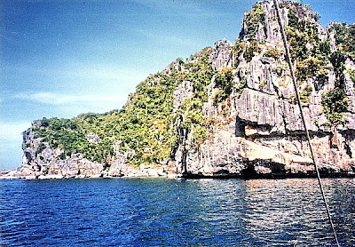
After a hearty breakfast with the whole group at the coffee shop, a hectic schedule of island hopping awaited us.   We left Balbagon Island, together with other resort guests, by 10 AM. on board a large outrigger boat.  Along the way we passed many of the beautiful islands that the Gigantes are known for.  After about 30 mins., we reached our first destination: the southern side of Brgy. Gabi in Gigante Norte Island.  Our boat docked along a steep rocky wall.  As it was high tide, our climbed up the wall was shorter.  Upon reaching the top of the wall, we beheld before us  a hidden lagoon with clear, shallow waters  surrounded by steep and rugged limestone cliffs covered with sparse vegetation.

A hidden lagoon called Tangke

Calm, circular and lake-like lagoons (doubtless from the Spanish word laguna meaning “lake”) such as these are found in low latitude countries such as the Philippines.  They have openings to the sea, always leeward of prevailing winds, but are protected from it by a sandbar or coral reef.  Here, the clear shallow waters rise and fall with the tides.   According to one theory, lagoons are formed when hard coral growth in the center fails to keep pace with those on the periphery.  Waves and storms disintegrate coral in the center and pile them up at the margin, increasing the height of the island which in the course of time become covered by vegetation.

This salt water lagoon before us was locally called Tangke (“tank”).  The lagoon’s rugged limestone periphery, weathered to an incredibly rough surface, are of organic origin.  They are formed by the accumulation of the calcareous skeletons of marine animals and plants, mainly coral and coralline algae.  Its flora is sparse, mostly a few widely distributed strand plants and trees.   Living coral polyps continually extend the fringe. Such was the beauty of the place that we can’t wait to get into our swimming outfits and dip in its shallow, sparklingly clear waters.  Simply Heaven! Other members of the party opted to climb its lofty cliffs in an effort to be physically (and dangerously) nearer to their Creator.  The place is also a 15-min. boat ride east of Sitio Langub.

Little Boracay

After about 30 mins. of lolling around the lagoon, we again boarded our pumpboat for our next destination, a beach called “Little Boracay.”   We arrived at 11:10 AM.  The beach before us was truly a mini-version of the country’s number one destination, albeit shorter.  The other difference is its seclusion.   The beach is backed by a steep, densely-vegetated limestone cliff and because of this there are no resorts. The turquoise waters were just as clear and the white sand beach gradually sloping and fine as sugar, with hardly any shells or pebbles.     Jandy and Cheska were soon off swimming in the shallow waters as our portable monobloc chairs and tables and beach umbrellas were unloaded.  Lunch was served al fresco in food warmers by the beach and eaten kamayan style.  And what a lunch it was!  Tropical paradise at its best.

The sandbar of Cabugao Gamay Island

We would have wanted to stay longer in this beautiful, secluded beach but our itinerary dictated otherwise as we had to leave for our next destination.  After packing our stuff, it was off to another boat ride to an inhabited Cabugao Gamay Island which had a very long, treeless sandbar with beige sand.  We arrived by 1 PM and were greeted by a native selling to us a sea turtle secured by a rope tied around a notch at the rear of its shell.  What a sorry sight.  Poor fellow.  We refused his offer.

After the usual photo shoot for posterity, it was back to our boat for the return trip.  We were back at the resort by 2 PM.  Our island hopping tour was the highlight of our trip to Balbagon and the Gigantes Islands.  Too bad, all good things must come to pass.  The next day, we all left the island early in the morning for the boat trip back to Estancia and the long and tiring land trip to Iloilo City where we had lunch and took the last flight back to Manila, arriving there by 5 PM.

Balbagon Island: Coral Cay Resort (Carles, Iloilo)

Coral Cay Resort in Balbagon Island

The Gigantes Islands, located off northeast Panay in Carles (Iloilo), first came into prominence long before Boracay became a byword  in the tourism industry.  In the 1970s and 80s, its luxurious Sicogon Island Club was one of the first beach resort hotels in the country to achieve international recognition. Its happy days ended when the resort closed down in 1989.  There is more to the Gigantes than just Sicogon as it still has 100 small, rugged, idyllic and fascinating islands, most with white sand beaches, plus hills covered with spectacular first and second growth virgin forests, hidden coves, and many massive wind-carved and steep rock formations containing many deep, cathedral-like granite and marble caves. It also has rich marine life and simple fishing villages inhabited by 300 families.   My wife Grace’s outfit for many years now, E. Ganzon Inc., owned and developed a resort called Coral Cay Resort on Balbagon Island.  We decided to give it a visit after Christmas Day.

Villa Lily Beach Resort in Estancia

I, together with Grace, 11 year old Jandy and 7 year old Cheska left on the early morning Philippine Airlines flight to Iloilo City.  Joining us were Atty. Jose Salazar, his wife and kids and Grace’s fellow E.G.I Properties employees Mr. Disney Sevilla, Ms. Marivic Santiago, Ms. Carol Reyes and Ms. Rhoda Evora.  At the airport, we were picked up by a company van that would take us on a 135.6-km.  (3.5-hr.) long-haul drive to Villa Lily Beach Resort in Estancia, jump-off point to more than 20 of the islands of the Gigantes including Balbagon Island.    

Arrival at Balbagon Island

Upon arrival at the hilltop resort, we waited 30 mins. for the arrival of company boat that would bring us, together with other guests, to the island. The 8 nautical mile long boat trip took about an hour, passing by the large Gigantes islands of Binulangan and Calagnaan as well as the smaller islands of Tabugon, Tulunan-an and Ojastras before reaching the relatively flat, fish-shaped island of Balbagon.  As there was no pier on Balbagon, we alighted a la MacArthur, getting our feet wet before reaching dry land.

The 42-hectare, 1.5-km. long Balbagon Island is located near Gigante Sur Island and is a 20-min. boat ride from the island’s Brgy. Lantangan. Upon our arrival here, we were billeted in one of Coral Cay Resort’s 10 airconditioned cottages. Each cottage, with its bamboo-cladded interior walls and exterior walls cladded with split coconut logs, has its own tiled bathroom and verandah.  This  Class “A” resort also has 25 fan-cooled cottages with bath and a coffee shop/restaurant.

A Balbagon sunset

On our first night on the island, a torch-lit dinner was served al fresco under the stars along its dazzling white sand beach lined with prickly aroma trees. Seafood, consisting of crabs, shrimps and fish, was the “standard” cuisine and was mostly eaten by many in the kamayan style.  The next two days at the resort were packed with stress-free fun: swimming, sunbathing, shell picking, eating, camaraderie, videoke, waiting for the beautiful sunset  or simply just relaxing by the beach and reading a good book.  No work, TV, telephones, pollution, noise and traffic jams. Our 12th wedding anniversary on the 28th (Ninos Inocentes) was spent quietly in much the same way.  Disney and I circumnavigated the island’s 3 km. long shoreline in about 30 mins., passing by a rocky shore where sea birds roost as well as the nearby barangay.  We also walked along the exposed reef at low tide. Along the way, we discovered a beached basket sponge which we brought back to the resort.

Macau City Tour

The next day, after breakfast at the hotel, Grace and I decided to go on a day tour of the nearby Portuguese enclave of Macau via fast ferry from Hong Kong.  This would our first visit to this city renowned for its gambling and annual Macau Grand Prix.

On December 20, 1999, the People’s Republic of China assumed formal sovereignty over Macau from Portugal and it is now one of its 2 Special Administrative Regions (SAR), the other being Hong Kong.

From the hotel, we proceeded to Jordan MRT Station and took the MRT to Sheung Wan Station.  From there, we walked to the HK-Macau Ferry Terminal. High-speed Jetfoils leave here every 30 mins. or so and the trip took an hour.

Macau

Upon arrival at the Macau-Hongkong Ferry Terminal, we proceeded to the terminal’s tourist information desk to inquire on how to tour the city.  We were surprised to find the desk being manned by a Filipino.  He suggested we hire a taxi to go around the city and soon a taxi driver appeared. We placed our trust in our kababayan as he dictated an itinerary to our designated “tour guide.”

Our leisurely taxi ride first took us past  Macau’s Casino on Avenida de Almeida Ribeiro (the main street), to the Fortress of Our Lady of Guia, the highest point on Macau.  Here, we had a good view of the city, the outlying islands, the harbor and the Macau-Taipa Bridge.

Macau-Taipa Bridge

Guia Fortress was designed to defend the border with China but because of its position overlooking the entire city, its chief value has been as an observation post. Built from 1637 to 1638 by Captain of the Artillery, Antonio Ribeiro, Guia fort has 10-ft. high masonry walls, 2 brickwork turrets and occupies 8,600 sq. ft. in a rough pentagon as dictated by the rough terrain.  Its dominating feature is the 52.5-ft. high lighthouse, built in 1865 and the oldest on the China coast.  Its light could be seen for 20 miles in clear weather.

We also had a short walking tour at postcard-pretty Leal Senado Square with its European-inspired architecture of the Leal Senado, shops and pretty fountain.

Leal Senado Square

A substantial part our itinerary were churches and we visited a couple of them.  When Macau was established by the Portuguese, it was expected to be a bastion of Christianity as well as trading post, and they called it “City of the Name of God, Macau.”  Macau became an early center for Jesuit missionary activity.  In 1580, the Bishopric of Macau (which included the Indonesian island of Timor and the Christians of Malacca and Singapore) was created. The first settlers included priests and some of the first buildings were churches, initially constructed with wood and matting.  Later, they were made with taipa (rammed clay) and from the mid-17th century, of stone and plaster.  They were built by Jesuits and other monastic orders with funds provided by the city and the Portuguese crown.

Over the centuries fires and storms have devastated Macau’s churches, but almost all have been restored or rebuilt.  Macau’s multi-colored churches, all named after popular saints (St. Joseph, St. Augustine, St. Paul, St. James, St. Francis Xavier, etc.) as well as the Blessed Virgin (Our Lady of Fatima, Our Lady of Sorrows, Our Lady of Guia, Our Lady of Carmel, etc.), has a predominantly European Baroque flavor with Oriental and tropical features incorporated.  These can be seen in roofs of Chinese tiles, panels of terra cotta and Eastern motifs carved on some facades.

Chapel of Our Lady of Penha

The Chapel of Our Lady of Penha, atop Penha Hill, was founded in 1622 by the crew and passengers which narrowly escaped capture by the Dutch.  The chapel served as a point of pilgrimage for sailors embarking on a hazardous journey.  It was completely rebuilt, along with the Bishop’s Palace, in 1837.

Chapel of Our Lady of Penha

St. Paul’s (Rua de Sao Paolo), the greatest of Macau’s churches and the major landmark of Macau, was built in 1602 and adjoins the Jesuit College of St.Paul’s.  After the expulsion of the Jesuits, the college was used as an army barracks and in 1835 a fire started in the kitchens and destroyed the college and the body of the church.  Now in ruins, all that remained was the magnificent carved stone façade (built from 1620 to 1627 by Japanese Christian exiles and local craftsmen under the direction of Italian Jesuit Father Carlo Spinola) and the grand staircase.

The façade rises in four collonaded tiers and is covered with the statues of the Virgin and saints and carvings of the Garden of Eden, the Crucifixion, the angel, the devil, a Chinese dragon, a Portuguese sailing ship, a Japanese chrysanthenum and pious warnings inscribed in Chinese.

We also visited the Temple of A-Ma.  As with many others in Macau, the temple combines both the Buddhist and Taoist beliefs.  A-Ma (meaning “Honored Mother”) is a much-revered Taoist goddess, the patron of seafarers and the Queen of Heaven.

The history of the goddess goes back to around 1044 AD when in Fukien province (about 350 miles north of Macau), a poor fisherman named Lin gave birth to a baby girl.  At the time of birth a red glow was seen over the house. She grew to be a most remarkable child, never crying, hardworking, obedient and devout.

One day, when the girl was sleeping, she dreamt that two junks carrying here father and brothers were caught in the storm.  In the dream, she stretch out her arms and clenched the masts of the vessels with her fists.  Her alarmed mother, fearing that her child was suffering a fit, shook her by her arm to wake her up, causing her to let go of one of the boats.  Later, when her brothers returned, they told the story of a vision of a beautiful girl that reached out to save them but was unable to hold unto the father’s boat and thus he perished.

Lin died tragically in her early 20’s but stories of miraculous rescues at sea, with the lovely woman calming the waves and bringing the sailors to safety.  Two centuries later, during the Ming Dynasty (1368 to 1643 AD), she was canonized as the First Lady Attendant in Heaven and Protector of Seafarers.  In the years that followed, she was elevated with more titles till finally, in 1683, she was promoted to Tien Hau (Queen of Heaven).

A-Ma has taken on the mantle of the protector of Macau as a whole and people from all walks of life pay homage to her.  Childless women believe that, in her capacity as Honored Mother, prayers to her will help them conceive the child that they long for.

A-Ma Temple was the last item in our itinerary and our guide brought us back to the ferry terminal where we took another high-speed ferry back to Hong Kong.

Return to Hong Kong

Grace’s officemate Ms. Arachel “Chel” C. Borja was leaving for Hong Kong with her kids to accompany her husband who was to attend a convention and Grace and I decided to join them.  We all left Manila for Hong Kong on 6:30 AM flight, arriving at Kai Tak International Airport by 8:10 AM.

This was to be our last entry into Hong Kong via this international airport. Landings at this airport were dramatic to experience and technically demanding for pilots.  A little over a year later, on July 6, 1998, Kai Tak was closed and replaced by the new Hong Kong International Airport at Chek Lap Kok, 30 kms. to the west. There were plans for the site of Kai Tak to be used for housing development.

From the airport, we all took a bus to the city proper and checked out our accommodations at Payless Pension along Nathan Rd..  Grace and I found it quite rundown and decide not to take it.

BP International Hotel – Twin Room

We all had lunch at a MacDonald’s outlet then dropped off Chel and her family at the Hyatt Regency Hotel.  We then decided to check in at one of the BP International Hotel’s 529 guest rooms.

Check out “Hotel and Inn Review: B P International Hotel

B P International Hotel: No. 8 Austin Road, Tsim Sha Tsui, Kowloon, Hong Kong.  Tel: (852) 2376 1111. Fax: (852) 2376 1333. E-mail: enquiry@bpih.com.hk. Website: www@bpih.com.hk.