National Shrine of Our Lady of the Visitation of Guibang (Gamu, Isabela)

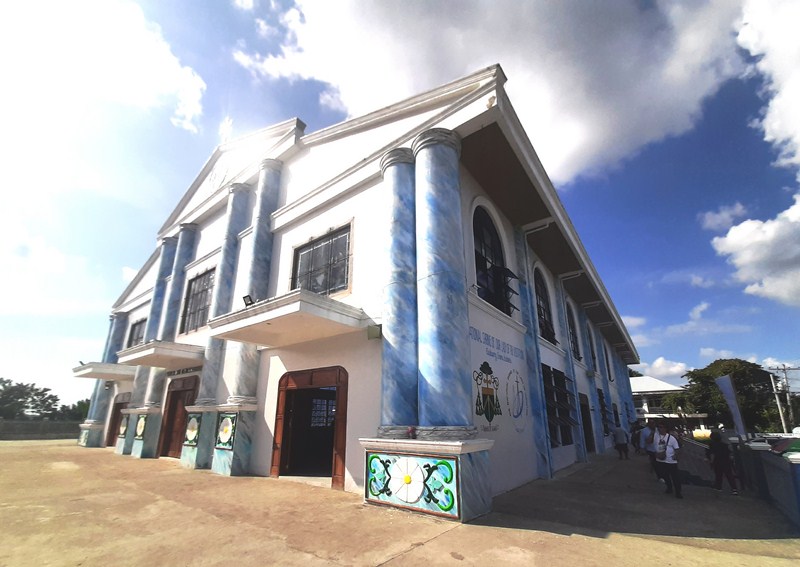
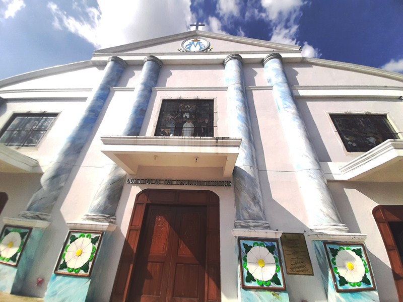
National Shrine of Our Lady of Visitation of Guibang

This pilgrimage site, the Philippines’ eighth national shrine (declared as such on February 13, 1986), is the only national shrine in the northern Ecclesiastical Province of Tuguegarao, comprising the Tuguegarao archdiocese and the Diocese of Ilagan and Bayombong.

It is consecrated to the miraculous pilgrim image of Blessed Virgin Mary of Guibang which was episcopally crowned, by the Most Rev. Carmine Rocco, Papal Nuncio to the Philippines, on May 26, 1973 at the former St. Ferdinand Cathedral (now St. Ferdinand Parish Church) in the City of Ilagan.
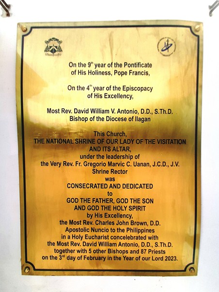
Historical Plaque


The original 750 sq. m. shrine, built in 1726, had a unique façade of layered bricks and stone.  In December 2018, construction of a larger, 1,100 sq. m. church, which can hold around 750 seats and a full-standing area capacity of around 1,200 people, began on the same location.
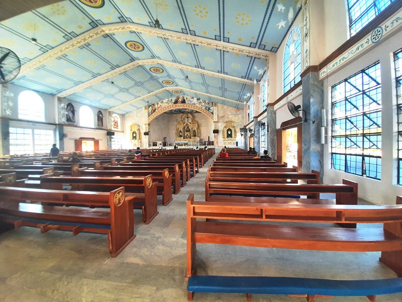
The church interior

While the construction was ongoing, liturgical services and devotional activities were held in the adjacent Poor Clare Monastery.

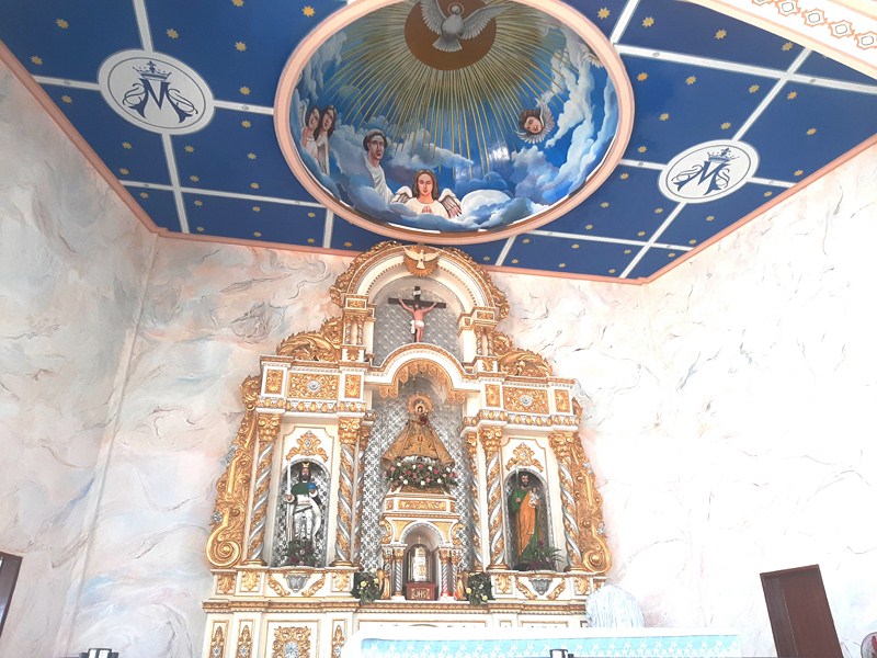
Main altar and retablo

The newly rebuilt and larger pilgrim church was blest and dedicated, by Papal nuncio Archbishop Charles Brown, on February 3, 2023. The church comes alive on July 2 of every year when religious pilgrims from all walks of life come to offer prayers of good health, peace, abundance and good voyage among many other intentions.

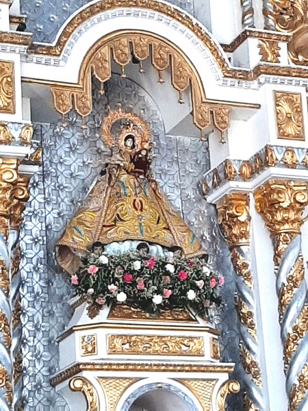
Miraculous image of Our Lady of Visitation of Guibang

National Shrine of Our Lady of the Visitation of Guibang: National Highway, Brgy. Guibang, 3301 Gamu, Isabela.  Mobile numbers: (0920) 503-311 and (0915) 499-1058. E-mail: ourladyofguibang@gmail.com.

Isabela Provincial Tourism Office: Provincial Capitol Complex, City of Ilagan, Isabela. Tel: (078) 323-3146.  Mobile number: (0917) 317-3820.  E-mail: isabelatourismoffice@gmail.com.

Isabela Provincial Information Office: Provincial Capitol Complex, City of Ilagan, Isabela. Tel: (078) 323-0248.  Mobile number: (0927) 395-7555.  E-mail: letters_info@yahoo.com.

How to Get There: Gamu is located 413.4 kms. (a 7.75-hour drive) from Manila and 21.5 kms.(a 30-min. drive) from the City of Ilagan.

Camp Vizcarra Ecology Park (Ramon, Isabela)

Camp Vizcarra Ecology Park

A short, 10-min. drive from Magat Dam, in Ramon town, is the sprawling 30-hectare, peaceful Camp Vizcarra Ecology Camp, a leisure resort and tourist spot, named after the late Angelito F. Vizcarra (the town’s first mayor), connected through the Magat River.

Check out “Magat Dam”

The raging waters, released by the power plant flow from the Magat Hydroelectric Power Plant

Here, you can observed the lush landscape and raging waters of the Magat River, released by the power plant flow from the Magat Hydroelectric Power Plant, from its enchanting, 4-ft. wide steel-wire suspension footbridge, its deck hung below suspension cables on two vertical concrete pylons. Also crossing the river is a nearby concrete bridge.

The 4-ft. wide steel-wire suspension footbridge

Azrael, Ann, Lei, Leony, Jeremae and the author at the footbridge

After crossing the footbridge , a 1,000-step concrete stairway leads up to Mary Hill.

Picnic huts along the riverbank

The two-storey Ecology Hall

Along the way is a gazebo, where you’ll have a birds-eye view of the lush surroundings and the river and, further up, a grotto of Our Lady of Lourdes, where one can pray.

The author (wearing green shirt) crossing the bridge with the others

The park also has cottages, an administration building, a children’s playground, picnic huts (Riverside Hall), the two-storey Ecology Hall and a campsite for Boy and Girl Scout jamborees.

Anne, Patrick, Leony, Lei and Jeremae at the he 1,000-step concrete stairway

View of the river and the Ecology Hall from the gazebo

In the future, a zipline will be built connecting Camp Vizcarra to Magat Dam.

Grotto of Our Lady of Lourdes

Camp Vizcarra Ecology Camp: Brgy. Gen. Aguinaldo, 3319 Ramon, Isabela.  Admission: Php5.  Coordinates: 16°49’7″N 121°28’11″E.

Isabela Provincial Tourism Office: Provincial Capitol Complex, City of Ilagan, Isabela. Tel: (078) 323-3146.  Mobile number: (0917) 317-3820.  E-mail: isabelatourismoffice@gmail.com.

Isabela Provincial Information Office: Provincial Capitol Complex, City of Ilagan, Isabela. Tel: (078) 323-0248.  Mobile number: (0927) 395-7555.  E-mail: letters_info@yahoo.com.

How to Get There: Ramon is located 362.5 kms. (a 7.5-hour drive) from Manila, 64.8 kms. (a one hour and 25-min. drive) from the City of Ilagan and 39.9 kms. (a one-hour drive) from Cauayan City.

Magat Dam (Ramon, Isabela and Alfonso Lista, Ifugao)

Magat Dam

The multi-purpose Magat Dam,  the second largest dam in the Philippines (after the 200-m. high, 1.2-km. long San Roque Dam along the Agno River), is a large rock-fill dam (it consists of 3.1 kms. of rock fill) located along the Magat River, the largest tributary of the Cagayan River (the longest river in the Philippines), used primarily for irrigating about 85,000 hectares (210,000 acres) of agricultural lands, flood control, and power generation through the Magat Hydroelectric Power Plant (the water stored in the reservoir is enough to supply about two months of normal energy requirements).

Magat River

The dam, located approximately 350 kms. (220 mi.) north of Metro Manila, is situated within the boundaries of Namillangan, Alfonso ListaIfugao and RamonIsabela. The Magat River has an estimated yearly water discharge of 9,808 million cu. m. and an approximate crest length of 4,160 m. (13,650 ft.), with its headwaters in the province of Nueva Vizcaya and its confluence, with the Cagayan River, in the province of Isabela. Nearby is the Camp Vizcarra Ecology Park.

Check out “Camp Vizcarra Ecology Park

The author at Magat Dam

Here’s the historical timeline of the dam’s construction:

  • In 1973, the National Irrigation Administration(NIA), with the assistance of the United States Bureau of Reclamation (USBR) and the United States Agency for International Development (USAID), conducted preliminary studies on this multipurpose project. Subsequent detailed and extensive dam site investigation and engineering studies further confirmed the feasibility of NIA’s most daring infrastructure project
  • On May 7, 1975, then President Ferdinand E. Marcos signed Presidential Decree No/ 693 authorizing the construction of th dam and appurtenant structures.
  • In 1978, construction of the Magat Dam started.
  • On October 27, 1982, the dam was inaugurated by Marcos
  • In 1983, the dam started operations.
  • In 2001, after the passage of the Electric Power Industry Reform Act of 2001 (Republic Act 9136), the Magat hydroelectric power plant underwent a privatizationprocess.
  • On January 2006, then President Gloria Macapagal Arroyoinstructed various government agencies to create a rehabilitation plan to improve the lifespan of the dam system.
  • In 2006, SN Power, a Norwegian firm, won the bidding for the plant’s ownership and operation.
  • In April 2007, the National Power Corporation(NAPOCOR) turned over the ownership and management of the hydroelectric plant to SN Aboitiz Power-Magat, Inc. (SNAP-Magat), a joint venture of a local company, Aboitiz Power Corporation (AP), and SN Power.  The National Irrigation Administration (NIA) still owns, operates and manages the non-power components such as the dam, reservoir, and intake gates.
  • In 2009, SN Aboitiz Power-Magat, Inc.began the half-life refurbishment of the Magat Hydroelectric Power Plant  to ensure that the power plant facility remains available throughout its life span
  • In June 2014, the plant’s refurbishment was completed.
  • On November 9, 2020, prior to Typhoon Ulysses’ (internationally known as Typhoon Vamco) landfall, the National Irrigation Administration warned residents of Cagayan and Isabela of Magat Dam’s water release.
  • On November 11, 2020, Typhoon Ulysses  crossed the country, forcing the Magat Dam to release large amounts of water into their impounds. At 24 m., it neared their spilling point, and the dam opened all of its 7 gates, releasing over 5,037 cu. m. (1,331,000 US gal.) of water into the Cagayan River, resulting to numerous riverside towns experienced massive flooding. Waters under the Buntun Bridgewent up as high as 13 m., flooding the nearby barangays up to the roofs of houses.  As a result of the catastrophe, the NIA said that it will review its protocols regarding the release of water in Magat Dam and improve its watershed.
  • On June June 27, 2019, SNAP inaugurated a Php24 million floating solar project, on a 2,500 sq. m. area, consisting of 732 solar panels in a 52 m. floating ring.
  • In 2024, the power plant was augmented by a 24 MW battery.

Entrance to SN Aboitiz Power-Magat, Inc. (SNAP-Magat) compound

Southeast Asia‘s first large multipurpose dam, the 114 m. (374 ft.) high dam is also one of Asia’s biggest dams today. The dam, jointly financed by the Philippine Government and the World Bank (which extended a US$150M loan to finance the foreign exchange requirement), was part of the Magat River Multipurpose Project (MRMP) whose purpose is to improve on the existing Magat River Irrigation System (MARIS) and to triple the production of rice in the Cagayan River basin.

The Alfonso Lista (Ifugao) boundary marker


Industry-generated tourist boats on Magat Dam Lake

With the addition of a US$9M loan from Bahrain (obtained for the purchase of other equipment for the diversion tunnel, soil laboratory and model testing), the total project cost reached US$3.4B (6.5 billion pesos) in 1975.

Magat Hydroelectric Power Plant

The SNAP floating solar project which has the capacity to generate 200 KW of electricity for the SNAP-Magat facilities

The dam was constructed to last for 50 years but increased siltation and sedimentation in the in the Magat River system reservoir, due to slash-and-burn farming, illegal logging,  fish-caging and the July 16, 1990 Luzon earthquake, resulted in the deterioration of the dam’s watershed.

Water pipes, known as penstocks, that direct water to the hydro turbines.


The 500 m. (1,600 ft.) long and 164 m. (538 ft.) wide spillway has 7 sets of radial gates, 2 sets of orifice gates and a discharge capacity of 30,600 cu. m. There are 2 diversion tunnels with a diameter of 2 m. (6.6 ft.) and an average length of 630 m. (2,070 ft.).  The 11.7 sq. km. (4.5 sq. mi.) reservoir has a storage capacity, at full supply level (FSL), of 1.08 billion cu. m., an elevation, at FSL, of 193 masl, a minimum supply level at 160 masl and a maximum flood level at 193 masl.

The Magat hydroelectric power plant, a peaking power plant (it only operates when there is a high demand for electricity in the Luzon power grid, to which the plant is connected), has an installed capacity of 360 megawatts (it is designed to accommodate two more units that will allow it to generate up to 540 megawatts), four turbines ( Francis vertical shaft) and four 90 MW vertical synchronous generators. It is capable of providing ancillary services for the stability of the grid.

Media group at Magat Dam

Magat Dam:  Brgy. Namillangan, Alfonso Lista, Ifugao and RamonIsabela. Coordinates: 16°49′30″N 121°27′14″E.

Isabela Provincial Tourism Office: Provincial Capitol Complex, City of Ilagan, Isabela. Tel: (078) 323-3146.  Mobile number: (0917) 317-3820.  E-mail: isabelatourismoffice@gmail.com. 

Isabela Provincial Information Office: Provincial Capitol Complex, City of Ilagan, Isabela. Tel: (078) 323-0248.  Mobile number: (0927) 395-7555.  E-mail: letters_info@yahoo.com. 

How to Get There: Ramon is located 362.5 kms. (a 7.5-hour drive) from Manila, 64.8 kms. (a one hour and 25-min. drive) from the City of Ilagan and 39.9 kms. (a one-hour drive) from Cauayan City. The dam is connected, by an all-weather road, to San Mateo–Santiago Road, at Oscariz, Ramon, Isabela.  Tricycles, from Ramon, can take you to the dam.