Balicasag Island (Panglao, Bohol)

Balicasag Island Dive Resort

Panglao Island’s deep waters are home to whales and dolphins that appear all year round, especially between the months of April and June.  Having arrived on the last week of May, we were hoping to do some dolphin watching of our own at nearby Balicasag Island which lies off Panglao Reef, 4 kms. southwest of Duljo Point.   Balicasag is also touted as the country’s second best diving spot.  The island’s north and northwest side has a narrow shelf, 10 to 50 m. wide and about 7 m. deep, ending in 2 excellent vertical walls that fall forever.   In fact, 80 to 90% of the tourists who visit Panglao come primarily for the Balicasag scuba diving.  The first recorded dive of the island on the island was done on May 6, 1984.   

On our way

To get to the island, I hired an outrigger boat.  Grace, my kids Jandy and Cheska and my brother-in-law Mark joined me and we all brought our swimming and snorkeling gear, suntan lotion and some packed lunch.  We left very early in the morning for the 10-km. (45-min.) boat ride to the island. However, throughout the boat tour, we failed to sight any dolphins or whales and so we contented ourselves with snorkeling its beautiful underwater scenery just off the shore. 

Balicasag Island

We later made a landfall at the other side of the flat, barren 21-hectare island which is ringed by a pristine sandy shell, coraline beach. The island’s name was derived from the Visayan words bali, meaning “change,” and kasa, meaning “noise,” in reference to the waves slapping the shore as the wind changes direction.  The island was declared as a lighthouse reservation as early as 29 October 1907.  Jandy and I went around the island in less than half an hour.  On the southwest side of the island is the 1.5-hectare, Philippine Tourism Authority (PTA)-managed Balicasag Island Diving Resort, established on April 6, 1987.  Right in front of the resort is a 3.44-hectare marine sanctuary declared by the Department of Environment and Natural Resources (DENR). The resort has 10 native-style duplex cottages with bath and porch, plus a main restaurant pavilion with an adjacent alfresco dining area and bar.  It also has a dive shop offering dive courses.

Loboc River Cruise (Bohol)

After our short bonding with the tarsiers and my church visit, we all returned to the dock where our double-hulled, flower-bedecked floating restaurant was now waiting for us.  The restaurant has 4 long tables, 8 benches, kitchen, mini-bar and comfort room and is pushed along the river by a motorized boat.   We started our cruise from Loay Bridge. Cruising along, we dined on grilled pork or fish, fried shrimps or steamed crabs, all with chopped tomatoes and onions on the side; pansit plus other native fare, all served with generous servings of pandan-scented rice on wooden plates lined with banana leaves.  We washed these all down with either ice-cold soft drinks or the much healthier buko juice.   

Loboc River Cruise

The idyllic rural scenery is also a visual treat.  Along the way we observed heartwarming daily activities like mothers washing clothes and children bathing nude or diving from coconut trees bent precariously close to the water.  We also passed returning floating restaurants and small native outriggers loaded with passengers.  The endpoint of our 2-km.  cruise was Busay (or Tontonan) Waterfalls.  The falls drops 15 m. in 2 stages and is used to generate electricity for the town.   Here, we dropped anchor and guests were given the option to go for a quick, cool swim or just continue chatting or dining.  We just did the latter.  After about 30 mins., the boat made the return trip back to Loboc.   

Busay Falls

Chocolate Hills (Bohol)

From Baclayon, we proceeded to the junction town of Loay and, from there, traveled up north to the town of Carmen and the Chocolate Hills, a destination truly synonymous with the province.  Along the way, we passed some of Bohol’s wonderful scenery, including a man-made forest of mahogany trees in Bilar standing in perfect symmetry along the road leading to Carmen.  Upon arrival at the complex, we ascended 213 concrete steps to reach the observation deck, the hill’s main vantage point.  Early morning and late afternoon (to watch the setting sun) are said to be the best times for photographing this strange and mysterious landscape.  You can also hike between the hills.

Chocolate Hills

This 14,145-hectare Philippine National Geological Monument consists of 1,268 grass-covered, cone-shaped “haycock” hills, a broad, half-kilometer high upland plateau irregularly distributed among the towns of Carmen, Sagbayan and Sierra-Bullones in the east central part of the island.  Formed of sedimentary limestone, shale and sandstone, these 30 to 120-m.  high, beautifully arranged and symmetrically formed hills look like droplets of Hershey’s chocolate, thus their rather sumptuous name.  They also look a delectable chocolate brown during the dry months of April and May, before turning a deep shade of green during the rainy season. 

Church of La Purisima Concepcion de la Virgen Maria (Baclayon, Bohol)

Church of La Purisima Concepcion de la Virgen Maria

We had just finished unloading our luggage and were savoring our welcome drink at our resort when our tourist van arrived to pick us up.  Barely catching our breath, we were again on the move as we had to compress a tight, pre-arranged sightseeing tour around Bohol within the day.   The province has a quite efficient road system with concrete roads encircling the province and traversing the land from Trinidad on the north and Loay in the south.  Besides this, second-class roads also connect the other towns, thereby completing a truly serviceable transportation network.  Touring the island is thus a breeze since travelers can start practically anywhere.  From Panglao, we again crossed the bridge to Tagbilaran City.  About 3 kms. out of the city, we made a photo op stopover at the Blood Compact Site at Brgy.  Bool, the site of the blood compact between Spaniard Miguel Lopez de Legaspi and Rajah Sikatuna on March 16, 1565.

The Blood Compact Site

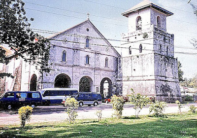
Our first real stop was at the town of Baclayon were we visited the Church of La Purisima Concepcion de la Virgen Maria, one of the best examples of Philippine Baroque combined with Western and Eastern influences.  Reputed to be the oldest church in the country, it was first built by the Jesuit Frs.  Juan de Torres and Gabriel Sanchez in 1595.  The present coral stone church was built in 1727. The church’s simple Early Renaissance facade has a 21-m. high, massive square bell tower (now connected to the church by a portico-façade installed in 1875), a fine porch and massive stone piers (in which some of the town’s priests are entombed.   Inside are an intricately carved, gilded altar and icons plus two side retablos, all dating back to the Jesuit era.  It also has a pipe organ installed in 1824.  The pulpit, installed in 1870, is located at the epistle corner.  The floor’s glazed tiles were installed in 1875 after the completion of the portico. 

Panglao Island (Bohol)

Alona Beach

We all left Cebu City very early in the morning of May 24 via an Oceanjet fast ferry for Tagbilaran City, Bohol’s capital and route center.  Upon arrival at the city’s wharf, we motored, via taxi, to Panglao Island which is connected to the mainland via 2 bridges. The older Taytay Bridge, near the City Hall, goes to Panglao (18.1 kms. away) while the Gov. Jacinto Borja Bridge, located 2 kms. southeast, connects the city’s Bool District with Dauis (3.1 kms. away).  The flat 98.4 sq. km., coralline limestone Panglao Island is located south of the city.    

Lost Horizon Beach Resort

We booked ourselves at an airconditioned room with bath and cable TV at Lost Horizon Beach Resort along Alona Beach.  The resort also has fan-cooled rooms with bath or common bath, a restaurant, swimming pool and a bar.   Alona Beach is one of Panglao Island’s 4 beaches, all of them white sand.  The  other beaches are the 1.2-km. long, pretty shallow Doljo Beach (located between rocky promontories); Dumaluan Beach along the east coast; and Momo Beach on a quiet cove on the west side. 

At Trudie’s Place

The sand off these beaches, although not as fine as that in Boracay, is just as white.  A fact, known only by a few people, is that many white sand beaches on Mactan Island in neighboring Cebu are covered by sand imported from Bohol, including Panglao.  Alona Beach, on the southeast side, is the most beautiful, most popular and, tourist-wise, the most developed beach of the four on the island. This beach, located in Brgy. Tawala, is said to have been named after Alona Alegre, the bomba star of the 1970s whom people say romped naked here during a film shoot.  It has a number of small, individually-designed beach resorts, restaurants, beach bars and dive shops, all spread along the beach for about 1.5 kms..  This attractive, white sand beach is good for snorkeling.  It is, however, clogged with seaweed growing in knee-deep waters, especially between December and March.    

Lost Horizon Beach Resort: Brgy. Tawala, Alona Beach, Panglao, Bohol.  Tel: (038) 502-9099 & 502-9088.  Cebu City booking office: fax: (032) 232-4893. Website: www.losthorizonresort-bohol.com.

Hike to Pintong Alipi Falls (Morong, Bataan)

Morong River

We arrived at Sitio Kanawan in Brgy. Binaritan by 11 AM. A very short hike led us to a pastoral scene of the moderately flowing Morong River fringed on both banks by dense forest and crossed by a hanging bridge of wood planks and steel cables.  Two in our party went ahead to prepare lunch at the Aeta Resettlement Area.  We, however, couldn’t and didn’t resist a cool dip at the river’s inviting waters.  That done, we crossed the bridge and proceeded, along a well-marked trail, toward Kanawan, pausing only to rest at Mang Kit’s mango tree farm.  Kanawan’s 147 households have a mixed population of lowlanders or unat (meaning “straight-haired”) and resettled Aetas or kulot (meaning “kinky-haired”).  The Mt. Pinatubo-displaced Aetas were resettled there in 1987 (through Pres. Corazon Aquino’s Proclamation No. 129) and an Aeta kapitana (captain) currently heads the village.  Every 5 May, the Aetas perform a kabikin or marriage ritual.

Hanging bridge

We arrived at the village just in time for a tinolang manok lunch.  This we attacked with gusto, and justly so as we would need the energy to tackle the long hike ahead.  Laden with water containers, we also secured the services of 48-year old Mr. Iglezerdo “Guilling” Alejo of Task Force Kalikasan as our guide.  After a short hike through rice paddies, our band soon entered the cooling shade of the dense forest.  And dense it really was as about 70% of Morong town is included in the SBMA reservation, with 9,694 hectares identified as watershed primary growth forest area.

The trek begins …..

The hike, through an often well-marked trail strewn with dried leaves and rocks, entailed some dry streambed crossings and quite steep and strenuous mountain climbing.  At the end of this very tiring, almost three-hour hike was the rewarding vista of the well-hidden, 80-foot high Pintong Alipi Falls which is fed by numerous springs sweeping along the mountain.  We relaxed our visibly tired bodies at the cool, refreshing waters of the fall’s shallow pool, as well as enjoyed a back massage underneath the falls itself.  It was truly worth the long hike.

Pintong Alipi Falls

Recharged, we began our return trek to Kanawan, meeting two Aetas gathering honey along the way.  We arrived by 5:30 PM.  After a short rest and some sustenance, we groped our way back to our jeep, our path lit by flashlights.  Our progress back to the town was somewhat stalled by the Good Friday parade of carrozas.   Instead of fretting, we just curiously watched the parade pass us by.  Back at Mang Kit’s house, we hungrily gorged ourselves at supper.  I was just too spent to even walk the short distance back to Vener’s house, collapsing instead to a blissful sleep at Mang Kit’s living room sofa.

Bataan’s Vietnamese Connection

It being Good Friday, we fittingly made plans for a self-imposed, late afternoon Calvary-like hike, up Mt. Agalis, to the remote Pintong Alipi Falls.  Bienvenido “Kit” Nazareno, Vener’s 55-year old uncle, volunteered to drive and accompany us there.  The 30-min. jeepney trip to the jump-off point included passing by the 380-hectare, Subic Bay Metropolitan Authority (SBMA)-managed Bataan Technology Park in Brgy. Sabang. Now being developed as the “Silicon Valley of the Philippines,” this place used to have a humanitarian beginning, it being the former site of the Refugee Processing Center (PRPC), a refugee processing camp for Vietnamese “boat people.”  

A Vietnamese relic at Bataan Technology Park

It was said that the PRPC was among the most comfortable refugee camps in the world.  No barbwire fences and no border soldiers to accost the refugees coming in and out of the camp.  Set up in 1979 under the United States Repatriation Program, it served as a temporary home and transit center for the relocation of Indo-Chinese refugees (Vietnamese, Khmers and Laotians) victimized by the American war in Southeast Asia.  Here, they were trained in English, American history and vocational skills.  The center housed 18,000 refugees at one time and more than 100,000 have passed through here.

Remains of the first Vietnamese refugee boat

Today, the PRPC is no more as it was closed in 1994.  All we saw during transit was a shrine and the rotting remains of the first refugee boat to arrive there.  Vietnamese cuisine, however, has left an imprint in the town.  Near the town hall is a store serving hu-thieu, a soup concoction consisting of sotanghon noodles, sliced hard-boiled eggs, spices and bean sprouts.  We sample this before we departed Morong for Manila.  We, however, missed out on the bun-mi, another Vietnamese-inspired favorite which consists of grilled bun stuffed with pipino, tomatoes, onions and sliced meat with spices, mustard and mayonnaise added.

Holy Week in Morong (Bataan)

Napot Point

After our Dambana ng Kagitingan pilgrimage, it was back to my car again for the final drive to Morong. Along the final 23-km. stretch from Bagac to Morong, we passed the controversial Bataan Nuclear Power Plant, situated 18 m. above sea level at Napot Point.  Morong was the chosen site for this “white elephant,” which was supposed to be the first nuclear power plant in the country.

Begun in 1977, it was constructed by Westinghouse (allegedly under a “conspiracy of corruption”) and was expected to generate 620 MW of electricity when completed.  After much delays (construction was stopped in June 1979 due to the Three Mile Island incident in the U.S.), it was finally completed in 1985 at a cost of US$1.95 billion (its initial budget was US$1.1 billion).  However, cause-oriented groups staged a number of “No Nukes” rallies.

They protested its potential to life and property, and its being built on a major earthquake fault line.  The Chernobyl nuclear plant accident in the former Soviet Union in 1986 was the final nail in its coffin as Pres. Corazon Aquino ordered it mothballed that same year.  To this day, it has not been decided what to do with this overpriced but unsafe complex and the sophisticated equipment already installed there.  In the meantime, the country is left with the problem and an incurred US$2.2 billion debt.

Sunset at Morong

We finally reached Morong late in the afternoon and stayed at Vener’s house, located near the town’s Spanish-era church and a few hundred meters from the beach.  A soothing and well-deserved cool afternoon dip at the beach, augmented by a beautiful fiery sunset, relaxed our tired bodies. Early morning of the next day, Good Friday, provided an opportunity to observe, up close, the countrywide Holy Week ritual of self-flagellation.  I first encountered this shocking and bloody ritual when I was still living in Malibay (Pasay City).  Here in Morong it is called pagbubulyos.   This is performed mostly by men, both young and old, who wish to fulfill a panata (vow) of public atonement for one’s sins.  This panata is done for a minimum of 10 successive years and is reflected in the bulyos, a whip consisting of bamboo strips tied to sturdy cord.   Each strip represents one year of atonement, its number being reduced every succeeding year until he completes his panata.  Each strip should be secured properly.  If one is detached during his rounds, another strip (and another year) is added to his bulyos.

Before the actual flagellation, the flagellant’s back is prepared by beating with stick and paddles until swollen and numb.  Numerous small cuts on the back are then made with razors, with vinegar or salt sometimes applied to the cuts.   Only then is the raw back whipped continuously by the bulyos.  The flagellants, most with heads covered, walk barefoot along the town’s streets, stopping by the church to pray, then continuing on until they reach the sea where a healing noontime dip awaits them.

Biak-na-Bato National Park (Bulacan)

Biak-na-Bato National Park

I got an invitation from Jesu-Mariae School (JMS), my son Jandy’s school, to join an outbound education demonstration tour for teachers at Biak-na-Bato National Park in Bulacan sponsored by Lakbay Kalikasan and I promptly accepted.  Five JMS teachers were to accompany me – Ms. Ofelia “Openg” E. Bermas, Ms. Maritess H. Dimaranan, Mr. Robert V. “Rob” Castañeda, Mr. Joel P. Fatlaunag and Mr. Ronnie Boy R. Lansangan.   

The Balaong River

We left Manila fittingly on April 9, Araw ng Kagitingan, and were picked up, by 5 AM, at the EDSA Shrine by a Lakbay Kalikasan-chartered airconditioned tourist bus.  In all, there were 48 of us from different schools.  Our Lakbay Kalikasan hosts were Ms. Rosa-Vina S. Prudente (Team Leader and Lecturer), Mr. Ryan Viado (Team Leader 1), Mr. Roger Quizol (Team Leader 2), Ms. Hanna Garcia, Mr. Bobby Estrebillo and Mr. Joel Garalde.  We arrived at Biak-na-Bato by 9 AM after a 3-hr. trip (including waiting for latecomers, a stopover for breakfast and calls of nature) via the North Luzon Expressway (NLEX), exiting at Sta. Rita/Baliwag Exit.  Then, from the National Highway, we headed towards Plaridel and Baliwag. At a Y intersection 7 kms. from San Ildefonso, we took the road to the right then,  about 1 km farther, another right at another intersection leading straight to Biak na Bato.

Yungib 2 Cave

This 2,117-hectare National Park, site of Gen. Emilio Aguinaldo’s Biak-na-Bato Republic, covers a large part of San Miguel de Mayumo and parts of San Idelfonso and Doña Remedios Trinidad (DRT).  Its attractions are its series of 16 major caves, some unexplored, that lies at the rocky foothills of the Sierra Madre Mountains. The park is bordered by a small mountain range (the 432-m. high Mt. Nabio, the 422-m. high Mt. Susong Dalaga and the 380-m. high Mt. Silid) in the east and the Balaong River in the west.   It also has low, 140-m. high, rolling hill lands.  Also within the park are Brgys. Biak-na-Bato, Kalawakan and Sibul. The park has two areas: the easily accessible Front Country and the undeveloped and hard to reach Back Country.  

Yungib 3 Cave

It seemed that we weren’t literally going for a walk in the park as our bus entered the Back Country. There are 3 trails leading to the Back Country and its rarely-visited caves.  The trail we chose was well-marked. It starts directly across the Balaong River from the park entrance and proceeds over hills towards Mt. Silid.  We are to explore several semi-caves and at least one pit cave.  From a trail branch to the top of Bahay Paniki Cave, we can also explore 2 more caves without spelunking gear.

Yungib 1 Cave

Reality meets history at this trail as we were going to walk under the blazing heat of the sun through an unpaved, poorly shaded and dusty trail as our Katipunero ancestors did over a century ago.  No pain, no gain.  However,we had the luxury of doing some stretching exercises before our hike. Accompanying us was park guide Mr. Patricio Garcenilla.  Our nostalgic 2-hr. trek took us to 4 caves – Yungib 2, Yungib 3, Tangapan Cave and Yungib 1. The first 3 were naturally lighted and all had at least 2 entrances.  In every cave, we were given a historical overview of what each cave served.  Yungib 2, the so-called Pagamutan (“infirmary”), was, in the past, the nearest cave from the battlefield. Here, in this makeshift hospital, our Katipunero ancestors sought medical help for battle wounds.  Yungib 3, on the other hand, served as the Katipuneros’ storage for weapons, food and other war necessities.

Tangapan Cave

Tangapan (“meeting place”) Cave, near the third trail’s start, was where Gen. Aguinaldo first made contact with other revolutionaries.  Its well-lit main chamber is accessed by a front and back entrance.  A small tunnel, leading to the river, requires the use of helmets and lights for exploring.  Our final destination, Yungib 1, was the longest and the darkest of the four.  Called the “Ambush Cave,” here our Katipunero ancestors would lie in ambush as they waited for pursuing Spanish soldiers.  They escaped via a rear entrance.  We also made our “escape” via the same route, watching our heads as we groped in the dark.  In all 4 caves, we all said a prayer dedicated to our brave ancestors prior to departing. 

Gen. Aguinaldo Cave

After this nostalgic travel through time, it was back to our bus for a short drive to the developed Front Country.  The parking area before the entrance was filled with food stalls selling just about anything from snacks, maps and even souvenirs made from Biak-na-Bato limestone.  This time, we hiked along paved trails straddling the river to our designated picnic area.  Along the way, we passed (but didn’t explore) the Gen. Aguinaldo Cave and Cuarto-Cuarto Cave. Gen. Aguinaldo Cave, also called Biak-na-Bato Cave, was Aguinaldo’s headquarters in 1897 and site of the republic. The Pact of Biak-na-Bato was also signed here.

Bahay Paniki Cave

Once at the picnic area, we pigged out, kamayan style, on a feast of pork adobo, inihaw na talong (eggplant), tokwa (tofu), rice, and a salad of diced tomatoes, onions and salted eggs, all washed down with soft drinks or bottled water. Just when we felt like dozing off, a whistle blew signaling the start of more trekking.  Whatever we ate seemed to disappear as we traversed the paved, up-and-down (mostly up) trail to Bahay Paniki (“House of Bats”) Cave.  This easy-to-explore and well-lit cave is located upstream from the river.  Probably the largest cave in the area, it has a rather deep natural indoor swimming pool fed by an underground stream.  Thousands of fruit bats fly in and out from dawn and dusk.  The presence of these bats also meant the presence of guano (bat droppings), a sure source of income for the inhabitants.  However, it was a cause of concern for those of us who wanted to swim.  What the heck!  A number of us (including me), with or without life vests, dove in and enjoyed the cool waters.

Lakbay Kalikasan: G/F Balai Lakbay, 2 Alondras St., Mira-Nila Homes, Tandang Sora Ave., Quezon City, Metro Manila.  Tel: (632) 932-7818 to 19.  Mobile number: (0917) 500-4796. Website: www.lakbaykalikasan.com.

Trek to Sto. Kalbaryo (Dolores, Quezon)

Pointing to heaven

Finally, we were cleansed enough to climb up Sto. Kalbaryo (Durungawan II to mountaineers), a bare, lava rock-filled mountain located just below Mt. Cristobal.  The highest mountain in Complex 1, it is so called because, during Holy Week, hundreds of pilgrims trace Christ’s supposed ascent from Dolores to the summit, re-enacting Christ’s passion and death.    We were to do ours two weeks early. The hot afternoon sun was still shining brightly up in the sky as we clambered our way, thirsty and sweating profusely, through a well-marked trail, up the treeless and rocky mountain.

The author with Rob and Ely

Throughout my trek, I also felt the mystique and magic of Mt. Banahaw and Mt. Cristobal around me, more so when we reached the top where 3 wooden crosses were strategically planted to recreate the actual crucifixion scene. By tradition, on Good Friday, the summit is deserted, as mystics believe that only God the Father may bear witness to His Son’s death.  It is also said that on that same day, an enkanto (spirit) opens a hidden cave near the crosses which acts as a pathway to the netherworld.  Anyone at the summit, at this time, will be forced to enter it and never return.  Reaching the summit of a mountain was a first for many of my companions. For me, it brought me 2,400 ft. nearer to Heaven and my Creator.    Thus, it was with deep regret and a heavy heart that I had to make the shorter but more difficult descent down the mountain and back to earth.  For me, my climb up that mountain has been well worth it as this most jaded of travelers has left it purer in heart.

Lakbay Kalikasan: G/F Balai Lakbay, 2 Alondras St., Mira-Nila Homes, Tandang Sora Ave., Quezon City, Metro Manila.  Tel: (632) 932-7818 to 19.  Mobile number: (0917) 500-4796. Website: www.lakbaykalikasan.com.