
I still had the whole morning for sightseeing on our fourth and last day in Taipei so I availed of the Northern Coast Tour (Keelung City) offered by Edison Travel Service (NT$1,000/pax). After breakfast at the hotel, Jandy and I, as well as a 69 year old retired USAF serviceman named Gerald and his wife Leona, were picked up at the hotel lobby by our tour guide. The sun was already up and shining (this after 3 days of rain) when we boarded our van for the 45-min. drive to Keelung City. Nicknamed the “Rainy Port” (due to its frequent rain and maritime role), Keelung City is Taiwan’s second largest seaport (after Kaohsiung).

Keelung City Proper
From the city proper, our van drove up a hill, east of the city, to Chung Cheng Park (derived from Chiang Chung-cheng, a given name of Chiang Kai-shek). Situated on the side of Ta Sha Wan Shan, atop a hill off Hsieh Road, Chung Cheng Park (also spelled as Jhongjheng Park) was formerly called Kang Park in the past. The first immigrants to Taiwan used to fight with each other for land. In order to stop these disputes, they set up a temple for yearly worship. During the Japanese occupation, the temple was in Kao Sha Park and later moved to Chung Cheng Park.

Entrance to Chang Chung Park
There are three levels in the park. On the first level is a historic cannon fort. On the second level is a Buddhist library, Chung Lieh Temple and Chu Pu Tan Temple. The temple attracts many worshipers on July 15, the Chung Yuan (Hungry Ghost) Festival, when families lights a lamp in front of their door in order to light the way for ghosts at night.

Chang Chung Park
Our destination was the Kuan Hai Pavilion, on the third level. Here, we had a scenic view of Keelung City, its excellent 2,000 m. long and 400 m. wide harbor (embraced by mountains to its east, west and south); luxury passenger ships; smaller commercial craft; naval and coast guard vessels: and the azure Pacific Ocean.

Naval and commercial ships

Dock facilities

The city proper
Also here is the 22.5 m. (74-ft.) high, white smiling statue of Guan Yin (the Buddhist message of compassion and peace), the Buddhist Goddess of Mercy. The landmark of Chung Cheng Park, it is the biggest goddess statue in Southeast Asia. Inside the statue, Jandy and I climbed a steep stairway leading to the top. From portholes on the sides, we could take in views of the harbor and the city.
")
For me, Chung Cheng Park is a combination of a Buddhist holy site and amusement theme park. The grounds by the Guanyin statue are crowded with snack vendors and souvenir shops while toy vehicles for children to ride around on, some of them musical, are offered for rent.

The souvenir shop and children’s rides for rent
Behind the statue is a Buddhist temple. We noticed a backwards swastika, a Buddhist symbol of peace (as opposed to the forward facing Nazi symbol), on top of a bell tower (you can ring the bell for a NT$50 donation). Further downhill are several 3-storey pagodas, a museum and a martyrs’ shrine. Since this park is near downtown, it is popular with city folk as well as tourists.

The backward swastika symbol
Chung Cheng Park: Keelung City, Taiwan. Tel: (+886-2) 2428-7664.
How to Get There: take 206 bus and stop at provincial hospital. The park entrance is on the other side.
Taipei 101 Indoor Observatory (Taiwan)

Our primary purpose for visiting Taipei 101 was to get 360-degree views of the city which attract visitors from around the world. This is made possible either through the 383.4 m. (1,258 ft.) high Indoor Observatory at the 89th floor or the 391.8 m. (1,285 ft.) high Outdoor Observatory at the 91st floor, the second-highest observation deck ever provided in a skyscraper and the highest such platform in Taiwan.

Inside the high-speed elevator
From the shopping mall, Jandy, Isha and I went up to the 5th floor to purchase our admission tickets (NT$450/person, around US$13), me paying via my Mastercard credit card and Isha paying in cash. As it was drizzling outside, we weren’t allowed to go out the Outdoor Observatory.

The Damper Baby mascot
Upon purchase of our tickets, we all queued, at a long line (it being a Sunday), for our turn at one of the 2 high-speed, double deck elevators (which access’ the 88th through 91st floors) built by the Japanese Toshiba Elevator and Building Systems Corporation (TELC). While on line, all visitors are requested to pose, for souvenir photos, beside a picture of Taipei 101. Isha posed alone while Jandy and I posed together. The resulting photoshopped photos can then be purchased at the Indoor Observatory (NT$400 for Isha’s single pose and NT$600 for our joint pose). We didn’t bite at the offer.

Taipei 101 Indoor Observatory
Once inside the NT$80 million (US$2.4 million) elevator (which accommodates 24 persons or 1,600 kgs.), we could still hear our ears pop (in spite of its atmospheric pressure control) as we ascended 1,010 m. per min., which is 16.83 m./sec. (55.22 ft./sec.) or 60.6 kms./hr. (37.7 miles/hr.). We arrived at the 89th floor in 39 secs. flat. In 2004, the elevator held the the Guinness World Record of the world’s fastest passenger elevator. Each elevator, which features an aerodynamic body, has state-of-the art emergency braking systems and the world’s first triple-stage, anti-overshooting system.

Special exhibit
Upon arriving at the 89th floor Indoor Observatory, we were welcomed by the Damper Baby mascot. Before exploring on your own, we were given a free multimedia guides to listen to, with recorded self guided voice tours, in 8 languages, detailing sights and the history of the Taipei Basin from 30,000 years ago to the present. While listening, we all went around to appreciate the somewhat hazy view of the entire city from large, blue green-tinted windows with UV protection. Green mountains seem to embrace the valley city of Taipei. Appropriate labels and names of the buildings and structures are posted to assist visitors. There were also informative displays and special exhibits.
")
Taipei City Hall (foreground)
")
Taipei World Trade Center Hall 1 (foreground)
The observatory also has an outlet of Big Tom’s Ice Cream. Posted flavors here include “Obama Brownie,”“L.F. Marionberry Cheesecake,” “Soy Cream Cinnamon Caramel” and more. Like most ice cream joints, you can choose to get your scoops in a waffle bowl. They also offer bagels, cakes, waffles, freshly ground coffee, tea, orange juice and other specialty items to go with your ice cream.

Big Tom Ice Cream
Taipei 101 Indoor Observatory: 89/F, No.7, Hsin Yi Rd., Section 5, Taipei 110, Taipei City, Taiwan. Tel: (+886-2) 8101-8899. Website: Taipei-101.com.tw.
Malay to Nabas Tour (Aklan)
On our third day in Aklan, my good friend Gil Bilog (my wife Grace’s first cousin on her mother’s side) and I had our breakfast at our usual hangout, Seaside Restaurant , Malay poblacion’s (town center) only full-service restaurant which is owned and operated by Ms. Myra Oczon (Grace’s niece) and her husband Dodoy. Both also work at the nearby Municipal Hall. As the name implies, the restaurant is located by the sea, along the poblacion’s clean, gray sand beach. At night, during supper, we could hear and feel the surf pounding the sea wall. Along the beach, we could see the lights along Boracay‘s long beach as well as faintly hear the sounds of its active nightlife.
 |
| Malay Poblacion Beach |
The native-style restaurant serves a number of Filipino dishes (including my favorite sisig and Gil’s favorite sinigang) and grilled dishes (fish, chicken, pork, squid, etc.) and also has picnic sheds for those who want the feel of the sea breeze as well as get a panoramic view of distant Boracay Island and its well-known white sand beach. There’s also a pension house with rooms with bath for transients.
 |
| Seaside Restaurant |
In the afternoon, I decided to tour Gil to the nearby town of Nabas to explore its Union Beach. For lunch, I drove the Mitsubishi Adventure the 6 kms., with Gil and Carl Flores (Grace’s first cousin on her father’s side), along the now completely concreted road, to Andok’s at Brgy. Caticlan’s Jetty Port. It was already starting to rain when we finished lunch and it remained so as I drove the 20 kms. along the scenic coastal highway to Nabas.
 |
| Union Beach Resort & Lodge |
Along the way, at the left of the highway, we had a stunning vista of unspolied white sand beaches, the likes of which were similar to Boracay before the advent of tourism. We made a stopover at Union Beach Resort & Lodge where we had hot coffee and a long chat at one of its elevated picnic huts. As it was the amihan season, the resort had set up screens to prevent wind-blown sand from bothering guests.
 |
| Gil, me and Carl along Union Beach |
During a break in the rain, we made our way through the opening in the screen to walk along the beautiful, palm fringed white sand beach. Boracay and its offshore islands can also be seen in the distance, northwest of the beach. At a nearby point of land, Carl pointed out a property owned by host and comedian Ariel Ureta. The resort also has small airconditioned rooms with bath and cable TV for those who want to stay longer in quiet surroundings.
 |
| Carl and Gil at Tabon Docking Area. Behind is Laurel Island |
It was again starting to rain when we left the resort. Driving back to Malay, we made a short stopover at the Tabon Docking Area where boats from Boracay drop off their guests when rough seas prevent their docking at Caticlan’s Jetty Port. The concrete docking area was now cracked in places and in dire need of repair. Across the port, we had a good view of the rocky, aptly named Crocodile Island, other offshore islands as well as Laurel Island and its white sand beaches.
 |
| Crocodile Island |
Before returning to Malay poblacion, we made another stopover at Nimya Flores-Thompson’s beautiful seaside house in Brgy. Motag. Ate Nimya, a long time Australian resident and citizen whose British husband Bill died some years ago (in fact, on November 1, All Saints’s Day), spends part of the year in her home in Malay. The house is protected from the sometimes raging sea by a concrete sea wall.
 |
| Ate Nimya’s beachside house |
Nimya entertained us from her porch facing the clean gray sand beach and the sea. She also has a small separate cottage which she rents out to expats (it was then occupied). Nimya’s neighbors are also expats who married Filipinas. They also built beautiful homes in this equally beautiful seaside setting.
 |
| Brgy. Motag’s gray sand beach |
Union Beach Resort & Lodge: Brgy. Union, Nabas, Aklan. Mobile numbers (0949) 750-5177 and (0921) 762-7564.
Marina Bay Sands SkyPark (Singapore)
The next day was to be my niece Jaja’s wedding day but, since it was to be held in the late afternoon, Jandy and I still had the whole morning for sightseeing. After breakfast at our hotel, we took a taxi to the 20-hectare Marina Bay Sands, an integrated resort fronting Marina Bay officially opened last June 23, 2010, after a partial opening (which included the casino) on April 27. Designed by Moshe Safdien Architects (with Aedas Singapore as the local architect of record), its engineering was provided by Arup and Parsons Brinkerhoff (which had originally worked on such prestigious projects such as the Beijing National Aquatics Center and the Sydney Opera House) and the main contractor was Ssanyong Engineering and Construction. The resort’s architecture as well as major design changes along the way were also approved by the late Master Chong Swan Lek and Master Louisa Ong-Lee, its feng shui consultants.

Marina Bay Sands
Developed by Las Vegas Sands, this S$8 billion (including cost of the prime land) casino is billed as most expensive stand-alone atrium casino in the world, with 500 tables and 1,600 slot machines. However, we were not visiting for the gambling. Rather, we were there for the 360-degree Singapore skyline view atop its 340m-long (stretching longer than the Eiffel tower laid down or four and a half A380 Jumbo Jets), 1-hectare and 3,900-pax SkyPark, a sky terrace which connects the three 55-story hotel towers and is set on top of the world’s largest, gravity-defying public cantilevered platform, overhanging the north tower by 67 m..

Marina Bay Sand’s atrium lobby
Aside from housing the world’s largest casino, the resort features a 2,561-room hotel, a 1,300,000-sq. ft. (120,000 m2) convention-exhibition center, the 800,000 sq. ft. (74,000 m2) The Shoppes at Marina Bay Sands mall (with over 300 stores and F&B outlets), the 200,000 sq. ft. (19,000 m2), lotus-shaped ArtScience Museum located next to the three blocks (currently featuring “Titanic: The Artifact Exhibition”), two large theaters (the 1,680-pax Sands Theater and the 2,155-pax Grand Theater), two floating Crystal Pavilions (the 2nd houses the world’s largest Louis Vuitton boutique) and a 6,500 sq. ft. (600 m2) indoor ice skating rink (which uses artificial ice). There are also 7 “celebrity chef” restaurants (6 within the Shoppes) – Cut, Waku Ghin, Pizzeria and Osteria Mozza, Guy Savoy, DB Bistro Moderne, Santi and Rasapura Masters.

The lotus-shaped ArtScience Museum
Upon arrival, we entered the hotel’s huge atrium lobby, decorated with tall Christmas trees, and walked some distance to the SkyPark Box Office located at the Basement 1, Tower 3. After purchasing our entry tickets here, we proceeded to the porte cochere area outside the Tower 3 and took the elevator to 57th floor where the SkyPark is located. The SkyPark is also home to the world’s longest elevated outdoor swimming pool, perched 191 m. above ground and with a 146-m. (478-ft) vanishing edge. However, we missed out to view the pool (as well as its lush gardens and rooftop The Sky on 57 restaurant) as it is available only to 50 observation deck guests that have registered for the 15-min. guided tours (available at 10 AM, 2 PM and 9 PM only). The pools were made with up to 422,000 pounds of stainless steel and can hold 376,500 gallons (1,424 cu. m.) of water. Within the observation deck is the KU DÉ TA nightclub.

.
The day, though slightly overcast, still afforded us a spectacular, unforgettable panoramic view, from 10 observation deck view points, of Singapore’s Central Business District, the Merlion, Old Supreme Court Bldg., New Supreme Court Bldg., City Hall Bldg., Esplanade, St. Andrews Cathedral, Float @ Marina Bay, Helix Bridge, the Singapore River, the Formula One pit building and racetrack, the Padand (Singapore Recreational Club and Cricket Club), Marina Barrage, East Coast Parkway, Benjamin Sheares Bridge, Changi Airport control tower, the Singapore Flyer (an observation wheel), Nicoll Highway, Little India, Sentosa Island, Singapore Port and, beyond, Kusu Island and Indonesia’s Batam Island. Just below are the resort’s theaters, the Event Plaza, the Crystal Pavilions, the Sands Expo and Convention Center, the ArtScience Museum, the Marina Bay Sands casino and The Shoppes at Marina Bay Sands.

The Singapore skyline
Marina Bay Sands SkyPark: Open daily, 9:30 AM-10 PM (11 PM on Fridays, Saturdays and Sundays). Admission Fee: S$20 for adults, S$14 for children (aged between 2–12 years) and S$17 for senior citizens (aged 65 years and above). Children under 2 years of age may enter for free. Ticketing Hotline: +65 6688 8826
The Halsema Mountain Highway
After breakfast at the Albergo Hotel in Baguio City, Jandy and I packed just enough clothes for our 2-night stay in Sagada (Mountain Province) and left the rest at the Front Office. From the hotel, we took a taxi to G.L. Liner terminal at the Dangwa Compound along Magsaysay Ave., fronting the Baguio Market. We just missed the previous Sagada-bound bus by minutes so we paid the fare for the next bus, scheduled at 10:30 AM. We spent the next hour at the Baguio Cathedral, climbing the steep stairs along Session Rd. to get there. Here, we had snacks at the coffee shop within the compound before returning to the terminal.
 |
| The now paved Halsema Highway |
A few after our return to the terminal, our designated bus arrived and we boarded the bus, sitting up front, to the right of the driver. Soon, sacks, farm produce as well as luggage and bags were also being loaded around our area, making alighting a problem later for us. We left the terminal just before 11 AM but, just before the interchange leading to La Trinidad Rd., traffic slowed us down due to road rehabilitation. After 30 mins., we left the hustle and bustle of Baguio City and La Trinidad and were now on our way on our long-haul, 6.5-hr. drive to Sagada via the Halsema Highway, the highest highway system in the country.
 |
| Landslides and road slips are still a common occurence |
Formerly called the “Mountain Trail,” this spectacular 146-km. (95 kms. of which are in Benguet) highway traverses Benguet from south to north. Named after Eusebius Julius Halsema (American civil engineer and mayor of Baguio City, 1920 to 1936), it links La Trinidad and Baguio City with Bontoc, Sagada (151 kms.) and Banaue (196 kms.), cutting through mountain peaks, gorges and steep cliffs. This highway was originally a foot trail used by mountain folk between Bontoc and the foot of Mt. Data. U.S. Army engineers improved and widened it. They also built a new winding road through precipitous slopes and traversing high ridges between Acops and Abatan, The road reached Natubleng in 1928 and more than half its length (to Bontoc) was completed in 1931. All told, the highway took more than 15 years to build and was finally completed in 1936.
 |
| Fog can reduce visibility of the driver |
Tracing a circuitous path, this road crosses the massive Cordillera Central mountain range, crossing deep ravines and skirting dangerous slopes. Jandy and I have passed this way before (in 1998), more than half the road then being unpaved, bumpy, rough and dusty. Today, about 95% of the highway is”paved.” Still, landslides are a constant hazard here and big stones and debris tumble from peaks, especially during the rainy and typhoon season. Occasional fog can also ruin a driver’s visibility. However, then and now, we stilled passed through some of the most spectacular mountain vistas found anywhere – magnificent, stonewalled rice and vegetable terraces; swift-flowing rivers spanned by hanging bridges; roadside waterfalls; pine-clad mountains; picturesque villages; etc..
 |
| Vegetable terraces |
 |
| Highest Point Marker in Atok |
About 3 hrs. past Baguio City, we passed (but did not stop at) the Highest Point Marker (Philippine Pali), along Km. 53 (Km. 303), Brgy. Cattubo near Bayangan in Atok. Here, the road crosses 2,450-m. high Mt. Paoay. The highest point of all Philippine highways (7,400 ft. or 2,225 m. above sea level), its viewpoint has good views of Mt. Pulag, Mt. Timbac, Kabayan, Atok and the deep Agno Valley to the south (cloudy during the rainy season).
 |
| A beautiful, terraced mountainside |
Along Km. 63 are the vast Natubleng Vegetable Terraces of Brgy. Natubleng in Buguias. Here, neat rows and upright trellises are planted with temperate-zone climate greens such as Baguio beans, cabbage, carrots and other vegetables and root crops. We also passed the urbanized townships of Sayangan (Atok) at Km. 54 and Abatan (Buguias) at Km. 90.
 |
| The township of Abatan in Buguias |
Sta. Cruz: Laguna’s Provincial Capitol
 |
| Laguna Provincial Capitol |
It was already late in the afternoon when Jandy and I arrived at Sta. Cruz town, Laguna’s provincial capital and one of the province’s 2 main route centers (the other is San Pablo City). The health, education, transportation, commerce and social services center for the entire province, Sta. Cruz also serves as the business and commercial hub particularly for the predominantly rural northeastern towns of Cavinti, Famy, Luisiana, Mabitac, Majayjay, Nagcarlan, Pakil and Pangil.
 |
| Sta. Cruz Municipal Hall |
Formerly a part of Lumban, it became a separate municipality in 1602 and was made into the provincial capital in 1858, replacing Pagsanjan. This town is made famous for its delicious kesong puti (salty white cottage cheese). This native delicacy, made from carabao’s milk, is cooked in large vats to which salt and vinegar is added till it curdles. The cheese is then fermented, strained and molded and then individually wrapped in banana leaves.
 |
| Church of the Immaculate Conception |
Upon arrival at the town, I parked the Revo across the blue and white municipal hall at the town plaza. The town’s layout seems to be broader than most Laguna lakeside settlements. Sta. Cruz, however, has no natural tourist attractions, only man-made. Near the plaza is the Church of Our Lady of the Immaculate Conception.
 |
| Old Provincial Capitol Building |
After merienda at a MacDonald’s outlet nearby, we proceeded to visit the Provincial Capitol Building along P. Guevarra St.. Also within the compound is the old provincial capitol. Our visit to Sta. Cruz capped our Laguna joy ride and we proceeded on our 87-km. drive back to Manila.
Mayor’s Office: Municipal Hall, Poblacion, Sta. Cruz, Laguna. Tel: (049) 808-1008
A Walking Tour of Mauban (Quezon)
 |
| The Municipal Hall |
We finally arrived at Mauban, at the midst of its Maubanog Festival, by 4 PM and we made a stopover at the municipal hall were we all dropped by the Municipal Tourism Office and paid a courtesy call on Mayor Fernando Q. Llamas, the uncle of our good friend Lee Llamas. Prominently displayed outside the municipal hall is an old cannon, 1 of 3 (the other 2 are at the Museo ng Mauban) bestowed by Spanish Gov.-Gen. Rafael Maria Aguilar to the town as a reward for the rescue efforts done for the Spanish friars captured by Moro pirates. The cannon were later used against the Spanish to effect the surrender of Tayabas to the revolutionaries in 1898. All 3 were restored on April 16, 2004.
 |
| Traditional Mauban products |
After our courtesy call on the Mayor, we all dropped by the Mauban Product Development Office, beside the municipal hall, to check out the town’s traditional products such as finely-crafted nilala woven hats, baskets, slippers, wallets, bags, boxes, caddies, etc.; delicacies such as pinangat, binalawan, pinais, tikoy, kalamay, pastillas, botarts, mazapan, suspiro, etc.; and nipanog, wine made with sasa (toddy palm nectar) instead of coconut and available in different flavors such as liputi, katmon, guyabano, mango, pineapple, guava, jackfruit, kalamias, tamarind and santol. Being a fiesta, booths selling these products, and more, were found in front of the municipal hall as well as along the major streets.
 |
| Church of St. Bonaventure |
While they were checking out the products, I took time out to visit the town’s present, modern Church of St. Bonaventure (the town’s patron saint). This church underwent a lot of rebuilding since it was first built in 1647 and demolished in 1769. The second structure, built in 1773, was badly damaged during the 1830 earthquake and rebuilt between 1836 and 1845. The church collapsed during the July 1880 earthquake and the present church was built in 1891. The bell tower, built in 1773, was seriously damaged during the 1880 earthquake and the portion that remained was partially destroyed again during the August 20, 1937 earthquake.
 |
| Gat Uban Park |
With the sun still up, we still had time to make a walking tour to Gat Uban Park, at the end of Gomez St., along the sea wall. The park has a seaward facing statue the legendary Dumagat warrior and leader Gat Pangil who defended the town against ruthless Moro attacks. Gat Pangil was also known as Gat Uban because of his gray hair (uban). Accordingly, the town was named after the fact. The well-lighted promenade area, with its gentle sea breeze, is a favorite meeting place for Maubanons.
 |
| View from Rizal Hill Park |
It was near sunset when we dropped by Rizal Hill Park (locally called Calvario Hill), along San Buenaventura St. in Brgy. Rizaliana. To get to the top, we had a choice of taking the shorter route (climbing a steep concrete stairway) or the longer route via a winding ramp skirting the hill. Of course, we chose the latter. At the top of the hill is a statue of National Hero Jose Rizal, erected on December 1912 by the Mauban Circle Association of Students. The park offers a panoramic view of the whole town. In olden times, the hill was used as a sentinel post and a place for religious activities during the Spanish era, as headquarters by American troops, as an outpost by the Philippine Constabulary during the Japanese Occupation and, after the war, by the Civilian Emergency Administration.
 |
| Rizal Hill Park |
Soon after our arrival, Mr. Ludovico Badoy and Ms. Carminda R. Arevalo, Executive Director and Officer-in-Charge (NHCP Research, Publications and Heraldry Division), respectively, of the National Historical Commission of the Philippines (NHCP), formerly the National Historical Institute (NHI), also arrived. They supervised the installation of a historical marker recognizing the hill for its historical significance. The marker was to be unveiled the next day, with Mayor Llamas and Mr. Badoy leading the ceremony. It was now evening when we left the hill and, after dinner at the house of Mayor Llamas, we were billeted for the night at the nearby Llamas ancestral house.
Municipal Tourism Office – Municipal Hall, Poblacion, Mauban, Quezon. Tel: (042) 784-1205 and 713-0314. E-mail: gat_uban@yahoo.com.
The Busig-on River (Labo, Camarines Norte)
 |
| Nipa palms along the Busig-on River |
We left Quinamanukan Island by 3:15 PM, the mainland just a 30-40 min. boat ride away. Upon reaching the mainland, our boat made its way inland via the wide but sometimes shallow Busig-on River (the province’s longest river system), its muddy banks lined with nipa and coconut palms and backdropped by the 997 m. high Mt. Balagbag (known as the “Sleeping Giant”). Every now and then, small, outrigger-less and high-bowed bancas would pass us by. After negotiating a bend in the river, we finally reached port by 4:30 PM. Amable Miranda of the Camarines NorteTourism Office was already waiting for us there. After dining on angko, a local delicacy I bought and shared with the others, Amable drove us to Tabea Reichan Restaurant at Vinzons town proper where we had our “late” lunch. After picking up our luggage at the Municipal Guest House along Bagasbas Blvd. in Daet, Amable drove us to the nearby, upscale Bagasbas Lighthouse Resort, Daet’s premier resort, where we were to stay (my second) for two days.
Tabea Reichan Restaurant: Poblacion (just across the municipal hall), Vinzons, Camarines Norte
Bagasbas Lighthouse Hotel Resort: Bagasbas Blvd., Daet, Camarines Norte. Tel: (054) 441-5855. Mobile number: (0916) 520-6783. E-mail: info@bagasbaslighthouse.com. Website: www.bagasbaslighthouse.com.
Back to Camarines Norte
 |
| Municipal Guest House |
For the third time this year, I was again invited to visit Daet, in Camarines Norte, this time to cover its Pinyasan Festival as well as the 150th birth anniversary of Jose Rizal, the town being the site of our National Hero’s first monument. I was joined by event organizer Mr. Bernard Supetran, professional photographer Mr. Lee Llamas, travel writers Mr. Timothy Jay “TJ” A. Ibay of What’s On and Ms. Karla Marcia Rey, and travel blogger (and Karla’s boyfriend) Mr. Orlando “Lan” Cajigal. We all left via a 9 PM airconditioned bus at the Philtranco terminal in Pasay City, all sitting at the rear of the bus. This was to be my first long-haul bus (8-9 hrs.) trip to Daet, my first being by plane to Naga City (plus a 2-hr. van drive back to Daet) and the two others by van.
 |
| Surfer’s Dine Inn |
Our 6 AM arrival at Daet was heralded with a crash as our bus’ roof scraped the low ceiling of the bus shed. Poor bus driver (salary deduction). Our trusty driver from the Provincial Tourism Office, Mr. Amable Miranda, was on hand at the terminal to pick us up with a van. We were first brought to Surfer’s Dine Inn, along Bagasbas Blvd., for an early Filipino breakfast (mine was pork chops). Here, we were met by Provincial Tourism Officer and good friend Atty. Debbee Francisco. Amable then brought us to the Municipal Guest House, also along Bagasbas Blvd., where we freshened up and rested for a short while. We were all slated to go overnight camping at Tinaga Island, one of the famed Calaguas Islands. This was to be my second visit and the first for the rest.We left Bagasbas by 8 AM for the leisurely drive to Minaongan Fish Port in Paracale, bringing along just enough personal necessities for our overnight camping (plus some borrowed pillows and blankets from the guesthouse). The national highway unusually passed through the gated property (which was closed at night) of the modern Cathedral of the Most Holy Trinity (consecrated on September 1, 1984). Here we made a brief stopover for photo ops.
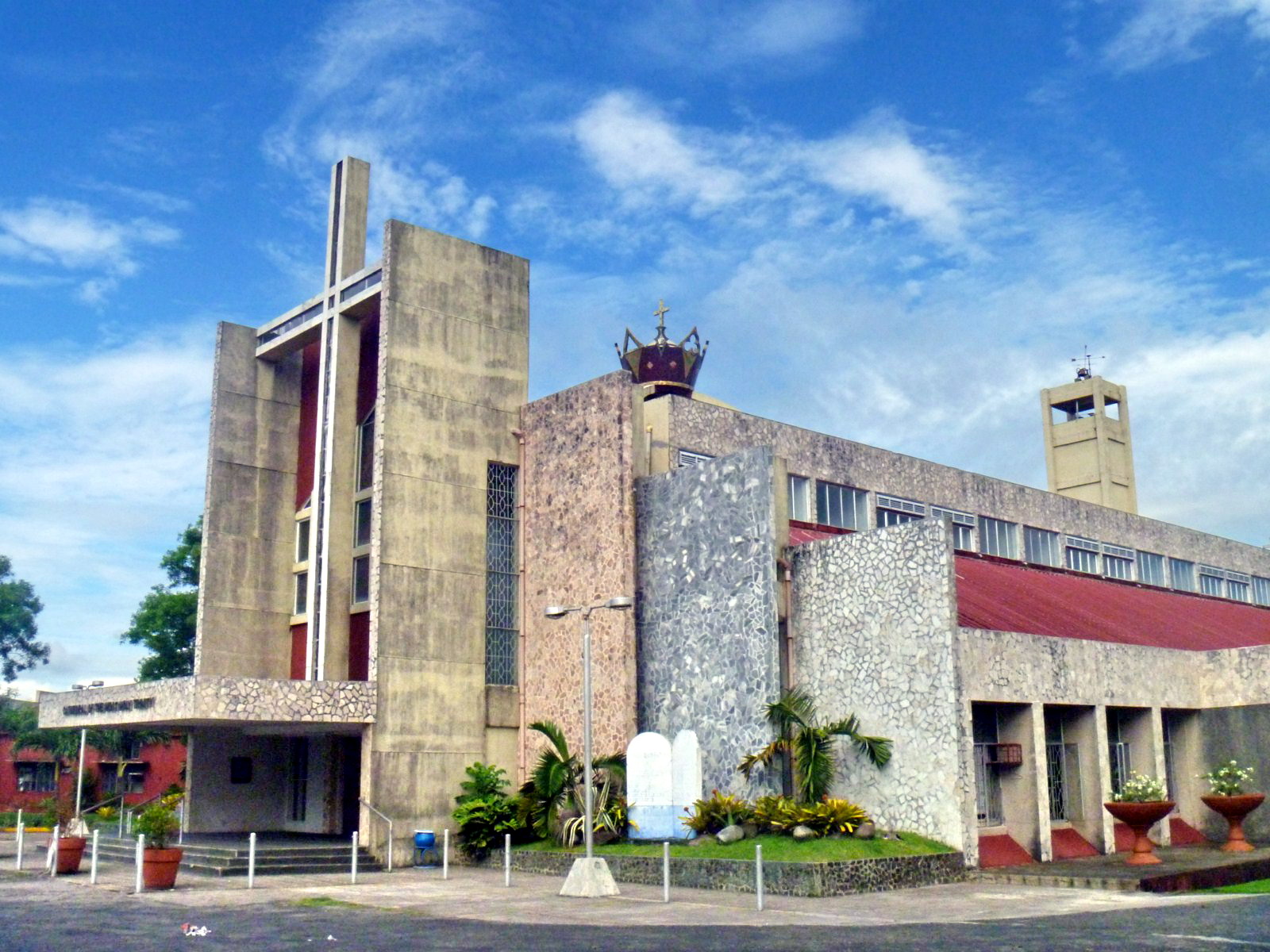
Cathedral of the Most Holy Trinity
Chao Phraya River Cruise (Thailand)
After our Wat Phra Mongkhon Bophit tour in Ayutthaya Historical Park, we all returned to our coach and were all brought to Potangtai Pier near Bangsai (the royal folk arts and handicrafts center) for the start of our 2.5 hr. Chao Phraya River cruise from Ayutthaya back to Bangkok on board the modern and luxurious cruiser Grand Pearl. From Ayutthaya, we would be passing through Pathumthani and Nonthaburi provinces before arriving in Bangkok.

The Grand Pearl
On board, we were in for a late but delicious buffet lunch of mostly spicy Thai and international cuisine served within the luxurious confines of the cruise boat. All 4 of us sat in a comfortable, u-shaped booth beside a large viewing window.
 Dining, Buffet-Style, on Thai Cuisine
Throughout our lunch, we watched the scenery along the banks Chao Phraya River banks within the refreshing airconditioned cabin lounge. By 3:30 PM, midway through our cruise, a refreshing beverage of tea or coffee and cookies were also served to the guests.
 The Airconditioned Cabin Lounge
After our filling lunch, some guests proceeded to lounge at the wooden sun deck at the front of the cruiser while the majority, including us, opted to remain in airconditioned comfort at the cabin lounge.
 The Sun Deck of the Grand Pearl
Sometimes, I would also go up the sun deck, amidst the fresh cool tropical air and warm, afternoon sun, to get an amazingly clearer view of the life of the inhabitants that dwell along the river and the unforgettable scenery of children as they greet the visitors going by.
 Houses Mounted on Stilts
We would watch various kinds of river craft, from barges, smaller wooden pleasure cruise boats to traditional, long-tail boats, their engines invariably mounted on an inboard, turret-like pole which can rotate through 180 degrees, allowing steering by thrust vectoring.
 Long-Tail Boats
The architectural scenery also varies; from simple houses on stilts to modern villas, to modern medium-rise (Mandarin Oriental Hotel) and high-rise (The Peninsula Bangkok) hotels, from traditional Thai temples (the graceful Wat Arun, Wat Kanlayanamit, Wat Rakang Khosittaram, Wat Pathum Khongkha) to old Roman Catholic churches (Church of the Holy Cross) and from magnificent palaces (Grand Palace, Bang Khunprom Palace, etc.) to engineering marvels (King Rama VIII Bridge).
 Royal Barge Museum
The Royal Barge Museum, on the banks of the Bangkok Noi Canal , is a huge boathouse that displays 8 finely-crafted Thai royal barges (including 4 for the king). The majestic Suphannahongsa (“golden swan,” the personal barge of the King, carved out of a single teak tree trunk, was completed in 1911.

King Rama VIII Bridge
The asymmetrical, cable-stayed, 2.45 km. long (including approach spans) Rama VII Bridge, opened on September 20, 2002, has a single, inverted Y-shaped tower, a sleek superstructure and gold-colored suspension cables arranged on single and double planes.
")
Bang Khun Phrom Palace (Bank of Thailand Museum)
The Baroque cum Art Nouveau Bang Khun Phrom Palace, the former residence (until 1932) of HRH Prince Paribatra Sukhumbhand, the 33rd son of King Chulalongkorn (Rama V), now houses the Bank of Thailand (BOT) Museum. The museum has 14 rooms many of which display the history of Thai currency and the Bank of Thailand.

Wat Arun
Wat Arun, recognizable by its central, 66.8 m. high prang (Khmer-style tower) topped with a 7-pronged trident, was started in 1809. It is called the “Temple of the Dawn” because the first light of morning reflects off the surface of the temple with a pearly iridescence. By the side of the river are 6 Chinese-style pavilions made of green granite and containing landing bridges.

Wat Rakang Kosittaram
Wat Rakang Kosittaram (Temple of the Bells), built during the Ayutthaya period, was later reconstructed and upgraded as a Royal Temple by King Taksin. The main features of the temple is the bell tower whose bells gave the name temple the name “Rakang” (Thai for “bell”).

Wat Kalayanamit
The massive, mid-nineteenth century Wat Kalayanamit is well known for its 15.45 m. high and 11.75 m. wide Phra Buddha Trai Rattana Nayok (Luang Po To), called Sum Po Hud Kong in Chinese, which is Bangkok’s biggest Buddha image.
")
Sunanthalai Building (Royal Seminary)
The elegant, century-old Neo-Classical Sunanthalai Building, within the compound of Rajini School (the first girl’s school operated by Thais, founded by Queen Saowapa), was built by King Rama V in memory of Queen Sunantha Kumariratana who drowned in the Chao Phraya River on May 31, 1880. It was restored after a fire in 2005.

Church of the Holy Cross
Nestled among old houses on the river banks and newer buildings inland, recognizable by its reddish dome, is the Church of the Holy Cross (Santa Cruz Church), one of Bangkok’s many old Catholic churches. First built in wood in 1770 during the reign of King Taksin (1867–1782), it was rebuilt in 1835. The present church, built in 1916, was designed by Italian architects Annibale Rigotti and Mario Tamagno.

River City Shopping Complex
Other sights along the river include Thammasart University (Tha Prachan Center), Pom Pra Athit, and the Holy Rosary Church (the oldest Catholic Church in Thailand, also known as Wat Kalawar). Our cruise ended when we docked at the River City Shopping Complex Pier, Si Phraya in Bangkok by 5 PM. Altogether, it was a worthwhile experience.
Grand Pearl Cruises: 19/394 Chaovalitr Village, Rimklong Bangkor Rd., Chomthong, Bangkok, Thailand. Tel: 084-1361199 and 081-9005429.