After our interview of AGAP-Bulusan, Inc. president Philip G. Bartilet at Lake Bulusan, Philip accompanied Bernard and I to the Bulusan municipal hall where we made a courtesy call on, and had lunch, with Mayor Michael G. Guysayko. Like Philip, first term Mayor Guysayko is supportive of the environment conservation projects of AGAP-Bulusan, the rehabilitation of denuded forests and sustainable eco-tourism in the BVNP.
.JPG) |
| L-R: the author, Mayor Guysayko and Bernard |
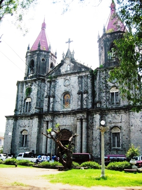
After lunch, Philip again accompanied us as we toured Bulusan town’s tourist attractions. Our first stop was the town’s Church of St. James the Greater in Brgy. Central. Located on a site called Punta Diamante (named after its diamond-shaped wall formation), it is dubbed the “Intramuros of Bulusan.” Its walls were made of stacked up volcanic stones.
.JPG) |
| Punta Diamante |
The church wasn’t old (erected around 1760, its Baroque facade was totally renovated in 1970) but the parish compound is enclosed by ramparts of the triangular, Spanish-era muralla (“stone fort”). Around the walls are burial niches and niches for santos (“saints“) while at one end is the equestrian statue of St. James the Greater and a wooden cross, above which is the statue of a standing Jesus Christ, with arms outstretched, on a pedestal.
.JPG) |
| A baluarte de piedra at Punta Diamante beside burial niches |
Four baluartes de piedra (stone watchtowers”) can still be traced from the remaining walls near the shores of Brgys. Central, Dapdap and Mabuhay. The church’s 4-storey bell tower (locally called kampanaryo), the largest of the 4 watchtowers, was believed to have been built in 1631 after the town was made an independent from Casiguran in 1630. With 8 sides, the tower’s walls taper upwards in alternating piers. The ill-conceived 4th storey, housing the bells, is a totally inappropriate modern addition.
.JPG) |
| The church bell tower |
From the town proper, we motored, 1 km. out of the town, along the Bulusan-Barcelona Rd., to the white sand Dancalan Beach in Brgy. Dancalan. A popular swimming spot, the relatively shallow Dancalan Beach is lined with beach resorts and kiosks beneath the coconut trees that provide shade for picnickers.
.JPG) |
| The white sand Dancalan Beach |
We also passed by the Dr. Jose Reyes Ancestral House and, from the vantage point of a bridge, the Bulusan River. The 12 km. river, formed by the merging of the Dulipay and Malinang Rivers, and the Malugoy-lugoy Rivers, is a potential nature trekking area. From here, we proceeded on our way to Lake Bulusan where Bernard and I were to do some leisurely kayaking.
.JPG) |
| The Bulusan River |
.JPG)
.JPG)
.JPG)
.JPG)


.jpg)