The Idjangs of Batanes

Thousands of years before Spanish colonization, about a thousand pre-Hispanic Ivatans utilized the strategic high ground, living in villages on fortified cliffs and hilltops scattered across today’s Uyugan. These fortified settlements near rocky natural fortresses were called idjangs, derived from the Ivatan word idi or idian, which means “home” or “hometown.” Much of what is known now about idjangs, only initiated in the 1990s, comes from the oral tradition of Ivatans.  These were compiled by native Ivatan Dr. Florentino Hornedo of UST, leading historian on anything relating to Batanes.

These castle-like structures, on elevated rock formations, resemble the gusuku castles of Okinawa (Japan) and some stone-terraced formations in Taiwan.   Pre-Hispanic Ivatans lived in communities of small clans.  During tribal wars for possessions or territory, the clans would climb the idjangs when attacked and throw stones down upon their attackers.
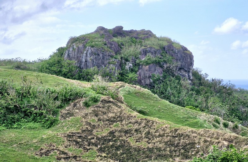
The idjang of Basco

There are 17 of these remnants of stone fortresses on large stone outcrops.  They are located at Brgy. Savidug (Sabtang), Itbayat, Ivana, Mahatao, Brgy. Itbud and Chapidan in Uyugan, Basco and Ivuhos Island (Chuhangin) and Adekey Island off Sabtang.  Artifacts found here include stone tools and implements, earthenware beads, pottery, glass, Chinese ceramics, and human and animal bones. boat-shaped burial markers.

Geologists surmise that the idjang in Basco is molten magma from Mt.  Iraya that cooled off to form a plug for an extinct volcanic crater.  The idjang in Brgy. Itbud (Uyugan) is located at a promontory at the southern end of a beach.
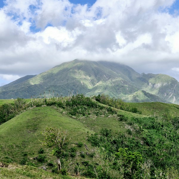
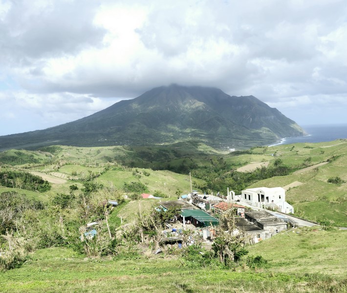
Mt. Iraya

Ancient limestone columns, with holes drilled at one end, are found littered on the idjang slopes.  They may have served as king posts for dwellings or may have once held down cogon dwellings against strong, battering winds.  Some have been recycled as posts for stone houses on Batan Island.  A wall at the idjang’s base (where a creek forks), was made with stones piled on top of each other.  Instead of mortar, they are just held together by pressure from the adjacent stones.

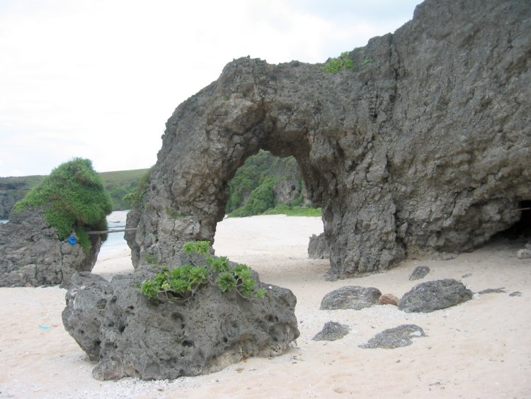
The Chuhangin idjang, in Ivuhos Island (Sabtang), is located on a ledge overlooking the sea and the island’s famed burial grounds.  This idjang is the only one whose sides were built by the ancient Ivatans with stones placed on top of the other without the use of mortar. The Nahini Votox idjang of Itbayat Island has a spectacular view of Dinem and the island’s eastern coast.

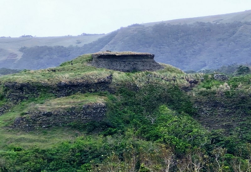
The idjang of Brgy. Savidug in Sabtang

The picturesque Savidug idjang, considered to be the most beautiful and perfectly shaped among the idjangs, appears to have been terraced by human hands to assume a castle-like formation. It is distinctly different from all the others in the province because its sides were carved to make entry more difficult.

Here, archaeologists have recovered, from different levels of the site, various earthenware shards, remains of wild boar and deer teeth, glass beads, shell, coral and bone fragments and some 12th century Sung type greenware.

Savidug Idjang: Brgy. Savidug, 3904 Sabtang.

PAGASA Radar Station (Basco, Batanes)

PAGASA Radar Station

After our tour of Our Lady of Mt. Carmel Chapel, we again boarded our van for short drive, uphill, to the PAGASA Radar Station, also known as Radar Tukon.  This radar station, located on a hilltop about 300 m. above sea level, is the northernmost weather station of PAGASA (Philippine Atmospheric Geophysical and Astronomical Services Administration).

Check out “Our Lady of Mt. Carmel Chapel

Formerly a site of a lighthouse and an abandoned pre-war hilltop U.S. weather station, it monitors typhoons that enter and leave the country’s area of responsibility.  However, its huge satellite disk was ripped off by gale-force winds during September 13, 2016 super typhoon Ferdie (international name: Meranti) even before it was put to effective use.


From its top, we had a magnificent and breathtaking 360-degree view of Batan Island, the West Philippine Sea, the boulder-lined cliffs, Mt. Iraya, rolling hills and the magnificent pastoral beauty of labyrinth-like hedgerows (liveng) and fields on one side and the Pacific Ocean on the other side.

Mt. Iraya

Hedgerows (liveng)

On a clear day, you can see Dinem Island in the distance and, behind it, the faint silhouette of Itbayat Island,

Our Lady of Mt. Carmel Chapel (Tukon Chapel)

Ukuy’s Place, in the foreground, and Fundacion Pacita, in the background

PAGASA Radar Station: Sitio Tukon, Brgy. Chanarian, 3900 Basco.

How to Get There: From Basco it’s a a 2.75-km. (1.5-hour) hike, a tough 30-minute bike ride or an easy tricycle jaunt up to the Radar Station.  It is also a short 5-min. walk to Our Lady of Mt. Carmel Chapel (Tukon Chapel)

Our Lady of Mt. Carmel Chapel (Basco, Batanes)

Our Lady of Mt. Carmel Chapel (Tukon Chapel)

After checking in and having a breakfast of fried dibang (flying fish) with pako salad, fried egg and rice at Bernardo’s Lantia Hotel, we were all picked, at 12 noon, by our guide Harvey Gutierrez for our North Batan Tour on board a Toyota van of A.A.B. Travel and Tours.

Check out “Hotel and Inn Review: Bernardo’s Lantia Hotel”

Harbour Cafe

A short 2.3 km. (5-min.) drive brought us to Harbour Café where we had lunch before starting our tour.  The café has a good view of Basco Port.

After lunch, we again boarded our van for another short, 2.9-km. (7-min.) drive to Our Lady of Mt. Carmel Chapel.  Parking along the road, we climbed a short flight of steps to get to the chapel.

Grace and Jandy

Also known as Tukon (tukon means “mountain” in the Ivatan dialect) Chapel, this project of the late Henedina “Dina” R. Abad (former Batanes Congresswoman) and her husband Florencio “Butch” B. Abad (former Department of Education Secretary) was built to help Tukon’s residents, especially the older ones, avoid the long walk to Basco to attend church services.

Interior of the chapel

Adopting the design of a traditional Ivatan house (stacking and bonding boulders to make a wall), local craftsmen, masons and carpenters built the church and it is the only chapel embodying such design.

Continue Reading →

Country Nook (Basco, Batanes)

Country Nook

On the day prior to my departure, I was invited to joined a picnic at Country Nook hosted by youthful Basco Mayor Manuel Viola, again feasting on true Ivatan seafood fare.  Country Nook had a couple of magnificent rock formations just offshore.  Joining us was Ms. Carol Pobre (of DOT Region II) and Francis “Chico” Domingo, a certified PADI divemaster and A.D.S. instructor.  They were to dive deeper portions of Batanes’ marine environment which is rich with marine resources.  Batanes is one of the few remaining sites where pink and red corals (Corallum sp.), some of the rarest sea corals in the world, are found.  Chico has a vast knowledge of the province’s dive sites.

Carol and Chico take a dive

I could only watch in envy as Carol, accompanied by Chico, explored the offshore marine sanctuary’s beautiful underwater scenery and marine life.  I was offered and wanted to join them but, according to Chico, diving wasn’t allowed 12 hours prior to my flight (I was leaving 8 AM the next day).  Carol was leaving a day after my departure.  However, my disappointment was later dispelled by a beautiful Batanes sunset. 

A beautiful Batanes sunset. Carol is in the foreground

Country Nook: Sitio Vavayat, Brgy. Chanarian, Basco, Batanes

Church of Sto. Domingo de Basco (Batanes)

Come Saturday late afternoon, I decided to attended mass at the lovely Church of Sto. Domingo de Basco, the oldest in Batanes.  The church was just walking distance from the inn I was staying in. The mass was held in the unique Ivatan dialect.

Church of Sto. Domingo de Basco

First built from 1787 to 1796 (one of the first limestone buildings to be built under the Spanish regime), it was destroyed during a typhoon and rebuilt in 1812 by Dominican friars. Its façade fell to the ground during the 2000 earthquake.  The present white Baroque church, built in the espadaña style, has massive pilasters buttressing the thick walls from foundation to top.  It incorporates the original front and north walls while the rear and south walls are inside the original ruins.  The convent beside the church was built in 1814.

The church interior

Morong Beach (Sabtang, Batanes)

After that filling and unique lunch, I found out that I still had time to spare before taking the last falowa back to the mainland, so I decided to make a quick visit to Brgy. Sumnanga.  Inaccessible by the Toyota Revo, I hired the services of Mr. Alex Habana, hitching on his motorcycle to get there.  I had no time to explore, on a walking tour, the barangay proper, a portion of which used to be called “Little Hongkong” because of the cobblestones that used to cover its pathways.

Morong Beach and Ahaw Arch

I, however, visited the white sand Morong Beach (often mistakenly called Nakabuang Beach), with its sea-sculpted cave and its landmark Ahaw Rock Arch.  A number of tourists were swimming along the beach but I didn’t have the luxury of time so I made my way back, dropping by the new lighthouse along the way for some photo ops.  We arrived at the port in time for last (4 PM) boat trip back to Ivana.

Sabtang’s lighthouse

A Unique Ivatan Feast (Batanes)

Back at the town proper, I was invited by Mayor Caballero to join Gov. Gato, Cong. Abad and his other esteemed guests in a true Ivatan feast at the municipal hall.  The Ivatan fare spread before us, though simple, was hearty, filling, ingenious and nutritious, using  ingredients that are rich and unusual. Its taste and texture distinguishes it from the country’s other regional cuisines.

Spiny lobster (payi)

The prepared fare consisted spiny lobster (locally called payi, here I got it at just PhP250/kilo), tasty steamed coconut crabs (tatus), flying fish (dibang, plentiful from January to June), Spanish mackerel (tanigi) and the local meatball dish called tabtab (called uvud in Mahatao).

Uved

Uved, a staple food in every Ivatan’s dining table, is a mixture of the minced or finely grated core of the banana stalk pith (the big rhizome), ground pork or beef, minced bits of deboned dibang or tanigi, sweet potatoes, ube, some pig’s blood and other rootcrops, seasoned with local herbs, garlic, onions salt and pepper, molded into small balls, steamed and then served with a salad of tomato, onions and seaweed. 

Yellow rice on kab”baya leaf

Instead of the usual white rice, we were served fragrant, delicious supasvery sticky cooked yellow rice colored and flavored with and extract of yellow ginger or turmeric (locally called nihaman). Instead of plates, we ate this unique fare on the green leaves of a local breadfruit tree called kab’baya

A Tour Around Sabtang (Batanes)

Church of St. Vincent Ferrer

Once through with the blessing, Mayor Caballero allowed me the use of the municipality’s Toyota Revo plus the services of driver Rolando Fidel, to tour the island’s many sights.  Before leaving, I dropped by the St. Vincent Ferrer Church, a relic of the island’s tumultuous Spanish past. Started in 1844, this church was built in the espadana style (having two round arches at the roof level for the bells).

The Savigug idjang

Along the road to Savidug, Mr. Fidel pointed out, from a distance, a picturesque idjang, a pre-Hispanic mountain fortress where the natives sought refuge during tribal conflicts.  This idjang is distinctly different from all the others in the province because its sides were carved to make entry more difficult.

Chavayan village

Upon reaching the showcase barangay of Savidug, our Revo had to negotiate a narrow road between rows of traditional lime and stone cogon thatched houses.  Alighting here, I explored the village on foot, espying one of the barangay’s two (there are only three left throughout Batanes) animal-driven sugar mills that churn out a native wine called palek.

A carabao-driven sugar squeezer

A scenic, winding road next leads us to the equally rustic village of Chavayan and its landmark Chapel of Sta. Rosa de Lima, the only house of worship on the islands that is still in its traditional form.   The southernmost community in the province, Chavayan faces the northern tip of Luzon Island. Here, I observed, on another walking tour, the traditional detached Ivatan kitchen as well as glimpses of the Ivatan way of life including the making of the vakul or canayi.  

An Ivatan woman wearing a vakul

Serving as protection from the scorching heat of the sun or the wind and rain, these are woven by the womenfolk from carefully stripped and dried banana or voyavoy leaves. I also observed, up close, 99-year old Ireneo Hornedo weave an alogong, a men’s headgear that normally goes along with the canayi.  Before leaving, we were requested to looking up into the cliff and make out Mother Nature’s most perfect sculpture; the phallic-looking Monument of Satisfaction.

Irineo Hornedo (left)

A Sabtang Welcome (Batanes)

The third day of my 5-day stay in Batanes was reserved for a visit to the 40.67 sq. km., beautiful, mountainous and extremely rugged Sabtang Island.  According to a coffee table book published by the DOT in 1994, Sabtang Island was chosen as one of the 12 best destinations in the country.  I wondered why.  Having left Mama Lily’s Inn very early in the morning, I was able to hitch a ride, via Batanes Gov. Vicente Gato’s van, to Radiwan Port in Ivana, the gateway to the island.   I was to travel with distinguished company.  Joining me in the falowa (a round-bottomed boat) for the nearly 1-hr., 5-km. and fairly rough crossing across the Ivana Channel was Gov. Gato himself and Congresswoman Henedina Razon-Abad (wife or former Education Secretary and Congressman Florencio “Butch” Abad), both inaugurating a school library on the island, plus guests Ms. Carol Pobre and Ms. Bing Talla, both of DOT Region II, and Ms. Margarita Garcia, a Fil-American Fullbright scholar teaching art to Ivatan schoolchildren (I later found out she was living at the lighthouse at Naidi Hills in Basco).

The scenic, winding road to Chavayan

Sabtang’s beautiful shoreline is similar to Batan Island, having intermittent white sand beaches, deep canyons, sand dunes that rise up to a hundred feet and steep, 200 to 350-m. high mountains that run down the island’s spine, making the island slope outward to the coast.  Small level areas are sporadically found along the northeast coastline and mountains have to be terraced to accommodate communities.   The only town, the picturesque Sabtang (also called Centro or San Vicente), is located on the island’s eastern seaboard.  The waters around the islands are said to have one of the richest fishing grounds in all of Batanes.

Church of St. Vincent Ferrer

It seems one half of the island’s 1,678 Isabtang population came out to greet our party upon our arrival.  I, however, mistook the town’s parish priest for the mayor but soon corrected myself and paid my respects to the boyish-looking Mayor Juan “Johnny Caballero, smartly attired in a Hawaiian-style polo shirt. The blessing soon got underway.  

Uyugan and Back (Batanes)

Songsong Ruins
Old LORAN Station

Entering Uyugan, we passed by the old LORAN (Long Range Aid to Navigation) Station, in Alapad Point in Brgy. Imnajbu and the ruins of Songsong, a cluster of roofless old stone houses of a once thriving community of fishermen that was abandoned in 1955 after the inhabitants experienced severe famine as a consequence of the strong typhoons and tsunami in 1953 and 1954. The villagers resettled to Maramag, Bukidnon. Some of the ruins are now being restored while others are already inhabited.

Entry to Dipnaysujuan Tunnels

Along the Vajangshin Road, we passed by one of the 5 openings of the the Dipnaysujuan Tunnels, an abandoned Japanese-built World War II network of 8-ft. high and 6-ft. wide bat-filled tunnels. Too bad, we didn’t have kerosene lamps or flashlights to explore the dark tunnels.  Finally, on the way back to Basco, we also passed by an idjang (one of 17 throughout the province), a rocky castle-like natural fortress where pre-Hispanic Ivatans lived.

Basco idjang