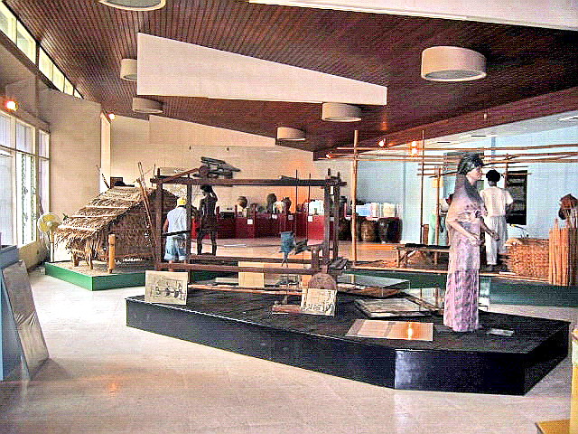
Church of St. Joseph the Patriarch (Aguilar, Pangasinan)

This fine old Spanish-era church was first built in 1809 by Dominican Father Bernardo Pons.  The foundation of the present church and bell tower were first laid by Fr. Benito Sanchez Fraga, continued by Frs. Ramon Dalmau and Francisco Treserra and finished by Fr. Pedro Villanova.  It was inaugurated on June 4, 1854.  The choir loft and sacristy were built by Fr. Lucio Asensio.  From 1866 to 1878, Fr. Gallego built the main altar and ceiling, painted the church and finished the bell tower.   The bell tower was destroyed during the March 16, 1892 earthquake and later repaired by Fr. Victor Herrero.

Church of St. Joseph the Patriarch

Church of St. Joseph the Patriarch

The church has a distinct 3-level Baroque facade with a large volute at the pediment sloping down to the second level.  There are also superpositioned columns, a segmented arched main entrance, depressed segmented arched windows on the second level and a statued niche at the third level.   The foundations of its present convent was first laid in 1832 by Fr. Juan Alvarez del Manzano, continued by Fr. Nicolas Fuentes and finished by Fr. Benito Sanchez Fraga.

The church interior

The church interior

How to Get There: San Fabian is located 9 kms. south of Lingayen and 191 kms. from Manila.

Governor’s Island (Hundred Islands, Alaminos City, Pangasinan)

From Martha Island, our boatmen brought us over to Governor’s Island for a brief stopover, One of 3 developed islands in this mini-archipelago (the others are Quezon Island and Children’s Island), it has a governor’s guesthouse with 2 bedrooms for 6-8 people, living room, dining room, toilet and bath, kitchen (with dining and cooking utensils provided for), ceiling fans and generator lighting.  It also has 2-pax nipa huts and camping is also allowed here.  
 
The viewpoint of Governor’s Island
There are white sand beaches on both sides of the island.  From the beach, we a short hike up some carved steps that lead to the island highest point.  At this viewpoint, we had an  unobstructed panoramic view of the many granite and scrub-covered islands that compose this national park.  After some photo ops, we made our way back down the hill.  Back at our boat, we were finally brought back to Lucap Wharf.  After paying our boatmen, we had our first freshwater shower at the complex, loaded our gear at our car, had lunch and proceeded on our way to Bolinao.

Cathedral of St. Joseph (Alaminos City, Pangasinan)

This church was first built by in 1770 but was destroyed by fire in 1814.  The present structure was started by Fr. Manuel Busqueto from 1837 to 1849 and continued by Fr.Jose Tornos from 1849 to 1878.  Fr.Victorino Vereciano renovated the roof and the floor from 1879 to 1893.

Cathedral of St. Joseph

Cathedral of St. Joseph

The church has a plain and simple, three-level Baroque facade.  The third level has a wing-like, undulating wall concealing the aisle roof.  It also has segmented arch main entrance with similar segmented arch windows at the second and third level.

The cathedral interior

The cathedral interior

How to Get There: Alaminos City is located 334 kms. from Manila and 42.5 kms. northwest of Lingayen.

Martha Island (Hundred Islands, Alaminos City, Pangasinan)

The sun was already low in the sky when we packed our tent and belongings and again boarded our boat to take us to nearby Martha Island.  We thought we had the island to ourselves as the white sand beach, connecting the two islands, was deserted.  Once on dry land, our boatmen left us, promising to return the next morning to pick us up.  We were soon setting up our tent and was  just about done doing this when boats, one after the other, began unloading local tourists, with the same mindset as ours, on our tiny strip of beach.  I guess there’s simply no escaping the maddening crowd.  

Martha Island

It was too dark to go swimming, so we just settled down in our tents, ate our packed dinner and spent the rest of the night playing cards.  Jandy and the others slept inside the tent while I slept outside, on my rubber mat.  I thought I came fully prepared for camping but I forgot one essential item – Off Lotion. There were no mosquitoes around.  Instead, what bothered me during my sleep were nasty sandflies (locally called niknik).  The ground I was sleeping on was also lumpy.  Sleep didn’t come easy to me that night, if at all.   

Relaxing under the shade
The island’s beach

Come morning, we prepared our breakfast of coffee and sandwiches.  Luckily for us, the rocky outcrop beside our tent shaded us from the morning sun.   Right after breakfast, we donned our swimming attire to go swimming.  The waters by the shoreline wasn’t as clear or as inviting nor its slope as gradual as the beach in Romulo Island.  Poor visibility meant no snorkeling.   Still we made do with what was before us.  Our boatmen arrived earlier than expected, so we packed up our tent and belongings and boarded our boat.  

Romulo Island (Hundred Islands, Alaminos City, Pangasinan)

Come morning, we checked out at Texas Inn and proceeded to Brgy. Lucap, the gateway to the Hundred Islands National Park.  The port was already packed with local and foreign tourists, it being the Holy Week break.  Our plan was to go island hopping and then stay overnight at one of the islands.  Just a few days earlier, on March 19, the management of the Hundred Islands  was turned over by the Philippine Tourism Authority (PTA) to the Alaminos City government. 

Hundred islands National Park

Before, anything else, we had lunch at the port and then decided on what to bring (camping equipment, swimming attire, sleeping bags, packed food, etc.), leaving the rest of our stuff inside our parked car.We then negotiated with some boatmen for a motorized boat to take us island hopping and settled on the price of PhP1,200.  Lastly, we had to choose from 127 islands and islets that make up this 1,844-hectare national park.  As we prefer beaches, choosing was easy as most of the islands are granite and scrub-covered and heavily-undercut at the base.  Only a number have sandy beaches.

On our way

The plan was to go first to Romulo Island, where we can go swimming, then  transfer to Martha Island where we were to stay overnight.  We left the port on our chartered motorized boat a little past 2 PM and soon made landfall at Romulo Island by 3 PM.  The island was packed with tourists sheltering on what little shade they can get on the island, mostly low shrubs and the undercut bases of the island.   We came prepared for this eventuality, setting up my tent on the white sand.  Our tent provided privacy as we changed into our swimming attire.  

Romulo Island.  Ours is the only tent on the beach
Vi beside our tent
A suited up Lulu ready for a swim

The island’s clear water was simply pristine and slope gradual.   Just across, Braganza Island seemed so near but experience told me that the short distance can be deceiving.  Besides, the current between the islands is notoriously strong.  Instead, we just lazed the afternoon away by swimming or snorkeling. Too bad, it wasn’t low tide yet.  A cave on the other side of the island is exposed and approachable during this time.

On the Road to Alaminos City

Come Holy Week, I decided to bring Jandy to the Hundred Islands in Alaminos City as well as Bolinao, both in Pangasinan, a first for both of us.  For companions, I invited friends Lourdes “Lulu” Siguenza and Rosevie “Vi” Sevilla, also both first-timers to these destinations.  Bringing along my 2003 Toyota Revo as well as camping equipment (tent, portable stove, sleeping bags, portable lamps, etc.), we departed Manila by 6 PM and, somehow, avoided heavy traffic, it being the holiday rush, and being stopped for number coding violations (we weren’t  sure if this was suspended)

Vi and Lulu at Texas Inn

At the North Luzon Expressway (NLEX), we made a short stopover for dinner at a Chowking outlet in Petron Marilao (Bulacan) then continued on our way.   It seems I took the wrong exit at NLEX as I found out, much later, that I was headed for Zambales instead.  As a result, we lost valuable time, and gasoline, as we backtracked and entered the proper NLEX exit at Dau.  From there, we passed through Tarlac City and Camiling, then entered Pangasinan, way past midnight, at Mangatarem.  We then passed through the towns of Bugallon, Labrador and Sual before entering Alaminos City, arriving there by 1:30 PM.  Being very late, we decided to get some sleep at the first inn we could find – Texas Inn which, I found out soon enough, was a drive-in motel.  I was too tired to care.  

Church of St. Joseph (Las Pinas City)

Church of St. Joseph (left) and the old Spanish convent (right)

While driving along the Alabang-Zapote Rd. in Las Pinas City with Jandy, I decided, on a whim, to revisit the Church of St. Joseph.   The church was built by Fr. Diego Cera de la Virgen del Carmen, parish priest of Las Piñas till May 15, 1832 (when he could no longer perform his duties due to severe illness) between 1792 and 1818, to replace an earlier structure of bamboo and nipa.

Facade of Church of St. Joseph

This labor of love, built with adobe stones in the “Earthquake Baroque” style was, however damaged during the 1829 (January 18, July 29 and September 30), 1863 (3 June) and 1880 (19 July) earthquakes and rebuilt again in 1883.

The statue of Fr. Diego Cera sculpted by Napoleon Abueva

The church façade and its grounds were effectively renovated, from 1971 to 1975, using the services of noted architects Francisco “Bobby” Mañosa and Ludwig Alvarez.

Historical plaque installed by the National Historical Institute (now National Historical Commission) in 1995

The major part of the restoration involved the cleaning of the exterior walls to reveal the original walls and the missing stones were replaced with similar stones to limit the use of cement.

The bell tower on the church’s left

On December 3, 1972, the new church was inaugurated.with a slightly advance middle section and a semicircular arched main entrance topped by a depressed three-centered arch. Semicircular arched windows and jambs with fluted piers flanked both. It is 34 m. (110 ft.) long, 29 m. (94 ft.) wide and has a nave width of 21 m. (70 ft.).

The church’s interior

On its left is the massive, 4-storey high square bell tower while on the right is the old Spanish convent (it now serves as an entrance).  Inside the church are stained capiz windows, narra pews, a bamboo ceiling and carriage lamps on bamboo stands.

The church’s main altar which was repositioned, during the 1971 to 1975 restoration, to face the people as required by the new Ecumenical Council guidelines

Within the church compound is a statue of Fr. Diego Cera, sculpted by National Artist for Sculpture Napoleon Abueva, and unveiled on July 27, 1995, the 200th anniversary of the Parish of St. Joseph.

Bamboo Organ

Also called the Bamboo Organ church, it houses the Bamboo Organ, a pipe organ made mostly with bamboo pipes.

Check out “Bamboo Organ

A side altar


NOTE: On July 15, 2013, the Church of St. Joseph was declared as a National Historic Landmark by National Historical Institute.

The original hewn stone baptismal font, discovered buried in the courtyard of the church, was cleaned by the late notable sculptor Eduardo Castrillo who also added a brass basin sculpture as his additional contribution.

The old, hewn stone baptismal font with the brass basin sculpture added by Eduardo Castrillo

Church of St. Joseph: P. Diego Cera Ave., Brgy. Daniel Fajardo, Poblacion, Las Pinas City, Metro Manila.  Tel: (632) 8820-5454, 8825-7190 and 8820-0795.

Mystical Mt. Makiling (Los Banos, Laguna)

It was field trip time for my daughter Cheska’s Colegio San Agustin class and Lakbay Kalikasan, Southeast Asia’s first and premier outbound education outfitter, was tasked to organize it.    Mt. Makiling was the selected destination.  Upon invitation by Mr. Ramon Jocson, Lakbay’s Corps Director, I decided to tag along.

Mt. Makiling
This 1,090-m. high, 3-peaked mountain, located 65 kms. southeast of Manila, is, owing to its natural history, the most biologically well-known of Philippine mountain and a favorite for field trips.  The slopes of the mountain form a 4,244-hectare national park covering portions of Bay, Calamba City and Los Baños; all in Laguna, and Sto. Tomas in Batangas.  These places depend on the watershed of the mountain for their domestic water requirements and irrigation while Los Baños’ and Calamba’s resorts and tourism industries depend on it for their hot springs.


Most field trips, including this one, enter via U.P. Los Baños (UPLB) which is halfway up the summit.  The mountain is also accessible from Alaminos (Laguna) and, for the extreme adventurer, from the more difficult and barely passable (due to the thick jungle) Sto. Tomas route, on the other side of the mountain.   Makiling is said to be the legendary home of the beautiful local goddess, Mariang Makiling.

According to folklore, she was the beautiful young daughter of two deities: Dayang Makiling and Gat Panahon.  Half goddess, half spirit of the air, she was tall, svelte, sweet, with big black tantalizing eyes, long, black, abundant hair reaching to her ankles, pure brown skin, and enchanting smile and a captivating, melodic voice.  She was born of the rays of the moon and lived in the beautiful mountain, roaming the forest and protecting its wild boars and other animals.

Visible to, and loved and respected by the townspeople, she had a generous heart, scattering golden ginger in the yards of every house in her domain and never turning down a request for help or assistance.  She rewarded hunters, who, at her request, spared the animals.

Her kindness, sympathy and acts of benevolence were often forgotten and disregarded by the people.  To punish them, she denied permission to pick fruits in the forest and prohibited hunting of wild animals. For those who disobeyed, she would cause the sky to grow dark and the heavy rain to fall.  To hunters, she assumes a frightful form and sends them to their death.  She fell in love with a mortal man who proposed to her but backed out before their wedding day and later married a mortal woman.  Despondent, she disappeared into the forest and was never seen again.  Her presence, however, is still felt as she continues to watch over the mountain’s natural bounty.

Makiling is one of the few mountains in Luzon that still has some primary forests.  It originally had lowland dipterocarp forests up to the 600 m. mark but the western and southern flanks are now denuded due to kaingin (slash and burn) farming and logging while the eastern slopes are covered with coconut, banana, coffee and other crops.  However, exotic lowland type dipterocarp forest trees and orchards have been introduced for reforestation at its lower slope, transforming the forest below 300 m. into a “parang” type of vegetation.  Above 900 m. are some montane forest and, at the summit, a dwarf mossy forest.  Makiling is a dormant volcanic massif but remnants of its north wall crater no longer exist.  However, heat still escapes from it in the form of mud springs and hot sulphur springs.       Makiling is also a field laboratory for many environmental and biological researches in UPLB.   Aside from being a favorite for school field trips, Makiling is also a popular camping and hiking area for Boys and Girls Scouts, as well as other camping enthusiasts.  The 10th World Boy Scout Jamboree was held on the mountain from June 17 to 26, 1959 and camping is still done at the BSP Wood Badge Area.

Camping, however, wasn’t in the field trip agenda.  They were here to learn. This outdoor classroom showcases the rich biodiversity of the country, being home to 2,038 species of vascular flora (85% of Philippine flora spread out in 949 genera, 19 sub-species and 167 varieties), 24 species of mammals (10 families and 19 genera) and 21 species of amphibians (4 families and 8 genera), 10 of which are endemic. Bryoflora includes giant ferns, 34 species of mosses and 42 species of liverworts.   About 60% of all known fungi have also been found here.     Popular with bird watchers, the mountain is home to 163 species of birds (spread out in 110 genera and 16 families).

Museum of Natural History
A repository for all these biological specimens is the Museum of Natural History, located immediately to the left of the archway going into the College of Forestry and Natural Resources. Housed in a former student dormitory of UPLB, here students are awed by its collection of more than 200,000 Philippine plants, animals, microorganisms and other bioda.  Most of the late Prof. Dioscoro Rabor’s priceless collections are also housed here. Its exhibits feature, among others, the Philippine eagle, tamaraw, tarsier; snails in Mt. Makiling and Laguna de Bay; Philippine plants, forests, shells; Philippine cobras, marine turtles and mammals; and a Philippine map made of 4,012 locusts and lahar from Mt. Pinatubo. A visit here is the piece de resistance for any Makiling field trip.

Rappelling at Wawa Gorge (Rodriguez, Rizal)

Wawa Gorge

I again joined as a guest in a demonstration tour hosted by Lakbay Kalikasan for teacher representatives from 9 different schools, this time to Montalban (now renamed Rodriguez after its late local son and Senate president Sen. Eulogio “Amang” Rodriguez, Sr.), a town steep in mystery and folk legends, and one of the nearest, it being just 28.60 kms. from Manila.  Assembly and pick-up point was our usual EDSA Shrine.  Our 2-van convoy made a brief stopover at U.P. Diliman (my college alma mater) before proceeding to our final destination, the town’s Wawa Dam and its beautiful gorge.

The two mountains of Bernardo Carpio

Montalban is mostly mountainous, its central and eastern sections being traversed by mountain ranges extending north to south.  It also has a series of steep, sloping ridges. The province’s highest peak, the 1,468-m. high Mt. Caladang, is located along the Rodriguez/Quezon province boundary.  The town’s mountains and caves figured prominently during the early days of the Katipunan (a hideout and a site for secret meetings) and the Philippine Revolution (site of a June, 14, 1897 rout of Spanish forces under Col. Dujiols).     

Montalban is full of legends and folklore.  Near Wawa Gorge, the folk hero and demigod Bernardo Carpio was said to hold two mountains apart, with his mighty hands, to prevent them from colliding.   His enemy, the enchanted king of the mountains of San Mateo, was defeated by Bernardo in a wrestling match.  The king had his revenge when he enticed Bernardo to enter Pamitinan Cave.

He blocked the entrance, with two gigantic boulders of rocks, and trapped him inside forever, thus shackling him to a prolonged bondage. When an earthquake occurs every 100 years, it is said to be Bernardo breaking one of his chains.  It is said that when all his chains have been broken, he would then liberate all his countrymen from their own slavery.

Wawa Dam

Wawa Dam (also called the Montalban Dam), located at the foothills of the Sierra Madre Mountains, in Brgy. Wawa, supplies water to the Novaliches area in Quezon City.  Overlooked by Mt. Irid, its spectacular, forested Wawa Gorge lies between two marble and limestone mountains (of Bernardo Carpio fame) and, through it, passes the Wawa River (or Marikina River) as it flows into Laguna de Bay.  On our way to the dam, our group espied one of 4 caves believed to be Japanese strongholds during World War II.  A historical marker was said to have been placed at the entrance of one of the caves in memory of the Japanese soldiers who died in the three-month long battle in 1945.  Treasure hunters are also said to be attracted by rumors of gold buried in the caves.

Wawa Gorge is also the place to be for the relatively new, adrenaline-pumping and extreme sport of rock climbing.  The gorge’s 400-meter high cliffs provide different levels of difficulty for rock climbers.  There are ten rock climbing sites with approximately 50 established routes, graded 5.0 to 5.12, all stable, free from vegetation and generally safe from rock falls.   Its Redemption Area, perpendicular to a metal footbridge, features “Fun in the Sun” (unrated), “Redemption” (5.10, bolted), “Sacrament” (5.8, bolted), “Sanctuary” (5.6) and “Under the Bridge” (has three short, unrated climbs).  The strictly traditional “Sanctuary” is the most popular.

Trying my hand at rappelling

We, however, weren’t there for the rock climbing and there was to be no rock-climbing spectacle either on this hot summer day. Lakbay Team Leader Ryan Viado, however, had a special treat in mind for us: the equally adrenaline-pumping sport of rappelling at the gorge’s metal footbridge.  Rappelling, is nothing new to me, having tried (and enjoying) it during a past Lakbay tour of Biak-na-Bato National Park in Bulacan. Assisted by Alan Galang and Alexes Erquiza, Ryan soon had our rappelling equipment installed at the bridge.  Initially, there were no volunteers willing to try this seemingly once-in-a-lifetime experience.  To set a precedent and embolden the others, I took the first crack at it, doing a near-flawless performance. Just like in Biak-na-Bato, rappelling was the piece de resistance for this fruitful and memorable day.

Lakbay Kalikasan: G/F Balai Lakbay, 2 Alondras St., Mira-Nila Homes, Tandang Sora Ave., Quezon City, Metro Manila.  Tel: (632) 932-7818 to 19.  Mobile number: (0917) 500-4796. Website: www.lakbaykalikasan.com.

Ma-cho Temple (City of San Fernando, La Union)

Finally, at the northern edge of the city , I drove my Toyota Revo up a promontory overlooking San Fernando Bay, to the impressive Ma-Cho Temple, said to be the largest Taoist temple outside of China.  Meaning “Heavenly Mother,” this ornate temple is a mélange of both Taoist and Catholic symbolism and decor and has 5 gates.  It was constructed in honor of Ma-cho, a Chinese deity of the Sung Dynasty.  

Ma-cho was born in 960 AD at Meizhou village in the scenic island of Moichow in the province of Fukien in southeastern China.  According to legend, she did not cry during the first month of her infancy.  Thus, she was first named Mo meaning “keeping silent.” Intelligent, she became a monk at the age of 10 and was said to be gifted with healing powers and the ability to predict the weather and sea conditions, even days ahead.  During typhoons, she actively participated in rescue operations for fishermen.  Locals called her the “Dragon Girl,” “Goddess of the Sea” or “Queen of Heaven.”  She died young, at age 27, but even today, local sailors and fishermen believed that her spirit, dressed in red, continues to  watch over and protected them.

Here in the country, Ma-cho is known as the Virgin of Caysasay, patroness of the Filipino-Chinese faithful.  The temple houses a replica of the image, a parting gift of love given by Taiwanese fishermen in 1968.  The distinctive features of the temple were inspirations of Ma-cho through buyong sessions  held every other week.  Here, temple elders read or interpret Ma Cho’s message to the faithful.

Ma-Cho Temple

The temple, designed by Arch. Tomas Diokno, sits on a 9,000-sq. m. lot at an elevation of 70 ft..  Groundbreaking began on September 11, 1975 and actual construction began on December 2, 1976.  The Virgin’s image was enshrined on July 3, 1978 and the temple was finally inaugurated on December 6 that same year.  Devotees believe that Ma Cho and the Virgin of Caysasay are one and the same.  From September 21 to 26, devotees gather for the annual celebration of the image’s enshrinement.  From the Basilica of St. Martin of Tours in Taal, Batangas, the devotees, together with the image of Ma Cho, will travel back to San Fernando City.  Once in the city, it is borne in a procession around the city’s business district, accompanied by the traditional Dragon Dance.  It is then culminated by a cultural presentation.

The temple’s  meditation room

The temple’s entrance wall is adorned with beautifully-carved, imported stone statues of the “Chinese 18 Saints,” in different poses.  Its circular courtyard, made with brick, has a centrally-located pond with water lilies and goldfish.  Beside it is a small structure where one can burn offerings for the gods.  On the other side are statues of animals, believed by the Chinese to be good luck charms.  The temple’s towering arch has a panoramic view of the South China Sea.  The meditation room has a grand staircase and red kneelers.  Ma Cho’s 8″ high wooden image is adorned with a traditional Chinese headdress and richly-colored robe.  Her oriental eyes are closed while her hands are clasped together at her chest. Aside from incense, devotees also offer food and money at the shrine.  Also housed in the sacred temple is Tho Ti Kong (God on Earth) while in another garden stands the statue of Kuan Yi Ma (God of Mercy), another important Chinese deity.

Ma-Cho Temple: Ma-Cho Temple Driveway, Brgy. II, City of San Fernando, La Union.