Mindoro Trail: Batangas City to Mamburao (Mindoro Occidental)

The 10,245-sq. km. Mindoro Island, the country’s fifth largest island, remains relatively unknown in the tourism highway.  Outside of Puerto Galera and what little we know of the traditionally animist, polytheistic and semi-nomadic Mangyan tribe and the rare, severely endangered and elusive Mindoro dwarf water buffalo or tamaraw (the country’s largest wild animal), very few have even heard of it.  More so with Mindoro Occidental, its western part.


Batangas International Port

Yours truly, together with Mr. Harland “Charlie” Kemplin of United Tourist Promotions (makers of EZ Maps), wanted to correct this sad state of affairs by creating a tourist map of the island (featuring Puerto Galera, Calapan City, Mamburao, Sablayan, Pandan Island Resort, etc.), probably the first of its kind to be so conceived.  To do this, we had to experience the island, first-hand, by circumnavigating.  For this purpose, we will be using the latest Global Positioning Satellite (GPS) technology plus a rugged, 4-wheel drive, circa 1994 but newly refurbished Ford Explorer.  We intend to complete this island circuit in 5 days.  We left early in the morning of 6 April, Charlie driving all the way to Batangas City’s International Port in a little over 2 hrs..  There are 3 entry points to Mindoro from Batangas City: Abra de Ilog in Mindoro Occidental and Puerto Galera and Calapan City, both in Mindoro Oriental.  We opted for Abra de Ilog, the least traveled of the three.   

A RO-RO Ship

We estimated that the ancient RORO (Roll-On-Roll-Off) ferry boat we loaded the car on had a capacity for 9 vehicles but we were told it would carry 13.  How this came about was soon revealed to us when 3 cars were fitted in a space ideally suited for only 2, forcing the driver to stay inside (unless he could exit via a sunroof) for the duration of the 2.5-hr. cruise with no toilet breaks.  We entered last, parking where the ship narrowed at the bow, thus allowing us to get out of the car.  We also had the added advantage of being the first out the ship upon landing at Abra de Ilog.

Tayamaan Beach

One thing was revealed to us before the trip: there is no road (erroneously indicated in other maps) connecting Abra de Ilog with neighboring Puerto Galera.   The only way to proceed was south.  A portent of things to come was revealed as soon as we left Abra de Ilog’s Wawa Port by 2:30 PM for the 35 km. drive to Mamburao, the provincial capital.  A road less traveled is probably a road unpaved and the road south was mostly such.  The only comfortable drive we encountered was an 18-km. stretch past San Isidro.

The Provincial Capitol

Upon reaching Mamburao, we made brief stopover at the town’s beautiful but short Tayamaan Beach.  Next, we proceeded to the Provincial Capitol where we met up with provincial officials.  We were given advanced warning of the horrendous road conditions from San Jose to Bulalacao (the first town on the Oriental side).  Charlie, who did all of the driving, was having second thoughts of pushing on but, with our pioneering spirit egging us on, insanity finally prevailed.  But first, we had to rest and we checked in at 2 airconditioned rooms with bath and cable TV at the upscale La Gensol Plaza Hotel, the best in town.  Later that night, we sang our hearts out at a videoke, together with Provincial Tourism Officer, Ricky Martin-wannabe and namesake Mr. Benjie Datinguinoo.   

On the Road to Alaminos City

Come Holy Week, I decided to bring Jandy to the Hundred Islands in Alaminos City as well as Bolinao, both in Pangasinan, a first for both of us.  For companions, I invited friends Lourdes “Lulu” Siguenza and Rosevie “Vi” Sevilla, also both first-timers to these destinations.  Bringing along my 2003 Toyota Revo as well as camping equipment (tent, portable stove, sleeping bags, portable lamps, etc.), we departed Manila by 6 PM and, somehow, avoided heavy traffic, it being the holiday rush, and being stopped for number coding violations (we weren’t  sure if this was suspended)

Vi and Lulu at Texas Inn

At the North Luzon Expressway (NLEX), we made a short stopover for dinner at a Chowking outlet in Petron Marilao (Bulacan) then continued on our way.   It seems I took the wrong exit at NLEX as I found out, much later, that I was headed for Zambales instead.  As a result, we lost valuable time, and gasoline, as we backtracked and entered the proper NLEX exit at Dau.  From there, we passed through Tarlac City and Camiling, then entered Pangasinan, way past midnight, at Mangatarem.  We then passed through the towns of Bugallon, Labrador and Sual before entering Alaminos City, arriving there by 1:30 PM.  Being very late, we decided to get some sleep at the first inn we could find – Texas Inn which, I found out soon enough, was a drive-in motel.  I was too tired to care.  

Mena Crisologo Street (Vigan City, Ilocos Sur)

After lunch at Laoag City (Ilocos Norte), we continued on our way to Bauang (La Union) but decided to make a stopover at Vigan City and do some sightseeing and souvenir shopping along Mena Crisologo Street.  This cobblestoned street  is lined with a number of shops selling antiques and more recent novelties such as abel handicrafts, miniature furniture, fans and white and colored T-shirts.  Aside from some abel wall hangings and some T-shirts, we bought some decorative burnay pots.  


Mena Crisologo Street


The street also has a number of Spanish-era structures.  Vigan, recently included in the prestigious UNESCO World Heritage List, has 220 Spanish-era structures, 156 of which are old houses.  Many of the old homes of Vigan’s elite, documented by the Vigan Historical Society, were built in the 1850s by Chinese taipans during the profitable indigo trade.   Built in various styles (Spanish, Mexican or Chinese), all have thick brick and stone lower walls with imposing wide arch doorways, piedra china, grand staircases, wooden upper floors with massive, polished narra floors, high ceilings and sliding capiz windows with ventanillas, red tile roofs, balconies with ornate metal grillework overlooking the street and cool azoteas (tiled patio) in the rear. 


Stopover: Cape Bojeador Lighhouse (Burgos, Ilocos Norte)

Cape Bojeador Lighthouse

About 25 kms. out of Pagudpud, past Bangui, on our way to Bauang (La Union), we made a short stopover at Cape Bojeador Lighthouse, Burgos town’s famous landmark.   Designed by Magin Pers and Pers in 1887, first lit on March 30, 1892 and still in use, this 19-m. (57-ft.) high lighthouse, also known as the Burgos Lighhouse, is one of the highest in the country.  It is perched on 160-m. high Vigia de Nagpartian Hill, between the low shrub Ilocos Mountains and squat coral cliffs facing the northern portion of the South China Sea.  A 45-km. (1-hr. ) drive from Laoag City, it could be reached by steps from the Maharlika Highway at Km. 536.  The octagonal lighthouse, topped by a bronze cupola, was made of lime, sand and water reinforced by a mixture of molasses and a sticky by-product of the rubber tree known locally as ablut 

The rocky Cape Bojeador coastline

Too bad we couldn’t climb its narrow iron spiral staircase to the lantern room (now a modern electric lamp powered by solar panels) and its viewing gallery surrounded with decorative iron grille work as the lighthouse was then undergoing a much-needed rehabilitation and we could only admire it from outside. Just the same, we still had a breathtaking view, from the hill, of the surrounding expanse of the rough and rocky coastline of Cape Bojeador and the whitecaps of the South China Sea.  

Patapat Viaduct (Pagudpud, Ilocos Norte)

It was already very late in the afternoon when we proceeded, for some photo ops, at the 1.3-km. (0.81 mile) long Patapat Causeway Bridge near the border of Cagayan, a must-see for first time visitors to Pagudpud.  Here, the Cordillera Mountains ends, edging out the coastal plains and plunging into Pasaleng Bay.  

Patapat Viaduct

As there is no narrow coastal plain along this area to build a road, this bridge, instead hugs the mountainside nearest to the cliff and extends toward the sea.  This concrete coastal viaduct, connecting the Maharlika Highway, from Laoag City to the Cagayan Valley Region, is the 4th longest bridge in the country.  It rises 31 m. (102 ft.) above sea level and is located 16 kms. from the town proper.   

The dramatic landscape and seascape

Our drive here gave us a 360-degree view of the most magnificent and dramatic land and seascapes along the Philippine highway system.  Visitors sometimes toss coins into the coves and surf below to ensure safe travel. Along the cliff sides, cascades and mini-falls descend directly to the road side.

Pasaleng Bay

Upon our return to Saud Beach Resort, we went restaurant hopping along the beach, for a change of pace and cuisine, and settled for dinner at the restaurant of Terra Rika Beach & Dive Resort.  Come morning,  our last day at Pagudpud, I decided to burn some of my extra calories with an early morning stroll, prior to breakfast, at the beach to see its true length.  I hiked as far as Jalao Point and its small, modern lighthouse before turning back.  After breakfast, we all checked out of the resort and left Pagudpud by 11 AM.

Jalao Point


Maira-ira Beach (Pagudpud, Ilocos Norte)

After lunch at the resort, we all decided to do some sightseeing and swimming.  From the highway, we turned into a 2-km. long dirt road.  Along the way, we passed by the bell-shaped Timmangtang Rock and made a short stopover at nearby Bantay Abot (meaning “mountain with a hole”) Caves seen along the seacoast of Sitio Gaoa, Balaoi.

According to folklore, Timangtang Rock and Bantay Abot Caves are believed to be lovers, the former being the female and the later the male and are collectively termed as “Lover’s Rock.”

Timangtang Rock
Bantay Abot Cave

Upon arrival at the lovely Maira-ira Beach (also called Blue Lagoon), we stayed at a simple nipa picnic cottage. Hemmed in by hills around its perimeterand largely deserted, except for a few fishermen’s houses, it also has sparklingly white sand  and clear blue waters.  Though its sand was much finer than its better-known neighbor Saud White Beach, this beach has yet to become popular with the mainstream beach-combing crowd.

The crescent-shaped May-raira Beach

Just offshore, in Brgy. Balaoi, are the identical Dos Hermanas (Two Brothers) Islands.

According to folklore, two very close brothers one day went fishing at sea.  Unfortunately, they were met by a typhoon while at sea.  Vowing to be together even in death, they both drowned. To serve as an inspiration to others, the two islands were said to have appeared later.

Dos Hermanas

Saud White Beach (Pagudpud, Ilocos Norte)

We arrived at  the touristy Saud White Beach, along clear, tranquil and palm-lined Bangui Bay by 6 PM.  The beach is home to a number of resorts and we were to stay 2 nights at the upscale Saud Beach Resort and Hotel.  We were the first to arrive at resort, the others arriving much later as they made a stopover at Cape Bojeador Lighthouse in Burgos.  These were anxious moments as I couldn’t contact their Globe mobile phones.  The beach was definitely Smart country.   Upon their arrival, we all checked in at airconditioned rooms with bath, cable TV and fridge.

Saud White Beach

Pagudpud, called the “Paradise of the North,” is reputed to have the longest, continuous white sand beach in the country.  Though not as gently sloping as Boracay’s White Beach, Saud White Beach has offshore coral beds and, unlike Boracay, an occasionally moderate to high surf ideal for water sports activities such as surfing.  Beach volleyball is also a favorite activity here. Most of our stay, however, was spent picnicking, eating, siestas and swimming.

Saud Beach Resort & Hotel

During lunch the next day, we were reminded that we were in Marcos country as joining us at an adjoining table at the restaurant, as guests of town mayor and resort owner Reynolan Sales, were Ms. Irene Marcos-Araneta, her husband Greggy, their kids and their usual bevy of security men.

Saud Beach Resort & Hotel: Saud White Beach, Pagudpud, Ilocos Norte.  Manila booking office: 94 Katipunan Rd., White Plains, Quezon City.  Tel: (632) 921-2856 and (632) 928-9853.  E-mail: inquiries@saudbeachresort.com and reservations@saudbeachresort.com. Website: www.saudbeachresort.com.

Loboc River Cruise (Bohol)

After our short bonding with the tarsiers and my church visit, we all returned to the dock where our double-hulled, flower-bedecked floating restaurant was now waiting for us.  The restaurant has 4 long tables, 8 benches, kitchen, mini-bar and comfort room and is pushed along the river by a motorized boat.   We started our cruise from Loay Bridge. Cruising along, we dined on grilled pork or fish, fried shrimps or steamed crabs, all with chopped tomatoes and onions on the side; pansit plus other native fare, all served with generous servings of pandan-scented rice on wooden plates lined with banana leaves.  We washed these all down with either ice-cold soft drinks or the much healthier buko juice.   

Loboc River Cruise

The idyllic rural scenery is also a visual treat.  Along the way we observed heartwarming daily activities like mothers washing clothes and children bathing nude or diving from coconut trees bent precariously close to the water.  We also passed returning floating restaurants and small native outriggers loaded with passengers.  The endpoint of our 2-km.  cruise was Busay (or Tontonan) Waterfalls.  The falls drops 15 m. in 2 stages and is used to generate electricity for the town.   Here, we dropped anchor and guests were given the option to go for a quick, cool swim or just continue chatting or dining.  We just did the latter.  After about 30 mins., the boat made the return trip back to Loboc.   

Busay Falls

Chocolate Hills (Bohol)

From Baclayon, we proceeded to the junction town of Loay and, from there, traveled up north to the town of Carmen and the Chocolate Hills, a destination truly synonymous with the province.  Along the way, we passed some of Bohol’s wonderful scenery, including a man-made forest of mahogany trees in Bilar standing in perfect symmetry along the road leading to Carmen.  Upon arrival at the complex, we ascended 213 concrete steps to reach the observation deck, the hill’s main vantage point.  Early morning and late afternoon (to watch the setting sun) are said to be the best times for photographing this strange and mysterious landscape.  You can also hike between the hills.

Chocolate Hills

This 14,145-hectare Philippine National Geological Monument consists of 1,268 grass-covered, cone-shaped “haycock” hills, a broad, half-kilometer high upland plateau irregularly distributed among the towns of Carmen, Sagbayan and Sierra-Bullones in the east central part of the island.  Formed of sedimentary limestone, shale and sandstone, these 30 to 120-m.  high, beautifully arranged and symmetrically formed hills look like droplets of Hershey’s chocolate, thus their rather sumptuous name.  They also look a delectable chocolate brown during the dry months of April and May, before turning a deep shade of green during the rainy season. 

Church of La Purisima Concepcion de la Virgen Maria (Baclayon, Bohol)

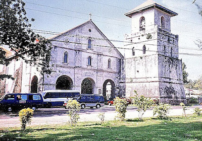
Church of La Purisima Concepcion de la Virgen Maria

We had just finished unloading our luggage and were savoring our welcome drink at our resort when our tourist van arrived to pick us up.  Barely catching our breath, we were again on the move as we had to compress a tight, pre-arranged sightseeing tour around Bohol within the day.   The province has a quite efficient road system with concrete roads encircling the province and traversing the land from Trinidad on the north and Loay in the south.  Besides this, second-class roads also connect the other towns, thereby completing a truly serviceable transportation network.  Touring the island is thus a breeze since travelers can start practically anywhere.  From Panglao, we again crossed the bridge to Tagbilaran City.  About 3 kms. out of the city, we made a photo op stopover at the Blood Compact Site at Brgy.  Bool, the site of the blood compact between Spaniard Miguel Lopez de Legaspi and Rajah Sikatuna on March 16, 1565.

The Blood Compact Site

Our first real stop was at the town of Baclayon were we visited the Church of La Purisima Concepcion de la Virgen Maria, one of the best examples of Philippine Baroque combined with Western and Eastern influences.  Reputed to be the oldest church in the country, it was first built by the Jesuit Frs.  Juan de Torres and Gabriel Sanchez in 1595.  The present coral stone church was built in 1727. The church’s simple Early Renaissance facade has a 21-m. high, massive square bell tower (now connected to the church by a portico-façade installed in 1875), a fine porch and massive stone piers (in which some of the town’s priests are entombed.   Inside are an intricately carved, gilded altar and icons plus two side retablos, all dating back to the Jesuit era.  It also has a pipe organ installed in 1824.  The pulpit, installed in 1870, is located at the epistle corner.  The floor’s glazed tiles were installed in 1875 after the completion of the portico.